Snow Cravings Continue (Dec 31-Jan 4)
Discussion: There is no point in sugar coating it. 2019 will end mild and wet and the first week or two of January also looks relatively mild. For those who dislike snow this should come as good news. For the


Discussion: There is no point in sugar coating it. 2019 will end mild and wet and the first week or two of January also looks relatively mild. For those who dislike snow this should come as good news. For the

Discussion: Above-average upper-level geopotential height anomalies will continue to dominate the pattern today (Friday) and most of Saturday. Heights should relax into a transient zonal pattern for Sunday before rebuilding to start next week. This means mild and wet today

Discussion: An area of high pressure is departing the ~Maine area as low pressure cuts through the Great Lakes behind it. This should set up a warm sector rain event for most of Friday. The line of precipitation appears pretty thin

Discussion: The upper levels appear flat/zonal through this week and into the weekend. At the surface high pressure should slowly float through the E US from Monday through most of Thursday. That should keep temps near-average under dry conditions. I

Discussion: We continue to monitor a Sudden Stratospheric Warming Event (SSWE) over the Arctic Ocean. Over the next few days we’re really going to see 10mb (stratospheric) height anomalies flex up that way. This squashes the tropospheric Polar Vortex (PV)
Discussion: A shortwave that came off the Pacific (over California) will phase with a northern stream shortwave over the southern central US and depart over the Atlantic Ocean. The surface low of interest will form “miller-A” style out of the northern

Discussion: Upper-level low energy, that influenced the departing system from this weekend, is moving out to sea as well. A trailing upper-level shortwave will dive in and keep the first part of this week cold. The coldest bottom point looks
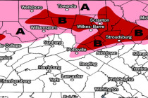
Discussion: As low pressure slides by to our S (from W to E) high pressure is sliding by to our N (also from W to E). The low is drawing up the warmer moisture while the high is pushing down the

Discussion: Our upper-level disturbance is moving out and above-average 500mb height anomalies will fill the void. That is until another, but stronger, upper-level disturbance slides through to our S this weekend. At the surface this should mean a cloudy and
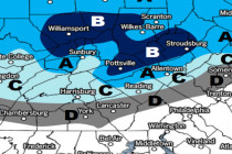
Discussion: Trends in the last 24 hours indicate a slightly northern track in the upper-level low and surface moisture beneath as well as earlier timing. The upper-level low looks to pass from W to E over the NY State/PA border and

LOCAL FORECAST | INTERACTIVE RADAR | LATEST NJ WEATHER ALERTS | WEDDING FORECAST| PRIVACY POLICY
© Copyright 2024 Weather NJ LLC. All Rights Reserved.
Some information that can be found on our website is provided by a private weather station and is not an officially recognized station for weather reporting. Though we always strive to achieve accurate reporting for our own use, it is important that you do NOT depend on the data provided here for any purpose.


