

April 1: Final Call Snow Map

Click here to view full-resolution snow map!
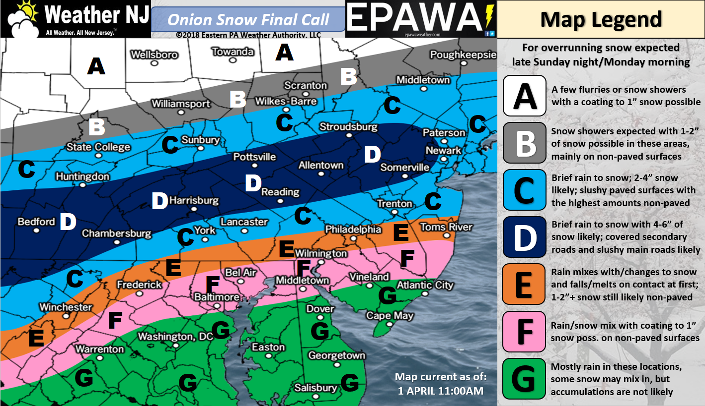
Discussion: The most recent data and live observations suggest very little change S of I-78 (compared to yesterday’s first call). The only significant change we’ve made is extending the jackpot D zone from PA into parts of NNJ. This bumps such NNJ areas from 2-4″ into 4-6″ of expected accumulation. Please keep in mind that these are maximum accumulations on cold/natural surfaces. We feel that roads and other paved surfaces will see less snow accumulation but still enough to disrupt travel along and N of I-78. Areas S of I-78 will should likely start as rain and change to all snow with little-to-no significant road accumulations. I would still treat this as a slick day to travel statewide however. If any mesobands over-perform S of I-78 (possibly even S of I-195), roads could become temporarily slushy. But to restate the the general rule here, the parallel just S of I-78 should divide the disruptive paved surface accumulation potential.
This setup involves a weak wave of low pressure traversing a Mid-Atlantic US-draped frontal boundary from W to E. The passing low to our S is weak (~1012mb) as is the high to our N (~1020mb). The convergence just happens to favor the best lifting over New Jersey for this cruel non-April fools expected spring snow event. The 500mb shortwave still looks rather weak as well. Upper-level isobars barely bend with this shortwave however there’s enough cyclonic vorticity to make the event happen. What’s mainly driving this system’s potential is a strong upper-level jet that will enhance mid-level frontogenesis (snow making) and vertical velocity (upward motion). It appears the best 850mb fronto will be located over SNJ while the best 700mb fronto sets up over NNJ. Either way, there should be enough widespread frontogenic forcing to enhance precipitation rates into the 1-2 inch per hour puke zone. This heaviest snow thump should occur between about 4-8am, maybe 5-9am. All precipitation should taper off from W to E by noon, if not by late-morning.
It still looks to me that the heaviest precipitation will fall across CNJ (between I-195 and I-78). Surface temperatures will likely keep road accumulations minimized for CNJ however. NNJ (N of I-78) should see less precipitation but cold enough temperatures for more significant stickage. SNJ should see the warmest surface temperatures and are therefore least likely to see road accumulations. I expect much of SNJ to start as rain just after midnight. Whether you want to count any non-paved surface accumulations in CNJ or even SNJ is up to you. It would likely melt quickly with the rising Monday morning sun. My largest concern for paved surface accumulations is along and N of I-78, especially NWNJ elevations.
In English: The above snow map represents how much snow we think will fall. This is a well-timed sneaky event that should start just after midnight tonight, thump between about 4-9am tomorrow morning, and taper off by noon if not earlier. As far as actual road impacts go, areas along and N of I-78 are most favored for slushy/snow covered paved surfaces (especially NWNJ elevations). Areas S of I-78 will likely see a lot of white rain hitting the streets (snow melts on street contact). Cold/natural surface accumulations are still possible in CNJ/SNJ but meh. To play it safe, assume a light slushy coating is possible on roads even as far S as I-195. Areas S of I-195 will likely start as rain and transition to snow. It’s now live-casting time. I’ll check back later tonight when precipitation is approaching from the W. Have a great rest of your Easter Sunday and please be safe! JC
For comprehensive and interactive hyper-local analysis that goes way above and beyond the detail of this public forecast, check out our premium services which include early hyper-local text notifications and guaranteed individual forum interaction. A must for outdoor businesses that depend on the best real-time data possible.
Jonathan Carr (JC) is the founder and sole operator of Weather NJ, New Jersey’s largest independent weather reporting agency. Since 2010, Jonathan has provided weather safety and forecasting services for New Jersey and immediate surrounding areas through the web, social media, and app spaces. Originally branded as Severe NJ Weather (before 2014), Weather NJ is proud to bring you accurate and responsible discussions ahead of high-stakes weather scenarios that impact the garden state. All Weather. All New Jersey.™


LOCAL FORECAST | INTERACTIVE RADAR | LATEST NJ WEATHER ALERTS | WEDDING FORECAST| PRIVACY POLICY
© Copyright 2024 Weather NJ LLC. All Rights Reserved.
Some information that can be found on our website is provided by a private weather station and is not an officially recognized station for weather reporting. Though we always strive to achieve accurate reporting for our own use, it is important that you do NOT depend on the data provided here for any purpose.
