

April 20: PM Thunderstorm Threat Elevated!
The threat for evening thunderstorms has increased. This is due to a few factors but most importantly, a break in the clouds this afternoon. Parts of SWNJ are already clearing with the rest of NJ to follow suit over the next few hours. This will allow the sun to reach the surface and destabilize the region (priming it for thunderstorms) ahead of the energy and front. There is also a wind-shear component that could make for some interesting wind gusts as well as enhance the thunderstorm probability. Given the general setup, SWNJ is favored most for severe criteria being met (wind gusts in excess of 58mph and/or hail one inch or larger). General timing impacts, as of right now, look earlier for SNJ (11PM-2AM) and even later overnight for NNJ. Let’s dive into some details…
NWS SPC Convective Outlook
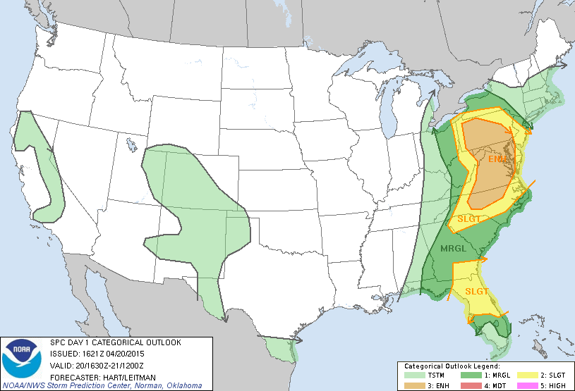
The latest convective outlook per the National Weather Service Storm Prediction Center (NWS SPC), has placed extreme SWNJ in the “enhanced” risk level. Most of SNJ and CNJ are now in the “slight” risk level with NNJ in the “marginal” risk level. This setup traditionally warrants severe thunderstorm watches so look for the NWS to trigger such by late afternoon. Severe Thunderstorm Warnings (not watches) will only be triggered when severe criteria is reported by trained spotters and/or radar observation.
Surface-Based CAPE (Convective Available Potential Energy)
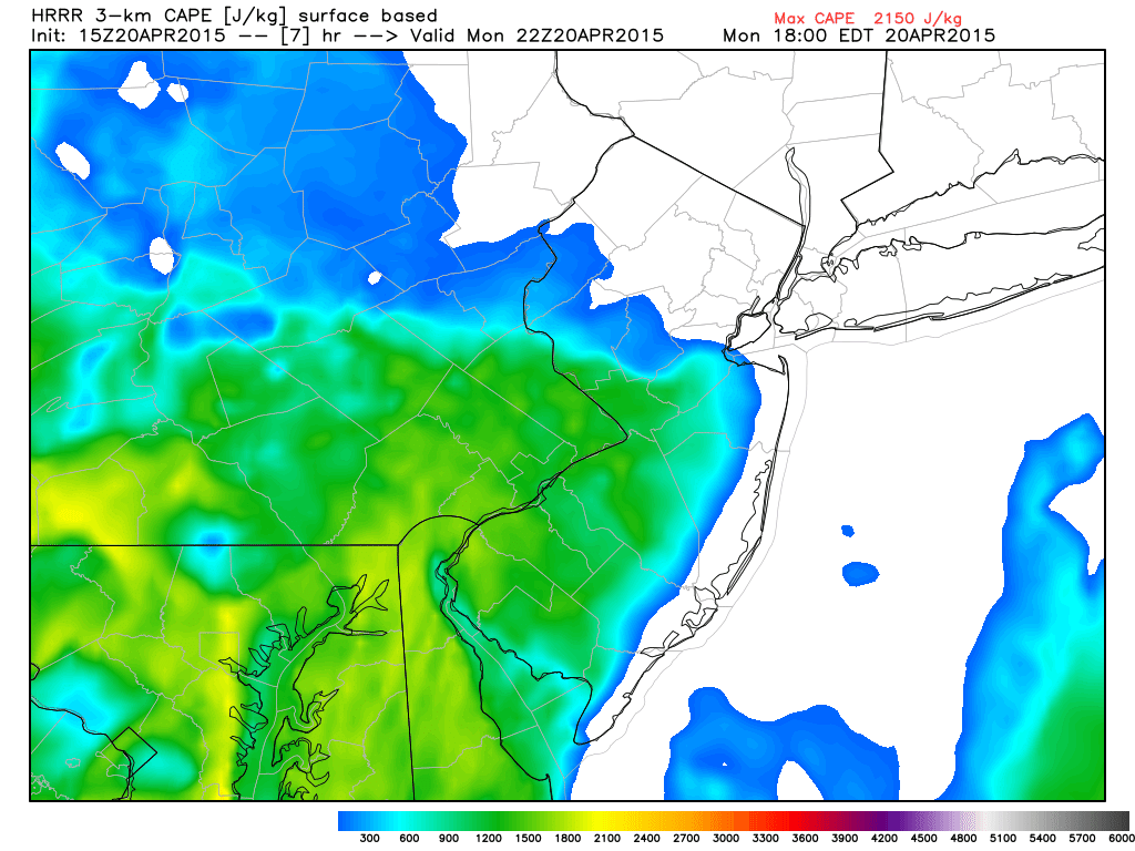
CAPE is just one of many severe weather parameters but it’s generally an adequate tool to measure atmospheric instability. It’s measured in joules per kilogram (j/kg) and the higher it is, the more instability exists. The strongest influencer of CAPE is diurnal solar surface heating, which we should have this afternoon between cloud breaks. The above image represents surface-based CAPE (SBCAPE) which appears to be strong at 1500-2000 j/kg. After a look at thermodynamic NAM soundings, mixed-layer CAPE (MLCAPE) appears to be marginal at about 700-900 j/kg. With that being said, there exists enough instability at all levels to warrant the risk for severe thunderstorms, especially for western areas of CNJ and SNJ. The coast will feature low instability since it’s last to clear and is very much controlled by the ocean surface temperatures. With that said, remnant thunderstorms could still make it to the coast just not as strong as interior areas.
Bulk Wind Shear (SFC-500mb)
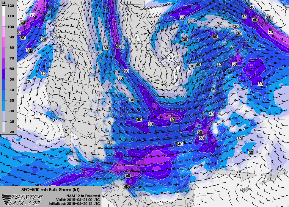
SFC-500mb bulk wind shear represents the change in wind direction from the surface to about 18,000 feet of altitude. The higher the shear, the better the chance for damaging winds and/or tornadoes. In the case of tonight, we’re looking at ~40 knot wind shear which is not astronomically high but marginal enough to also warrant the severe thunderstorm risk. Marginal CAPE and marginal wind shear are enough in-combination to produce severe thunderstorms.
In English: Thunderstorms are possible this evening, featuring damaging wind gusts, heavy downpours, frequent lightning, and possibly hail. A small tornado threat exists to our west but not currently for New Jersey (worth noting). Western parts of central and southern New Jersey have a better chance than other parts of the state IMO to meet severe thunderstorm criteria. Timing looks like 11PM-2AM for SNJ and midnight-3AM for NNJ. Coastal areas will see air that is more stable due to cold maritime flow off the ocean, so less of a chance there. It should all clear well out to sea by sunrise tomorrow morning.
Check out our friends at Mid-Atlantic Waterproofing—serving all of New Jersey and the general Mid-Atlantic US with waterproofing, foundation repair and basement dry-out services. With a rainy spring anticipated, it’s probably not a bad idea to schedule a FREE foundation inspection. Be safe! JC
Jonathan Carr (JC) is the founder and sole operator of Weather NJ, New Jersey’s largest independent weather reporting agency. Since 2010, Jonathan has provided weather safety and forecasting services for New Jersey and immediate surrounding areas through the web, social media, and app spaces. Originally branded as Severe NJ Weather (before 2014), Weather NJ is proud to bring you accurate and responsible discussions ahead of high-stakes weather scenarios that impact the garden state. All Weather. All New Jersey.™


LOCAL FORECAST | INTERACTIVE RADAR | LATEST NJ WEATHER ALERTS | WEDDING FORECAST| PRIVACY POLICY
© Copyright 2024 Weather NJ LLC. All Rights Reserved.
Some information that can be found on our website is provided by a private weather station and is not an officially recognized station for weather reporting. Though we always strive to achieve accurate reporting for our own use, it is important that you do NOT depend on the data provided here for any purpose.
