

April 6: Rain Approaching

Low pressure currently over the Great Lakes is on its way to our region. It will quickly jump to the NJ area tomorrow and then lift to the N out of our region by Friday afternoon. This should bring some over-running precipitation to the region as well as more concentrated rainfall along the cold frontal passage.
At 500mb, the wave appears to weaken before reaching our region. Also the trough axis is fairly positive. The Saturday shortwave is much more interesting to me given its more favorable trough axis and better-defined energy. I’ll be dedicating an article to that system tomorrow morning. This allows me to review better-sampled data overnight.
For now, here is the total expected amount of rainfall between Thursday morning and Friday afternoon. This is the latest GFS which is supported by short-range guidance as well:
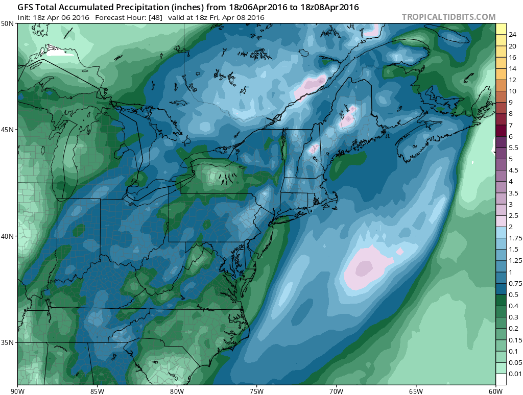
Again, keep in mind that there should be a more concentrated band of precipitation along the cold front later Thursday (afternoon-evening). Embedded thunderstorms are possible along this frontal passage. I would at least expect some gusty winds to kick up.

In English: Rain is possible starting tomorrow morning and ending between Friday morning and afternoon. Heaviest rainfall should occur Thursday afternoon-evening with thunderstorms possible during. Other than that this seems like a run-of-the-mill moderate (if not just nuisance) rain and wind event. NWNJ is favored to see the most amount of rainfall (up to 1.5″) and SENJ is favored to see the least (.10″ to .25″). Have a great night and be safe! JC
Jonathan Carr (JC) is the founder and sole operator of Weather NJ, New Jersey’s largest independent weather reporting agency. Since 2010, Jonathan has provided weather safety and forecasting services for New Jersey and immediate surrounding areas through the web, social media, and app spaces. Originally branded as Severe NJ Weather (before 2014), Weather NJ is proud to bring you accurate and responsible discussions ahead of high-stakes weather scenarios that impact the garden state. All Weather. All New Jersey.™


LOCAL FORECAST | INTERACTIVE RADAR | LATEST NJ WEATHER ALERTS | WEDDING FORECAST| PRIVACY POLICY
© Copyright 2024 Weather NJ LLC. All Rights Reserved.
Some information that can be found on our website is provided by a private weather station and is not an officially recognized station for weather reporting. Though we always strive to achieve accurate reporting for our own use, it is important that you do NOT depend on the data provided here for any purpose.
