

Arthur’s Latest Track
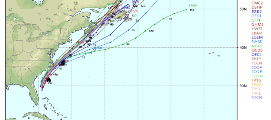
Again, let me re-emphasize that our biggest threat over the next 72 hours is associated with a series of cold frontal passages approaching from our west, NOT from a tropical cyclone passing by to our southeast. Although Arthur will easily reach Category 1 hurricane strength and disrupt the OBX region Friday morning, he will not be threatening New Jersey.
The first cold front will come through this evening bringing heavy rain and possibly severe thunderstorms just ahead of it. Another cold front will move through tomorrow evening-overnight into Friday morning. This will also likely bring heavy rain and thunderstorms. Until that second cold front clears the coast, remnant showers could interact with the NW outer bands of Arthur and keep it wet Friday morning.
Eventually the front will push through and clear everything out by Friday afternoon. Friday afternoon and evening should be drying out with northerly winds (10-20mph likely) and then Saturday-Sunday look pleasant and downright amazing. So heavy rain and storms tonight through Friday morning followed by a gorgeous holiday weekend. Be safe! JC
Jonathan Carr (JC) is the founder and sole operator of Weather NJ, New Jersey’s largest independent weather reporting agency. Since 2010, Jonathan has provided weather safety and forecasting services for New Jersey and immediate surrounding areas through the web, social media, and app spaces. Originally branded as Severe NJ Weather (before 2014), Weather NJ is proud to bring you accurate and responsible discussions ahead of high-stakes weather scenarios that impact the garden state. All Weather. All New Jersey.™


LOCAL FORECAST | INTERACTIVE RADAR | LATEST NJ WEATHER ALERTS | WEDDING FORECAST| PRIVACY POLICY
© Copyright 2024 Weather NJ LLC. All Rights Reserved.
Some information that can be found on our website is provided by a private weather station and is not an officially recognized station for weather reporting. Though we always strive to achieve accurate reporting for our own use, it is important that you do NOT depend on the data provided here for any purpose.
