

Aug 14: Tropics Update
Gert will stay out to sea as another wave departs the Cape Verde region…
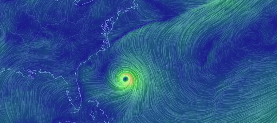
On the above image you can see Gert as well as the frontal boundary that will prevent Gert from reaching the east coast. Gert is currently intensifying in a warm water low shear environment. I wouldn’t be surprised to see category 2 strength reached in the next 24 hours. It is currently however just below category 1 criteria as a strong tropical storm. Eventually the frontal boundary, attached to an upper-level trough, will carry Gert far away to the NE. I think the most noticeable kick eastward will be on Wednesday morning when the upper-level trough really grabs hold of the system. Until then Gert should drift slowly northward between the Outer Banks of North Carolina and Bermuda before turning to the NE.
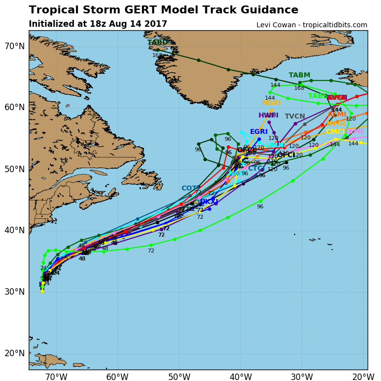
East coast impacts for the US do not include landfall. Gert could produce rougher surf along the coast however. Expect potentially dangerous rip currents and generally increased swell size from now through about Thursday night/Friday morning. Gert might be cranking pretty hard out there tomorrow. A surfers paradise or inexperienced swimmer’s nightmare. Please listen to lifeguards or any other local government authority guidance regarding swimming conditions, flags, etc. A few people have already died this year. Here’s the spaghetti plots for Gert’s future path:
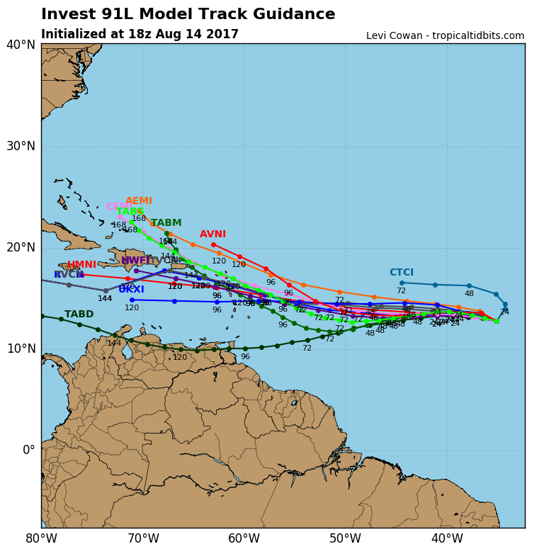
Once Gert is on the way to the N Atlantic, our next tropical system of interest (Invest 91L) should be crossing the Atlantic Ocean towards the Eastern Caribbean. It is far too early to speculate this system’s future path beyond the Eastern Caribbean area. All we can do now is watch it approach the Lesser Antilles and monitor Saharan Desert dust, wind shear and upper-level patterns ahead of it for hints on steering guidance. If, and this is a BIG IF, this system were to develop into a hurricane and threaten the east coast, it would not be until the August 25-28 period. It would be named Harvey. I wouldn’t worry too much about it at this point. Just like with winter storms, a lot can change between now and then. The increased activity in the tropics should come to no surprise however as we closer approach peak hurricane season for the Atlantic Hurricane Basin. Here are the spaghetti plots for Invest 91L’s future path:
In English: Gert is a miss for the US East Coast but could still produce nuisance/hazardous surf conditions along the coast over the next few days. There’s another tropical wave off W Africa heading towards the Caribbean which I’m only casually monitoring for now. I’ll discuss every few days until we’re within a more confident forecasting range (within 7 days of possible east coast impact if any). To sum it all up, there are no direct tropical threats to New Jersey for at least the next 10 days or so. Be safe! JC
Jonathan Carr (JC) is the founder and sole operator of Weather NJ, New Jersey’s largest independent weather reporting agency. Since 2010, Jonathan has provided weather safety and forecasting services for New Jersey and immediate surrounding areas through the web, social media, and app spaces. Originally branded as Severe NJ Weather (before 2014), Weather NJ is proud to bring you accurate and responsible discussions ahead of high-stakes weather scenarios that impact the garden state. All Weather. All New Jersey.™


LOCAL FORECAST | INTERACTIVE RADAR | LATEST NJ WEATHER ALERTS | WEDDING FORECAST| PRIVACY POLICY
© Copyright 2024 Weather NJ LLC. All Rights Reserved.
Some information that can be found on our website is provided by a private weather station and is not an officially recognized station for weather reporting. Though we always strive to achieve accurate reporting for our own use, it is important that you do NOT depend on the data provided here for any purpose.
