

Aug 21: Hurricane Danny Update
Hurricane Danny has intensified. He has been able to stay just south of inhibitive factors such as dry Saharan air/dust, and wind shear. He could possibly intensify further but eventually, he’s going to have to cross a strong wind shear environment before approaching the NE Caribbean region. The latest guidance takes him right over the Leeward Islands of the Lesser Antilles and towards the high elevations of Hispaniola. The shear which Danny will encounter in the short-term as well as geographic elevation disruption in the mid-to-long range almost certainly guarantees substantial weakening of the tropical system. I imagine Danny has a small shot at category 3 (Major) status before this weakening begins but he should most likely remain a category 2 Hurricane for now and weaken down to a weak category 1/strong Tropical Storm for NE Caribbean impact in the Sunday-Monday time-frame.
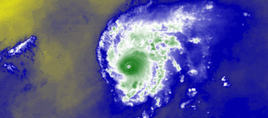
While models have done a great job on projected path, they have underestimated the strength of Hurricane Danny in my opinion. He’s down to 976mb with sustained maximum winds of 105mph. As you can see on the infrared satellite image from NOAA, cloud tops are high and cold around a defined eye, which is a sure sign of a healthy tropical system. The other thing that jumps out at me is Danny’s size. He is small and compact which has maintained a healthy intensification zone that’s closed off to the surrounding fairly-inhibitive environment. I’m interested to see Danny’s ability to retain strength in the strong wind shear environment that will soon present itself.
For now, we keep watching with high uncertainty beyond the NE Caribbean region. If the current model guidance holds then Danny will shred apart into tropical remnants over the northern Caribbean by Tuesday-Wednesday. A slight northward trend however, would mean less high-elevation terrain interference and a course for the Bermuda Triangle where water is warm and shear is low. This would put the entire east coast on alert real quick but that is not currently indicated. Just saying… These are the two possibilities I see right now.
There are some other areas under investigation by the NHC. One is right off our coast which should, at most, rough up our surf. The other is coming off western Africa. You can follow along on our new interactive product, the Eye Wall featuring automatic and frequent updates for all things “Tropical Atlantic” as well as disaster recovery efforts should a direct tropical NJ hit occur as it has in the past. Be safe! JC
Be safe! JC
Jonathan Carr (JC) is the founder and sole operator of Weather NJ, New Jersey’s largest independent weather reporting agency. Since 2010, Jonathan has provided weather safety and forecasting services for New Jersey and immediate surrounding areas through the web, social media, and app spaces. Originally branded as Severe NJ Weather (before 2014), Weather NJ is proud to bring you accurate and responsible discussions ahead of high-stakes weather scenarios that impact the garden state. All Weather. All New Jersey.™


LOCAL FORECAST | INTERACTIVE RADAR | LATEST NJ WEATHER ALERTS | WEDDING FORECAST| PRIVACY POLICY
© Copyright 2024 Weather NJ LLC. All Rights Reserved.
Some information that can be found on our website is provided by a private weather station and is not an officially recognized station for weather reporting. Though we always strive to achieve accurate reporting for our own use, it is important that you do NOT depend on the data provided here for any purpose.
