

Aug 26: East Coast Storm to Form
A hybrid-type storm will form and move up the coast this week. Let’s break it down…
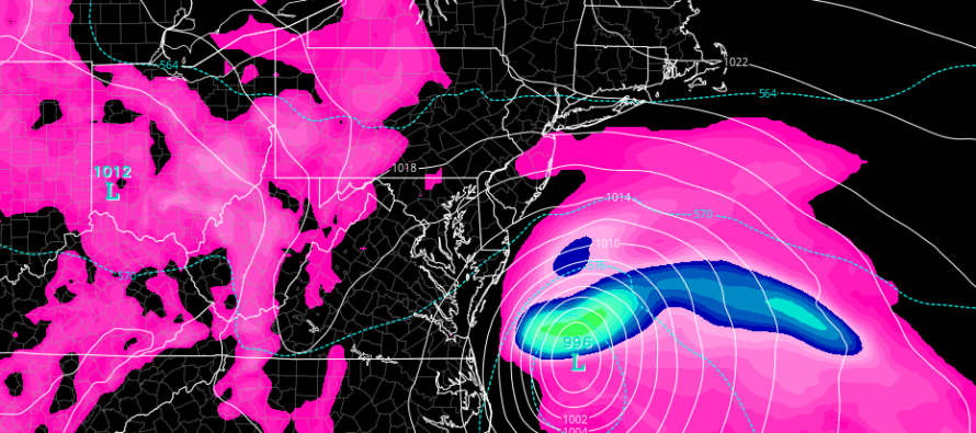
Discussion: At the upper levels, a trough will be swinging through the Great Lakes region this week as a surface feature organizes near/over Florida and slides up the east coast towards OBX. The upper-level trough will actually interact with the upper-level remnants of Harvey before interacting with the energy moving up the coast. This could tug the low pressure system towards New Jersey some after ejecting off OBX.
Should this system become a named tropical storm, she would be called Irma. I think this is possible as long as most initial organization occurs closer to Florida and Georgia and away from the coast. Those water temperatures down there still support tropical development. However once the system gets further up the coast, water temperatures decrease and will likely deteriorate the systems ability to maintain a warm tropical core. It would then likely be categorized as a sub-tropical cyclone which would mean a larger wind field overall without the tightly-wrapped tropical core higher wind speeds near the eye. There’s also a lot of land interaction expected with the SE US coast as it tracks from Florida to OBX. Most model guidance keep the system above 990mb even at its closest point to New Jersey early Wednesday morning.
With all of that said, I’m not leaning towards a high-impact system for New Jersey. Nuisance conditions are certainly possible, ranging from just a stiff breeze off the ocean with mist/drizzle to a rainier and windier solution. I think a few above-average high tides are possible given the prolonged period of onshore flow. Minor tidal flooding and beach erosion would therefore be on the table but nothing “non run-of-mill” for the Jersey Shore.
Once this system clears out by Wednesday night/Thursday morning, conditions should improve for Labor Day Weekend. With Harvey’s remnants expected to stay in place and basically rain itself out, there are no expected downstream impacts for New Jersey from him. We just have to deal with this coastal system either fully ejecting off OBX with minimal impact or possibly passing by close enough for some rain, wind and possibly minor flooding in the Tuesday-Wednesday period.

In English: Onshore flow (wind coming off the ocean) should ramp up between now and Tuesday. A coastal storm system, possibly named Irma, should track from Florida to the Outer Banks of North Carolina between now and Tuesday. This system could either fully turn east out to sea after passing the Outer Banks or get yanked towards New Jersey some (not completely) and bring rain and wind in the Tuesday-Wednesday period. Either way I am not expecting high-impact conditions…only nuisance conditions that range from just a windy/raw day to a run-of-mill coastal storm. We should then improve heading into Labor Day Weekend as high pressure moves into the region. Have a great day and please be safe! JC
Top model image credit: Tropical Tidbits.
Jonathan Carr (JC) is the founder and sole operator of Weather NJ, New Jersey’s largest independent weather reporting agency. Since 2010, Jonathan has provided weather safety and forecasting services for New Jersey and immediate surrounding areas through the web, social media, and app spaces. Originally branded as Severe NJ Weather (before 2014), Weather NJ is proud to bring you accurate and responsible discussions ahead of high-stakes weather scenarios that impact the garden state. All Weather. All New Jersey.™


LOCAL FORECAST | INTERACTIVE RADAR | LATEST NJ WEATHER ALERTS | WEDDING FORECAST| PRIVACY POLICY
© Copyright 2024 Weather NJ LLC. All Rights Reserved.
Some information that can be found on our website is provided by a private weather station and is not an officially recognized station for weather reporting. Though we always strive to achieve accurate reporting for our own use, it is important that you do NOT depend on the data provided here for any purpose.
