

Aug 5: Storms Expected Tomorrow
Isolated showers and thunderstorms are possible throughout the remainder of this evening. Tomorrow holds a greater chance for storms due to a cold front moving through. Expected time of impact is between late afternoon and early evening. Storms riding the front should approach NWNJ as early as 2PM and clear SENJ as late as 10PM. I’ll be able to narrow that down tomorrow morning. As always, NWNJ has a greater chance than SENJ (fizzling effect). Here’s some supporting guidance from the high-res NAM (simulated precipitation intensity during late afternoon):
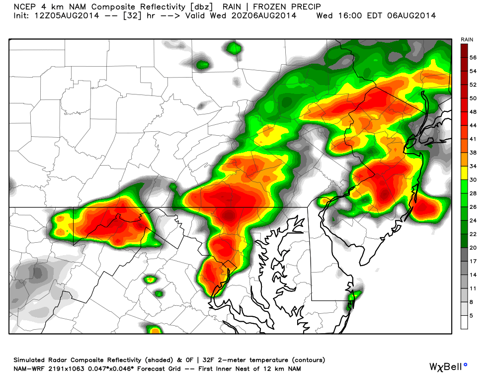
As far as storm intensity there are a few things to consider. Instability will be strong at the surface but weaker aloft. Bulk wind shear (surface-500mb) will be about 30-40kts. We have what’s known as a trigger (the cold front) which will basically set the storms off as it moves through. With that being said, only isolated cases of severe thunderstorms are possible. Storms of just “strong” criteria are much more likely.
In English: Expect rain and thunderstorms to move through sometime tomorrow afternoon-evening. Nothing crazy. Just gusty rain and lightning. The weather that will follow tomorrow night into Thursday will feel like a late-September time dilation.
Asbury Park Carousel House image by Chris Spiegel of Blur Revision Media Design. Model image reproduced with permission by WeatherBell Analytics. Be safe! JC
Jonathan Carr (JC) is the founder and sole operator of Weather NJ, New Jersey’s largest independent weather reporting agency. Since 2010, Jonathan has provided weather safety and forecasting services for New Jersey and immediate surrounding areas through the web, social media, and app spaces. Originally branded as Severe NJ Weather (before 2014), Weather NJ is proud to bring you accurate and responsible discussions ahead of high-stakes weather scenarios that impact the garden state. All Weather. All New Jersey.™


LOCAL FORECAST | INTERACTIVE RADAR | LATEST NJ WEATHER ALERTS | WEDDING FORECAST| PRIVACY POLICY
© Copyright 2024 Weather NJ LLC. All Rights Reserved.
Some information that can be found on our website is provided by a private weather station and is not an officially recognized station for weather reporting. Though we always strive to achieve accurate reporting for our own use, it is important that you do NOT depend on the data provided here for any purpose.
