Back to homepage

Feature POST on Homepage

Dec 30: Saturday Live Observations

Dec 30: Saturday Live Observations

🕔10:07, 30.Dec 2017

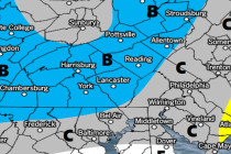
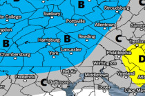
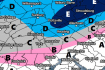
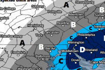
Discussion: The most impressive remnant of the northern stream energy has moved through S PA and into SNJ this morning. This initial energy is now moving out into the ocean however the weak coastal cyclogenesis has begun near Delmarva. This weak

Read Full Article
Dec 29: Final Call Snow Map for Saturday (Tomorrow)

Dec 29: Final Call Snow Map for Saturday (Tomorrow)

🕔17:21, 29.Dec 2017

Click here for full-resolution snow map! Discussion: No real changes to last night’s forecast. Snowfall is currently approaching the Ohio Valley region. This should spread through PA and N MD overnight before exiting across NJ tomorrow. Timing is between dusk and

Read Full Article
Dec 28: First Call Snow Map for Saturday

Dec 28: First Call Snow Map for Saturday

🕔17:01, 28.Dec 2017

Click here to view full resolution snow map! Discussion: An area of northern stream energy will pass through New Jersey on Saturday from W to E. This energy split off of an incoming wave from the Pacific Ocean near Washington

Read Full Article
Dec 27: Weekend Snow Discussion

Dec 27: Weekend Snow Discussion Updated

🕔20:00, 27.Dec 2017

Discussion: The December 29-30 period has presented a general storm signal for some time now. And that’s all we’ve been advertising due to the complex setup of multiple northern stream shortwaves coming in from and around the Arctic trough…as well

Read Full Article
Cold Week Expected (Dec 25-29)

Cold Week Expected (Dec 25-29)

🕔17:18, 24.Dec 2017

Discussion: Please be careful tonight, especially in NWNJ, as wintry precipitation is likely. We have not changed our forecast and snow map. Immediately following this system will be strong winds out of the W/NW. Gusts of 40mph+ are possible throughout

Read Full Article
Dec 23: Weather to Impact Holiday Travel

Dec 23: Weather to Impact Holiday Travel

🕔14:05, 23.Dec 2017

Click here for full resolution snow map! Discussion: Once today’s warmer disturbance tracks away to our NE, two more disturbances should track parallel to the Appalachian Mountains between Sunday-Monday (Christmas Eve-Day). The low closer to the Apps will likely transfer to

Read Full Article
Unsettled Conditions Expected (Dec 22-24)

Unsettled Conditions Expected (Dec 22-24)

🕔19:01, 21.Dec 2017

Discussion: An area of ridging should dominate the weather pattern through Sunday. This means milder temperatures overall with an especially gloomy Saturday. While Saturday does not look like an all-day washout, it should feature periods of fog, drizzle and on/off

Read Full Article
Milder Conditions Expected (Dec 18-22)

Milder Conditions Expected (Dec 18-22)

🕔20:48, 17.Dec 2017

Discussion: Real quick, scattered light precipitation could fall overnight tonight. Only NJ areas N of  I-78 would be cold enough for wintry precipitation. Very light amounts are expected but could still slick-up the early AM rush hour commute tomorrow. Moving

Read Full Article
Dec 15: Snow Map for Today

Dec 15: Snow Map for Today

🕔09:56, 15.Dec 2017

Click here to see full resolution snow map! Discussion: A strong 250mb jet streak is howling from W to E over the OBX area. 500mb height anomalies are below average over the E US as several weak shortwaves couple up

Read Full Article
Cold Possibly Snowy Start. Milder Finish (Dec 15-17)

Cold Possibly Snowy Start. Milder Finish (Dec 15-17)

🕔16:36, 14.Dec 2017

Discussion: About the only thing worth discussing this weekend is a coastal disturbance. The low should form off OBX Friday AM and track SE of the 40N/70W benchmark out-to-sea through Friday night/early Saturday AM. The flow is progressive (a quick

Read Full Article