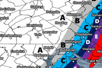
Wintry Start to the Week (Jan 8-12)
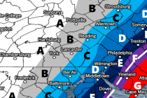
Please click here for full resolution snow map! Discussion: The upper-levels indicate a back-and-forth pattern emerging as 500mb height anomalies bounce from positive to negative extremes. This is typical of the current La Nina state. Therefore we should moderate this