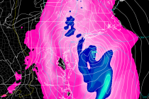
Colder Transition Expected (Nov 6-10)
Discussion: The upper levels should gradually transition from positive 500mb height anomalies to negative between now and Wednesday. NNJ elevations (mostly NWNJ) has the chance to see their first frozen precipitation of the year Tuesday evening through early Wednesday morning.