Cooler Rainy Week Expected (June 1-5)

At least the first half of the week looks wet with much cooler temperatures than we’ve recently acclimated to. With a little luck we’ll be clear and sunny heading into the weekend depending on how much tropical moisture kicks up the coast. A tropical storm is modeled to form off the SE US this weekend. Before it forms it could add to the current above-average rainfall period. Let’s break it down:
Monday should only top out in the 60s for the elevations of NWNJ while the rest of New Jersey flirts with 80 (different worlds to the north and south of the frontal boundary). Sun is likely at times but clouds, rain and thunderstorms should dominate the day with an overall tropical moisture feel. Winds should be mixed but very light. Overnight lows should fall into the 50s (NWNJ) and 60s (rest of New Jersey).
Tuesday will be cooler for the entire state with the frontal boundary finally pushed through to our S. Expect highs in the 60s statewide with more overcast skies and rainfall ending by afternoon-early evening. Winds should be light out of the N/NE. Overnight lows should fall into the upper-40s (NWNJ) and 50s (rest of New Jersey).
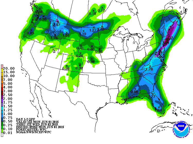
Expected rainfall from Monday morning through Tuesday night via NOAA NWS (another 1-3 inches):
Wednesday highs should reach into the 70s away from the ocean and possibly just the 60s along the immediate coast. Skies should feature a mixed bag of sun and clouds with a light-to-breezy easterly onshore flow. Coastal regions will see higher winds than inland. Overnight lows should fall into the upper-40s (NWNJ) and 50s (rest of New Jersey).
Thursday highs should reach the lower-70s with mostly cloudy skies during the day. Easterly winds should continue, lighter inland and breezier along the coast. Only a small chance of isolated rain showers exist. Otherwise overnight lows should fall into the 50s (NWNJ) and 60s (rest of New Jersey).
Friday highs should break 80 for most of the state. The coast might stay in the 70s. Skies should be giving way to sun but more humid which always carries a chance for afternoon-evening thunderstorms. Winds should be light out of the S/SE which is why it will stay cooler along the coast. Overnight lows should fall into the lower-60s statewide.
An early look at the weekend indicates 70s and 80s with more mixed humid conditions. We’ll have to watch the SE US tropical storm formation and what effects it might have on New Jersey. As of now it just looks like enhanced surf but it might feed moisture into a frontal boundary that could bring more rain. I’ll be tracking. Also, I’ll have a long-range look at the month of June posted this evening.
This Monday-Friday Outlook is proudly sponsored by weathertrends360 (www.weathertrends360.com). Through 150 years of world wide weather data analysis, weathertrends360 has developed proprietary algorithms and methods that predict weather up to a year with 84% accuracy. They are second to none in the long range so check them out for business planning, travel planning, etc.
Be safe and have a great week! JC
Jonathan Carr (JC) is the founder and sole operator of Weather NJ, New Jersey’s largest independent weather reporting agency. Since 2010, Jonathan has provided weather safety and forecasting services for New Jersey and immediate surrounding areas through the web, social media, and app spaces. Originally branded as Severe NJ Weather (before 2014), Weather NJ is proud to bring you accurate and responsible discussions ahead of high-stakes weather scenarios that impact the garden state. All Weather. All New Jersey.™


