

Dec 10: Coastal/Snow Storm Update
What a bizarre storm system! So far there have been a few curveballs thrown but here’s a quick recap and what to expect this evening through tomorrow.
First, the rain ended yesterday morning/early afternoon which was earlier than scheduled. A decent amount fell in most across the region but some areas saw lesser amounts. This was due to a dry slot in precipitation coupled with convective banding (robbing SWNJ with sinking air and delivering to coastal/SENJ via enhanced lifting). Here are the official precipitation numbers so far from the National Weather Service.
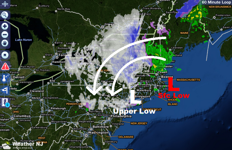
Then, the upper level 500mb low was a little late to cutoff and pull the surface low westward last night. That instead happened this morning. Normally this would result in a back end snow miss but surrounding high pressure is currently holding the upper level low over New York City. This has done a few things. It has brought much colder air to the upper levels of the atmosphere and has created surface instability by chilling the 700mb and 850mb levels to the point of being 10-15 degrees colder than the surface. Hence, there is lifting occurring that is feeding convective snowfall across the region.
As of this moment, the snowfall is having trouble sticking due to warmer surface temperatures. As the sun sets, temperatures will fall into the 20s for most of the state. This should result in overnight accumulations. When all is said and done, I still think NWNJ should pick up at least a few inches with trace amounts (maybe an inch) for lower elevations. Extreme SENJ and coast would have the least expectations for accumulations. The following image (from our interactive radar) shows the precipitation that will feed the region from the north overnight along with current positions of the upper level low and surface low. This setup will stay this way for another 18-24 hours before finally moving out to the NE:
In English: Light to moderate snow showers/squalls will occur this evening and overnight before tapering off tomorrow. NWNJ and some lower parts of NENJ should end up with at least a few inches of accumulations ending tomorrow with lesser amounts as you head SE towards the coast. Be safe! JC
Jonathan Carr (JC) is the founder and sole operator of Weather NJ, New Jersey’s largest independent weather reporting agency. Since 2010, Jonathan has provided weather safety and forecasting services for New Jersey and immediate surrounding areas through the web, social media, and app spaces. Originally branded as Severe NJ Weather (before 2014), Weather NJ is proud to bring you accurate and responsible discussions ahead of high-stakes weather scenarios that impact the garden state. All Weather. All New Jersey.™


LOCAL FORECAST | INTERACTIVE RADAR | LATEST NJ WEATHER ALERTS | WEDDING FORECAST| PRIVACY POLICY
© Copyright 2024 Weather NJ LLC. All Rights Reserved.
Some information that can be found on our website is provided by a private weather station and is not an officially recognized station for weather reporting. Though we always strive to achieve accurate reporting for our own use, it is important that you do NOT depend on the data provided here for any purpose.
