

Dec 10: Long Range Discussion
After very warm temperatures this weekend, I think we’re at least looking at a transient colder period starting around December 15. Modeled teleconnections are indicating a period of -AO and -NAO between December 14-18. This would traditionally result in colder conditions for the east coast from blocking and Arctic spillage. What doesn’t look good is the slightly negative modeled PNA for the same period. This would mean more of a trough pattern for W. US and ridge pattern for the E. US. We want to see the opposite for a snow storm, a positive PNA. Therefore, the jet stream dynamics coming off the Pacific Ocean are mostly unfavorable for a big east coast snow storm as counteracting teleconnections flatten the pattern across the US. That doesn’t mean that a coastal surface low off the sub-tropical jet stream can’t perfectly position itself for some interior/higher elevation snow. A lot would have to happen in a small window of time but IMO that would be a thread the needle situation.
Model guidance has been showing storm signals in the December 15-16, 18-20 and 22-23 periods but again, this is long range and only for discussion.
The December 15-16 signal looks like a strong GLC (Great Lakes Cutter) that will cut into Canada well to our west and bring rain to New Jersey (next ~Tuesday). This should be the cold front that ends the crazy warm expected weekend weather.
The December 18-20 signal has a poor temperature profile for most of New Jersey. With that said, snow would only be possible for higher elevations of NWNJ. The coastal low’s track would ultimately determine if that snow line wanted to come SE to the I-95 corridor or not. Again…meh for now but watching.
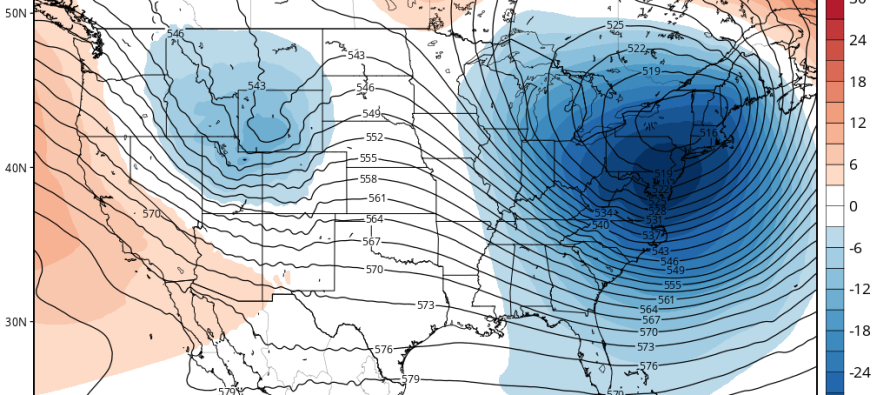
The December 22-23 signal is still in fantasy range so not putting too much stock into it. For uknowwhats and giggles, the low rapidly bombs off New Jersey bringing warmer rain to start and snow to end. With such a volatile and unfavorable pattern, I need to see some correlating support on multiple models within the 7-day forecasting range to even begin to get excited about this. 500mb heights however do look the coldest for this period (above image) so will monitor.
In English: Several storm signals are showing between now and the holidays but the general pattern appears unfavorable for any large snow storms. At this point, I think we maintain the course for longer periods of above-average temperatures and shorter transient periods of colder temperatures capable of producing snow under “thread the needle” pattern conditions. El Nino is kicking and nothing has changed. This was all expected. As soon as a sustainable colder pattern is on the horizon, I’ll let you know. For now, we bake and hope. Be safe! JC
Jonathan Carr (JC) is the founder and sole operator of Weather NJ, New Jersey’s largest independent weather reporting agency. Since 2010, Jonathan has provided weather safety and forecasting services for New Jersey and immediate surrounding areas through the web, social media, and app spaces. Originally branded as Severe NJ Weather (before 2014), Weather NJ is proud to bring you accurate and responsible discussions ahead of high-stakes weather scenarios that impact the garden state. All Weather. All New Jersey.™


LOCAL FORECAST | INTERACTIVE RADAR | LATEST NJ WEATHER ALERTS | WEDDING FORECAST| PRIVACY POLICY
© Copyright 2024 Weather NJ LLC. All Rights Reserved.
Some information that can be found on our website is provided by a private weather station and is not an officially recognized station for weather reporting. Though we always strive to achieve accurate reporting for our own use, it is important that you do NOT depend on the data provided here for any purpose.
