

Dec 11: Possible White Christmas Detected!

For the winter lover who lives along and SE of the I-95 corridor, December has been pretty “meh” so far. Some strong long-range signals indicate that’s about to change for the holidays and heading into January. While it’s way too soon to specify IMBY (In My Back Yard) details, there are certainly over-arching hints at an environment favorable for east coast snow storms. Let’s dive in, shall we?
In November a Pacific Ocean typhoon named Nuri broke barometric pressure records as it moved into the Bering Sea. It then plunged northward into polar/Arctic regions resulting in a major jet stream dip (trough) for the eastern US. What happens upstream reflects opposite downstream. This brought record cold to the mid-Atlantic and northeast US which had a familiar feel coming off of last winter’s polar vortex anomaly. Then all of a sudden the true Arctic air retreated to the other side of the Northern Hemisphere and we’re now dealing with marginal temperature setups for the low pressure disturbances that are forming. When you drill this logic down in layman’s terms, the snow/rain line for significant accumulations has been falling to the NE of the I-95 corridor rather than snow to the coast.
We’ll likely stay in this setup for the next 10 days or so with a few more disturbances moving through the region. I’m currently looking at the December 16-17 and December 19-23 periods for such. These again will struggle to bring snow to the coast but should at least drop some accumulations possibly along and NW of the I-95 corridor. This would mean a White Christmas for anyone who still has snow on the ground come December 24-25 but wait…
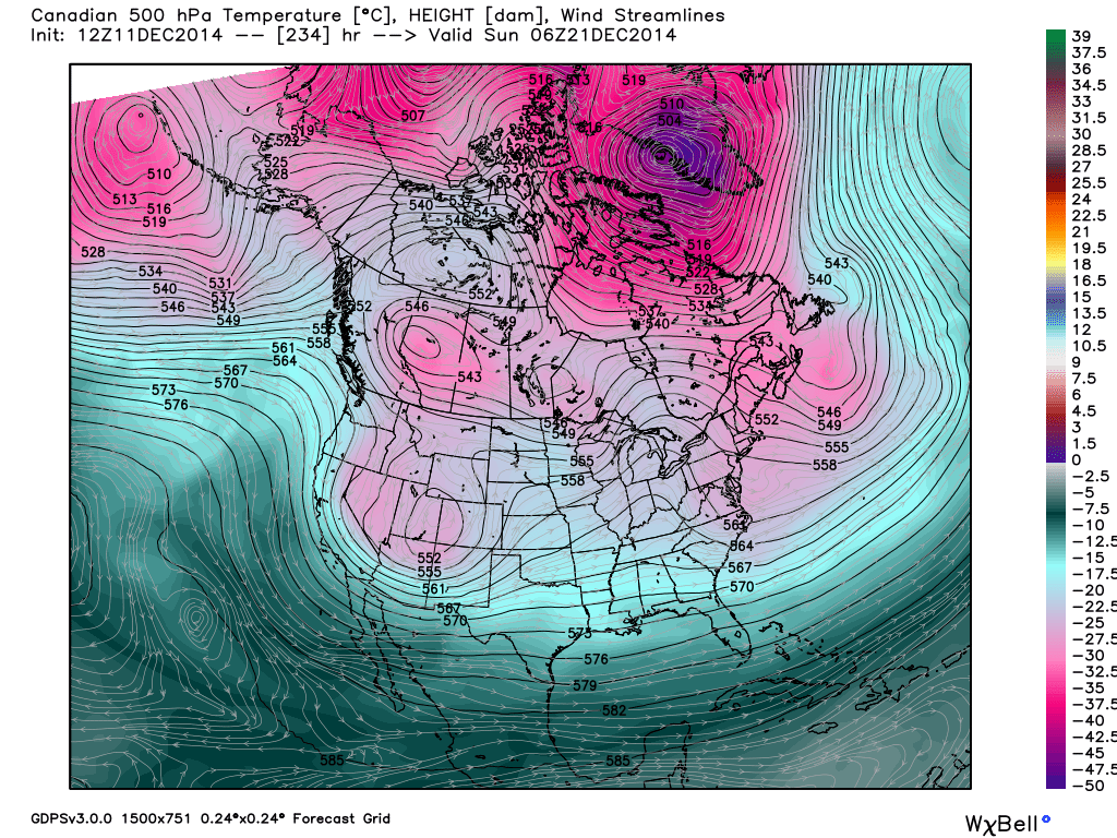
Another disturbance is modeled in the very long range right around the December 23-24th period but that disturbance could be flirting with the return of true Arctic air. A ridge is modeled to develop over W. Canada/Eastern Pacific about 10 days from now which would in-theory, open up the Arctic gates. While there’s not a lot of model support for storm specifics (final track, snow/rain line, accumulations, etc.) there IS decent support for this ridge developing. Here you can see it on the 500mb Canadian heights and wind map on December 21st. The ridge goes right up into BC Canada with a digging wave developing near the Rockies in the W. US. Also notice the polar vortex over SW Greenland with nothing stopping pieces of it’s energy to flow due south into the E. US once the wave moves across the country:
So let me be clear in saying that the overall pattern is favorable for east coast snow storm development in the last 10 days of December while heading into a bitter cold January. Let me also be clear that storm details on the ground are impossible to predict until within the 4-7 day comfort zone of model guidance. For those reasons, this article is titled “Possible White Christmas Detected!” not “White Christmas Detected!” I think that snow lovers are going to be happy closing out December regardless of the details.
In English: Temperatures will stay average for the next 10 days and then turn colder for the holidays. Watch for a few more snow/rain events (Dec 16-17 and Dec 19-20) and then possibly a snow/snow event right before Christmas. I’ll keep you as informed as I possibly can. Be safe! JC
Image from National Lampoon’s Christmas Vacation (1989)
Jonathan Carr (JC) is the founder and sole operator of Weather NJ, New Jersey’s largest independent weather reporting agency. Since 2010, Jonathan has provided weather safety and forecasting services for New Jersey and immediate surrounding areas through the web, social media, and app spaces. Originally branded as Severe NJ Weather (before 2014), Weather NJ is proud to bring you accurate and responsible discussions ahead of high-stakes weather scenarios that impact the garden state. All Weather. All New Jersey.™


LOCAL FORECAST | INTERACTIVE RADAR | LATEST NJ WEATHER ALERTS | WEDDING FORECAST| PRIVACY POLICY
© Copyright 2024 Weather NJ LLC. All Rights Reserved.
Some information that can be found on our website is provided by a private weather station and is not an officially recognized station for weather reporting. Though we always strive to achieve accurate reporting for our own use, it is important that you do NOT depend on the data provided here for any purpose.
