

Dec 23: Weather to Impact Holiday Travel
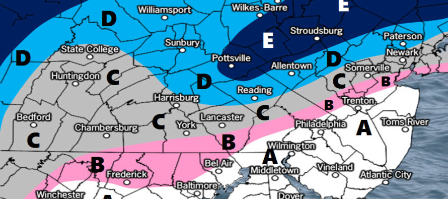
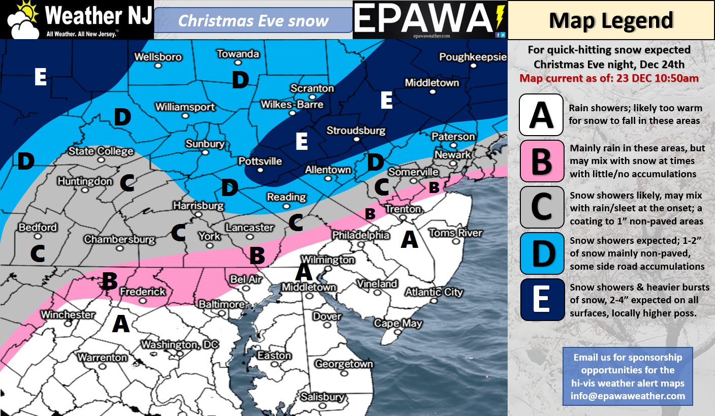
Click here for full resolution snow map!
Discussion: Once today’s warmer disturbance tracks away to our NE, two more disturbances should track parallel to the Appalachian Mountains between Sunday-Monday (Christmas Eve-Day). The low closer to the Apps will likely transfer to the coastal low once into NY State. The transfer will likely occur directly over New England. This transferring energy will likely be enhanced by a strong upper-level jet that coincides with the front side of an approaching trough. While the dynamics are there for snowfall, especially NW of the I-95 corridor, the surface temperature profile is very marginal for most of New Jersey. Therefore NWNJ is favored for wintry type precipitation and SENJ is favored for rain.
In the middle of NWNJ and SENJ (somewhere just NW of the NJTP) I expect rain to mix with snow yielding little-to-no accumulations on most roadways…perhaps trace slushy accumulations on natural surfaces. The surface boundary temperatures are simply not where they need to be for stickage along and SE of I-95/NJTP. With that said areas NW of I-95/NJTP have the best shot to see snowfall, especially Sussex and Warren Counties. We’ve been noticing some impressive jet dynamics for NEPA/NWNJ and expect this area to jackpot from this small and quick-moving system. To be clear, the lower 2/3 of NJ (S of I-78 and SE of I-287) are looking at a mostly-rain event possibly ending as a few flurries.
Timing: Precipitation could spread into SNJ as early as sunset on Sunday. Most of this area should be too warm for snow to fall and/or stick. Precipitation should then spread into the rest of NJ between early Sunday evening and midnight. I expect the last of it to end from SW to NE by early Sunday AM.
Travel Impacts: The only area I see snow falling and sticking to roadways is NW of I-287 and N of I-78 (possibly even N of I-80). This would have the biggest impact on Routes 15 and 206 (N of I-80). All major NENJ/CNJ roads S and E of that (I-95/NJTP, S of I-78, SE of I-287) will be likely subject to snow mixing into rain or possibly even periods of all snow without stickage. I see no major issues with the Garden State Parkway (South of the Raritan Bridge) or Atlantic City Expressway (between Philadelphia and AC). Possibly just a small changeover from rain to a snow/rain mix right before precipitation wraps up during early Sunday AM hours.
Next Weekend’s Winter Storm Signal: We’ve been covering this in our premium forum for quite a while now. We’re not ready to make a public forecast yet but we are closely monitoring and discussing the ~Dec 29-30 period. It won’t be until Tuesday night/Wednesday morning until upstream energy (associated with this potential) is properly sampled over western North American land (where there’s an abundance of weather sensors vs the lack-of over the Pacific Ocean). Therefore, we are not concerned with current surface model output run-to-run (what your automated forecasts populate off of). We are instead focusing on favorable teleconnection patterns and ensemble spreads as to “yay or nay” on the overall storm signal. Right now it’s still a yay considering the -EPO, MJO phase concurrent pattern and mean ensemble spreads.
In English: Tens of millions are expected to travel in our coverage region this holiday weekend. The above snow map represents our expectations between late Christmas Eve and early Christmas Day. For the lower 2/3 of New Jersey it’s a nuisance event (mostly rain possibly ending as light snowfall without sticking). NWNJ however has the best chance to squeeze out a White Christmas with light snow accumulations possible for Dec 25 daybreak. It all starts early tomorrow evening and wraps up just after midnight early on Christmas Day. We should then expect a cold week leading up the favorable winter storm signal period next weekend. Videos on such likely coming soon. Everyone have a great rest of your Saturday and please be safe! JC
For comprehensive and interactive hyper-local analysis that goes way above and beyond the detail of this public forecast, check out our premium services which include text notifications (from real forecasters for your area) and forum access (guaranteed forecaster interaction).
Jonathan Carr (JC) is the founder and sole operator of Weather NJ, New Jersey’s largest independent weather reporting agency. Since 2010, Jonathan has provided weather safety and forecasting services for New Jersey and immediate surrounding areas through the web, social media, and app spaces. Originally branded as Severe NJ Weather (before 2014), Weather NJ is proud to bring you accurate and responsible discussions ahead of high-stakes weather scenarios that impact the garden state. All Weather. All New Jersey.™


LOCAL FORECAST | INTERACTIVE RADAR | LATEST NJ WEATHER ALERTS | WEDDING FORECAST| PRIVACY POLICY
© Copyright 2024 Weather NJ LLC. All Rights Reserved.
Some information that can be found on our website is provided by a private weather station and is not an officially recognized station for weather reporting. Though we always strive to achieve accurate reporting for our own use, it is important that you do NOT depend on the data provided here for any purpose.
