

Dec 26: Possible Wintry Conditions Detected
New Jersey weather will remain unsettled through at least Tuesday night as two areas of low pressure impact our region. The first will be weaker and track to our N through this weekend. This should only bring cloudy conditions, more fog and light to moderate rainfall.
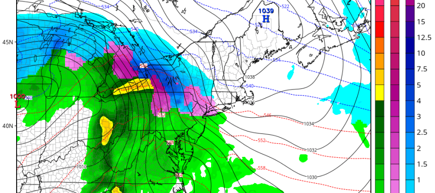
We then should have a short period between Sunday and Monday of colder temperatures where the surface of NNJ/CNJ flirts with below-freezing temperatures, especially overnight. This will be due to strong (1040mb+) high pressure to our north bringing some colder air down.
The second low pressure system is modeled stronger but will cut to our W Monday into Tuesday (into the Great Lakes). This will bring a warmer air mass with more rain back into our region from the W and S. The only wintry concern is primarily for the elevations of NWNJ but could possibly impact some lower elevations of NNJ and CNJ as well. As the rain moves in Monday PM/Tuesday AM, it could fall on a surface that is still cold from the Canadian high pressure influence.
If precipitation falls as rain and then freezes on ground contact, it will be freezing rain. If it freezes just before hitting the surface then it will be sleet. I doubt anyone will see snowfall or any snow accumulations as the mid-to-upper levels will be quickly overridden with warm air advection. The Tuesday AM commute could be a little dicey however, especially where the surface is still at or below freezing. Again, I think this will be for the elevations of NWNJ and only some of the lower elevations in NNJ and CNJ. With any luck, this will happen before Tuesday AM rush hour. SNJ and especially SENJ should expect mostly rain from this.
In English: Expect an unsettled weekend as mild temperatures (50s and 60s) continue through Sunday. Sunday night into Monday looks colder. Monday into Tuesday looks rainy with some wintry road conditions possible N of I-195 (especially N of I-78) before everything eventually changes to rain. January looks much colder than December was as the pattern chance now appears more favorable than ever. Have a great weekend and be safe! JC
This weekend outlook is proudly sponsored by weathertrends360 (www.weathertrends360.com). Through 150 years of world wide weather data analysis, weathertrends360 has developed proprietary algorithms and methods that predict weather trends up to a year with 84% accuracy. They are second to none in the long range so check them out for business planning, travel planning, etc. Also check out their free txt and email alerts!
Jonathan Carr (JC) is the founder and sole operator of Weather NJ, New Jersey’s largest independent weather reporting agency. Since 2010, Jonathan has provided weather safety and forecasting services for New Jersey and immediate surrounding areas through the web, social media, and app spaces. Originally branded as Severe NJ Weather (before 2014), Weather NJ is proud to bring you accurate and responsible discussions ahead of high-stakes weather scenarios that impact the garden state. All Weather. All New Jersey.™


LOCAL FORECAST | INTERACTIVE RADAR | LATEST NJ WEATHER ALERTS | WEDDING FORECAST| PRIVACY POLICY
© Copyright 2024 Weather NJ LLC. All Rights Reserved.
Some information that can be found on our website is provided by a private weather station and is not an officially recognized station for weather reporting. Though we always strive to achieve accurate reporting for our own use, it is important that you do NOT depend on the data provided here for any purpose.
