

Dec 29: Arctic Air Approaching!
As referenced last week, Arctic high pressure is dropping out of Canada into the US over Montana. Associated anti-cyclonic flow is pushing an Arctic cold front through the eastern US. Starting tomorrow and heading into the weekend, you’ll see the result of this via below-average temperatures. A lot of the northeast and parts of the mid-Atlantic could stay below freezing for daytime high temperatures during this Arctic air-mass invasion. Let’s look at some supporting guidance centered around New Years Eve:
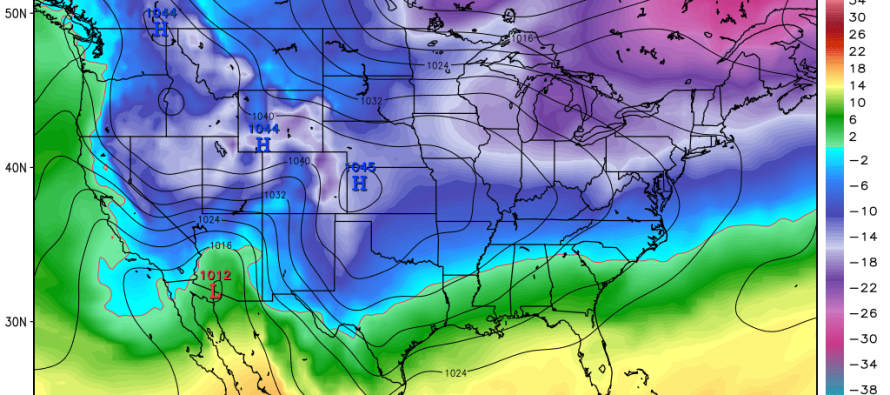
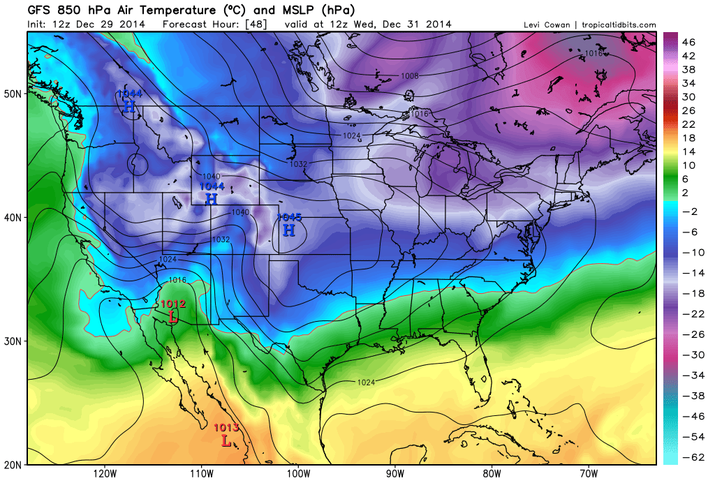
The American GFS has a 1045mb Arctic high pressure system centered over the Colorado/Nebraska/Kansas region Wednesday morning. Remember, high pressure systems are anti-cyclonic meaning the general flow around it rotates clockwise. Given this western/central US position, cold air from the north will be pulled down in front of it (to it’s east) as it moves through the US. Notice the line of freezing all the way down to the South Carolina/North Carolina region. This is the 12Z American GFS showing pressure and temperature (in Celsius) at 850mb (about 5000 feet of altitude) for late Tuesday night. The surface is generally about 5-10C warmer at the surface:
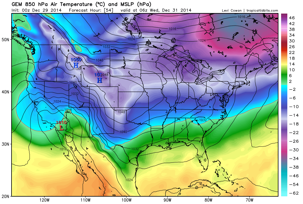
Next up is the 00Z Canadian which is slightly slower than the GFS but still advertises the same idea. Arctic high pressure (1050mb!) is dropping out of Canada over the Rockies/western plains and hurling cold air at the east coast. This is the 00Z Canadian GEM showing pressure and temperature (in Celsius) at 850mb (about 5000 feet of altitude) for early Wednesday morning. Again, note the line of freezing, at 5000ft of altitude, all the way down to NC/SC:
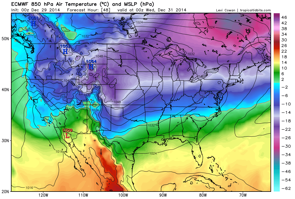
Lastly, let’s look at the 00Z European model for the same time frame. The Euro has the strongest high pressure modeled at 1054mb—an Arctic beast! The same principals advertised on the GFS and Canadian apply. Arctic high pressure drops out of Canada over the Rockies/western plains and hammers the east coast with cold air.
After the initial impact of the Arctic air mass, a low pressure disturbance will likely form in the Gulf of Mexico, ride northward towards the Ohio Valley and then transfer to the OBX/Delmarva area this Sunday-Monday. This represents the next winter storm possibility for our region that I’ll be tracking this week. We really need to wait a few days before a more confident handle can be had on this possibility. I wouldn’t be doing my duty, however, if I didn’t mention the guidance converging on the solution. I’ll have a detailed article posted tomorrow that covers all supporting guidance and the general synoptic setup.
In English: It’s going to get pretty cold starting tomorrow and lasting into the first part of the weekend. Temperatures will spend a lot of time below freezing, especially during overnight hours. A winter storm is then possible in the Sunday-Monday window that could feature all forms of precipitation (snow, sleet, freezing rain, and rain). I’ll have more on that tomorrow and will update accordingly as we approach during the week. Be safe and have a great day! JC
Model images courtesy of Tropical Tidbits.

Jonathan Carr (JC) is the founder and sole operator of Weather NJ, New Jersey’s largest independent weather reporting agency. Since 2010, Jonathan has provided weather safety and forecasting services for New Jersey and immediate surrounding areas through the web, social media, and app spaces. Originally branded as Severe NJ Weather (before 2014), Weather NJ is proud to bring you accurate and responsible discussions ahead of high-stakes weather scenarios that impact the garden state. All Weather. All New Jersey.™


LOCAL FORECAST | INTERACTIVE RADAR | LATEST NJ WEATHER ALERTS | WEDDING FORECAST| PRIVACY POLICY
© Copyright 2024 Weather NJ LLC. All Rights Reserved.
Some information that can be found on our website is provided by a private weather station and is not an officially recognized station for weather reporting. Though we always strive to achieve accurate reporting for our own use, it is important that you do NOT depend on the data provided here for any purpose.
