

Dec 29: Final Call Snow Map for Saturday (Tomorrow)
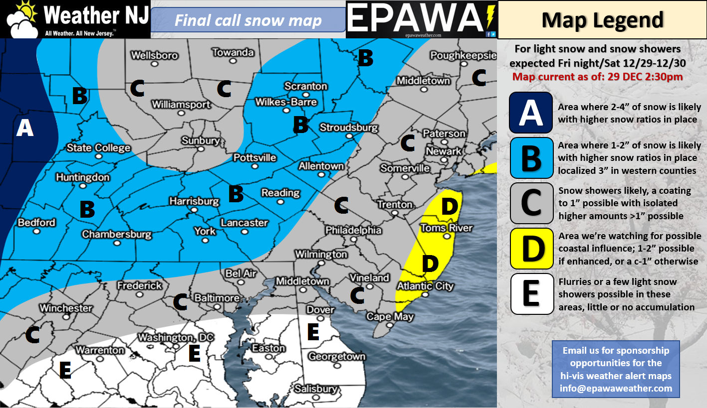
Click here for full-resolution snow map!
Discussion: No real changes to last night’s forecast. Snowfall is currently approaching the Ohio Valley region. This should spread through PA and N MD overnight before exiting across NJ tomorrow. Timing is between dusk and dawn tomorrow for NJ from the W to E moving shield of precipitation. End-game accumulations are on the lighter side as the above map suggests.
The current temperature profile however will allow for high-ratio snowfall that should stick to all surfaces. It only takes a half-inch of this fluffy kind of stuff to make untreated roads slippery. This should be the kind of snow that’s swept away with a broom. For most.
There is one wildcard area that’s worth mentioning (yellow area). A weak surface low is expected to form somewhere in the Delmarva/SNJ area tomorrow as remaining northern energy pulls away. This is expected to enhance a few departing snow bands. These bands could set up over SENJ or just offshore. Should the former occur then you could probably add an inch or two to the widespread C-1/2″ expectation. Areas SE of the I-95 corridor/NJTP would be favored with immediate coastal regions (yellow area) the most favored for such. My gut feel is about a 20-30% chance of this happening…therefore I feel that a 70-80% chance exists of just the widespread coating to an inch or two. This will have to be now-casted as it happens.
In English: A very light and fluffy snowfall is on the way. Snowfall should begin by daybreak tomorrow and end by late-afternoon. Only a coating to an inch or two is expected so nothing too disruptive. A small wildcard chance exists that SENJ counties could see a little more due to coastal enhancement. Otherwise this isn’t a big deal. Please use a little extra caution on any untreated snow-covered roadways tomorrow. The above map represents our most reasonable evidence-based expectation heading into this light event. Live observations from this point on. Have a great night and please be safe! JC
For comprehensive and interactive hyper-local analysis that goes way above and beyond the detail of this public forecast, check out our premium services which include text notifications and forum access.
Jonathan Carr (JC) is the founder and sole operator of Weather NJ, New Jersey’s largest independent weather reporting agency. Since 2010, Jonathan has provided weather safety and forecasting services for New Jersey and immediate surrounding areas through the web, social media, and app spaces. Originally branded as Severe NJ Weather (before 2014), Weather NJ is proud to bring you accurate and responsible discussions ahead of high-stakes weather scenarios that impact the garden state. All Weather. All New Jersey.™


LOCAL FORECAST | INTERACTIVE RADAR | LATEST NJ WEATHER ALERTS | WEDDING FORECAST| PRIVACY POLICY
© Copyright 2024 Weather NJ LLC. All Rights Reserved.
Some information that can be found on our website is provided by a private weather station and is not an officially recognized station for weather reporting. Though we always strive to achieve accurate reporting for our own use, it is important that you do NOT depend on the data provided here for any purpose.

)