

Dec 31: Weekend Storm Update
First, on behalf of Weather NJ, I’d like to wish you all a safe and happy new year! To the people who have been standing outside in NYC and will continue to stand outside through midnight, I don’t need to tell you that it’s going to be a cold one. My best advice is to use penguin cuddling techniqueto stay warm in numbers. To everyone as we close out 2014, I lift my wine glass in celebration with the best weather fan-base on the planet. As my uncle used to say, “May your coffins be made of 100-year old trees planted tomorrow.” Cheers!
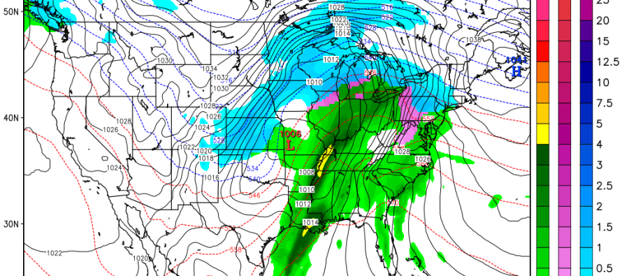
Now lets look at the low pressure disturbance that will be tracking through the US this weekend. Low pressure will move into the NW US off the Pacific Ocean and represent the northern energy. Another area of low pressure will form in the Texas area representing the southern energy. These two lows will merge into a single low pressure disturbance in the W Tennessee/W Kentucky region and track into the E Great Lakes—aka a Great Lakes Cutter. This obviously places New Jersey on the warmer side of the storm meaning mostly rain and above freezing temperatures.
The only part of the storm that I’m concerned about wintry weather for is the initial onset of precipitation. I would only give this scenario a 30% chance of verifying. It’s just something to watch out for given the impact it could have on untreated roads and other heavily used surfaces. A much better understanding of surface temperature profile will be had on Saturday morning. Warm air will first be invading the upper levels of the atmosphere. This could trap below freezing temperatures in the lower levels of the atmosphere, especially at the base of the Appalachian Mountains. With that being said, NWNJ, and possibly some parts of CNJ and NENJ, could see snow, sleet, and/or freezing rain for a short period before turning over to all rain. Eventually all levels of the atmosphere will be above freezing with rain. Most everyone SE of the I-95 corridor will likely see all rain from start to finish. This is the 12Z Canadian GEM showing parts of NNJ starting as snow Saturday evening. The Euro shows a similar solution to the Canadian and the GFS is all rain from start to finish. As you can see, this would be much more of an issue for NE PA. Again, just a 30% chance of this before everyone sees all rain and above freezing temperatures. It all clears out by Sunday evening.
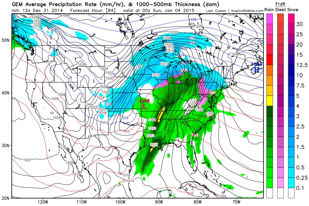
In English: We’re cold through Saturday morning then precipitation moves in from the south by Saturday evening. There’s a small chance it starts wintry before changing over to all rain and clearing out by Sunday evening. Please be safe and have a happy new year! JC

Jonathan Carr (JC) is the founder and sole operator of Weather NJ, New Jersey’s largest independent weather reporting agency. Since 2010, Jonathan has provided weather safety and forecasting services for New Jersey and immediate surrounding areas through the web, social media, and app spaces. Originally branded as Severe NJ Weather (before 2014), Weather NJ is proud to bring you accurate and responsible discussions ahead of high-stakes weather scenarios that impact the garden state. All Weather. All New Jersey.™


LOCAL FORECAST | INTERACTIVE RADAR | LATEST NJ WEATHER ALERTS | WEDDING FORECAST| PRIVACY POLICY
© Copyright 2024 Weather NJ LLC. All Rights Reserved.
Some information that can be found on our website is provided by a private weather station and is not an officially recognized station for weather reporting. Though we always strive to achieve accurate reporting for our own use, it is important that you do NOT depend on the data provided here for any purpose.
