

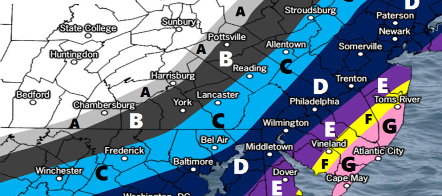
Dec 8: Final Call Snow Map for Saturday

Click here to see full resolution snow map!
Discussion: The 250mb jet streak over our region continues to impress for this event. This should help enhance frontogenic forcing/lifting below at the 700mb level which translates to heavier snow rates at the surface. Google upper air divergence and difluence if you wish to take a deeper dive into the physics. 500mb analysis of the two shortwaves involved (northern and southern stream) has held since yesterday. The southern stream remains slower which allows 500mb height anomalies to build over the ocean and tilt the thermal gradient/boundary out in the ocean (and entire trough once phased for that matter) towards a neutral tilt. This allows the coastal surface low to pass closer to the coast with greater intensity than what was modeled earlier this week.
We’ve bumped totals for the jackpot zones and extended the NW side of precipitation further to the NW to adjust for said dynamics. We still think there could be mixing issues along the NJ coast hence our pink area expectations. If you are in areas C, D, E, and F I would put the plows on to be safe if you are a contractor. Zone G will likely see less accumulations on roads, especially treated major roads like the Garden State Parkway and eastern side of the Atlantic City Expressway. With most snowfall expected to occur during warmer daylight hours tomorrow, road accumulations will be battling both seasonal climatology and a marginal boundary layer. Any snow that falls overnight tonight and after sunset tomorrow would have a better chance of stickage due to the 20-30F environment unlike tomorrow afternoon when temps could climb into the lower-30s fro SE parts.
Timing: The coastal low will be tracking from SW to NE about 250-300 miles offshore between Saturday morning and Saturday night. As it does so from OBX through the 40N/70W benchmark, it’s central low pressure should drop from about 1000mb to 995mb. There are no indications of a stall, bomb-out or retrograde so it should be a fairly straightforward system. The significant precipitation should arrive from S/SE to N/NW during the early AM hours of Saturday. Flurries and initial snow showers have already begun in SNJ/SENJ but the core precipitation is still expected during tomorrow with the passing low. The precipitation shield should peak in NW extent somewhere between State College, PA and Allentown, PA tomorrow afternoon before everything pulls away and tapers off from W to E between Saturday evening and possibly the early AM hours of Sunday. Cold, dry and gusty NW winds should then ensue through at least most of Sunday.
Coastal Impacts: Coastal concerns have not changed since yesterday’s first call snow map article. An upper-end of minor to lower-end of moderate risk for coastal flooding exists surrounding the noon-ish high tide on Saturday. Nothing crazy but a slight rise due to the sub-1000mb low pushing some water towards the coast.
In English: The above map represents expected total snow accumulations on natural surfaces. Paved surfaces should match natural surface expectations in zones B, C and D. Zones E, F and G will likely feature less accumulations on paved surfaces especially in zones G. Zones E and F could go either way depending on snowfall intensity. Most significant snowfall should take place between midnight tonight and tomorrow evening despite the flurry/snow shower action some of you in SNJ/SENJ are already seeing now. SENJ has the best chance for mixing and marginal surface temperatures that may hold down accumulations. Once precipitation moves offshore by Saturday night, temperatures should fall and NW winds should pick up through Sunday. There are a few other snowy possibilities next week including a clipper or two surrounding a very cold Wednesday. There are also long-range signals for a larger system in the Dec 17-19 period but let’s take one system at a time. Everyone have a great night and please be safe! JC
For comprehensive and interactive hyper-local analysis that goes way above and beyond the detail of this public forecast, check out our premium services.
Jonathan Carr (JC) is the founder and sole operator of Weather NJ, New Jersey’s largest independent weather reporting agency. Since 2010, Jonathan has provided weather safety and forecasting services for New Jersey and immediate surrounding areas through the web, social media, and app spaces. Originally branded as Severe NJ Weather (before 2014), Weather NJ is proud to bring you accurate and responsible discussions ahead of high-stakes weather scenarios that impact the garden state. All Weather. All New Jersey.™


LOCAL FORECAST | INTERACTIVE RADAR | LATEST NJ WEATHER ALERTS | WEDDING FORECAST| PRIVACY POLICY
© Copyright 2024 Weather NJ LLC. All Rights Reserved.
Some information that can be found on our website is provided by a private weather station and is not an officially recognized station for weather reporting. Though we always strive to achieve accurate reporting for our own use, it is important that you do NOT depend on the data provided here for any purpose.
