

Dry Start. Wet and Windy Finish (Feb 26-Mar 2)
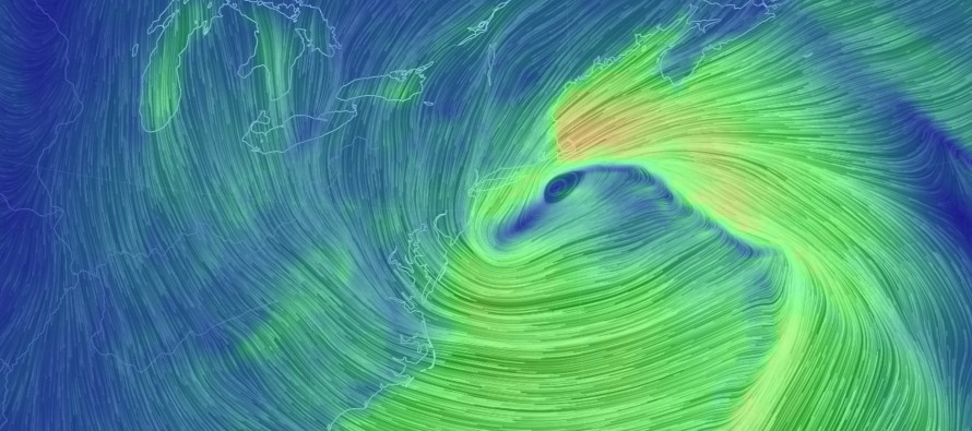
Discussion: Monday through Thursday AM is fairly straight-forward. Passing high pressure should have complete control of the region underneath a building ridge of upper-level heights. This means dry, sunny and relatively mild weather for NJ from Monday through Thursday morning. From Thursday afternoon through early Saturday morning is complicated. An upper-level shortwave, with an associated surface low, should track directly from the SW US towards the Great Lakes. This energy should then bounce off the ridiculously-strong blocking signal (-NAO) and reform somewhere in the SE PA, Delmarva, SNJ area before stalling, possibly retrograding slightly, and eventually pulling away. Snow is my last concern with this Thursday PM-Saturday AM system. I care more about the full moon, potentially heavy rainfall, and possible wind-driven storm surge. I think the best chance for that is Thursday night into Friday afternoon. Once the winds rock in-direction around the cyclone, they will become northerly and less of a flooding factor for the coast. We’re then likely still on the hook for rainfall and N winds through early Saturday morning. A nor’easter in a nutshell IMO due to the stall/retrograde potential. The rest of the weekend then looks dry and windy (from Saturday morning through Sunday). You will probably see some event-specific posts from me this week about the Thursday PM-Saturday AM nor’easter.
Monday (Feb 26) high temperatures should reach into the 50s statewide. Skies should transition from partly-to-mostly sunny. Winds should be light out of the W/NW. Overnight lows should range from mid-20s to mid-30s NNJ to SNJ.
Tuesday (Feb 27) high temperatures should reach into the mid-50s statewide. A few interior CNJ/SNJ locations could flirt with 60. Skies should be mostly sunny. Winds should be light out of the W/SW. Overnight lows should range from near-30 to near-40 NNJ to SNJ.
Wednesday (Feb 28) high temperatures should reach into the mid-50s statewide. This is probably the best chance of the week to break into the 60s away from the ocean in CNJ/SNJ. Skies should be mostly sunny. Winds should be light out of the SW. Overnight lows should range from mid-30s to mid-40s NNJ to SNJ.
Thursday (Mar 1) high temperatures should struggle to reach 50. Skies should start partly cloudy but increase in cloud coverage fairly quickly. Rainfall is possible as early as noon and should continue through evening and overnight hours. Winds should increase out of the SE. Overnight lows should fall to into the low-40s for most. I’m watching the possibility of coastal flooding for this period (rain + onshore flow + Mar 2 full moon).
Friday (Mar 2) high temperatures should be held in the 40s again statewide. Skies should be mostly cloudy. More rainfall is likely for most of the day with increased winds becoming more northerly. Overnight lows should range from upper-30s to lower-40s NNJ to SNJ. Precipitation should cut-off overnight.
An early look at the weekend indicates colder and drier conditions. Rain (maybe flurries for some) should taper off early on Saturday. At this point the departing coastal storm should be fairly strong. That should mean strong and dry N winds behind it for our region Saturday night into Sunday. I would expect winds to begin subsiding by Sunday night as the low moves completely out of range out to sea. You will probably see some event-specific posts from me this week about the Thursday PM-Saturday AM system. Have a great week and please be safe! JC
For comprehensive and interactive hyper-local analysis that goes way above and beyond the detail of this public forecast, check out our premium services which include hyper-local text notifications from and guaranteed forum discussion with myself and Eastern PA Weather Authority (EPAWA).
Jonathan Carr (JC) is the founder and sole operator of Weather NJ, New Jersey’s largest independent weather reporting agency. Since 2010, Jonathan has provided weather safety and forecasting services for New Jersey and immediate surrounding areas through the web, social media, and app spaces. Originally branded as Severe NJ Weather (before 2014), Weather NJ is proud to bring you accurate and responsible discussions ahead of high-stakes weather scenarios that impact the garden state. All Weather. All New Jersey.™


LOCAL FORECAST | INTERACTIVE RADAR | LATEST NJ WEATHER ALERTS | WEDDING FORECAST| PRIVACY POLICY
© Copyright 2024 Weather NJ LLC. All Rights Reserved.
Some information that can be found on our website is provided by a private weather station and is not an officially recognized station for weather reporting. Though we always strive to achieve accurate reporting for our own use, it is important that you do NOT depend on the data provided here for any purpose.

)