

Feb 10: System Two Update

Click here to view full resolution map!
Click here to view full resolution map!
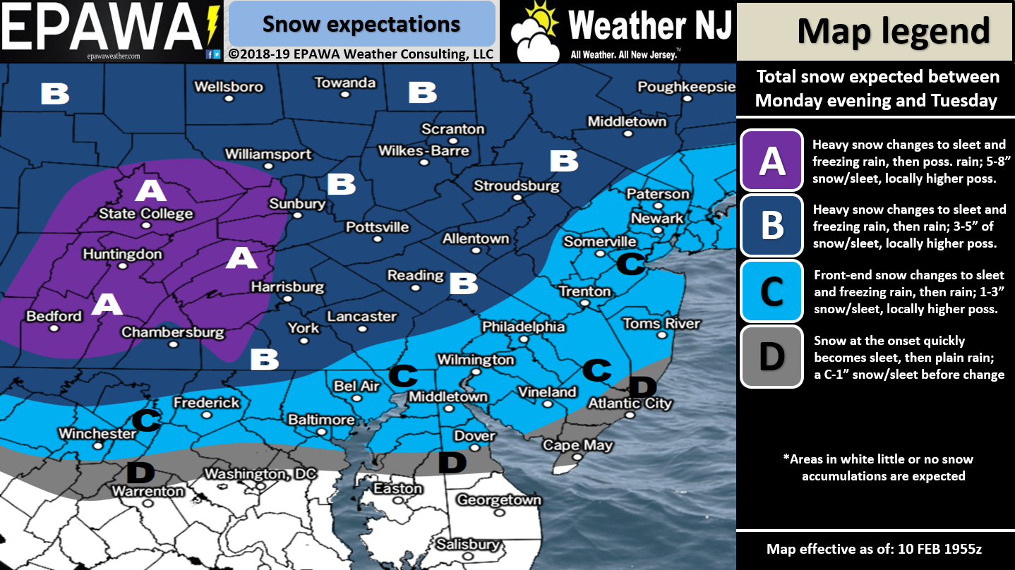
Discussion: Since this second system features both snow and ice we’ve separated the impact maps accordingly above. System one should finish up by mid-to-late morning tomorrow (Monday). System two should then begin as early as 4pm Monday—just ~6-8 hours later. Now make no mistake. By Tuesday morning most of NJ will see snow change over to rain. Areas NW of I-95/NJTP have the best chance to see sleet and/or freezing rain before changing to all rain. Only NWNJ elevations have the chance to remain wintry until precipitation ends completely later Tuesday night. Above-540dam 500mb height anomalies and strong 700mb/850mb flow will ensure the warming of the mid-layers. The wildcard surprise potential would be the 925mb/surface layers holding onto cold longer. This would simply mean more ice than rain. The snow making is killed with the warmer mid-layers.
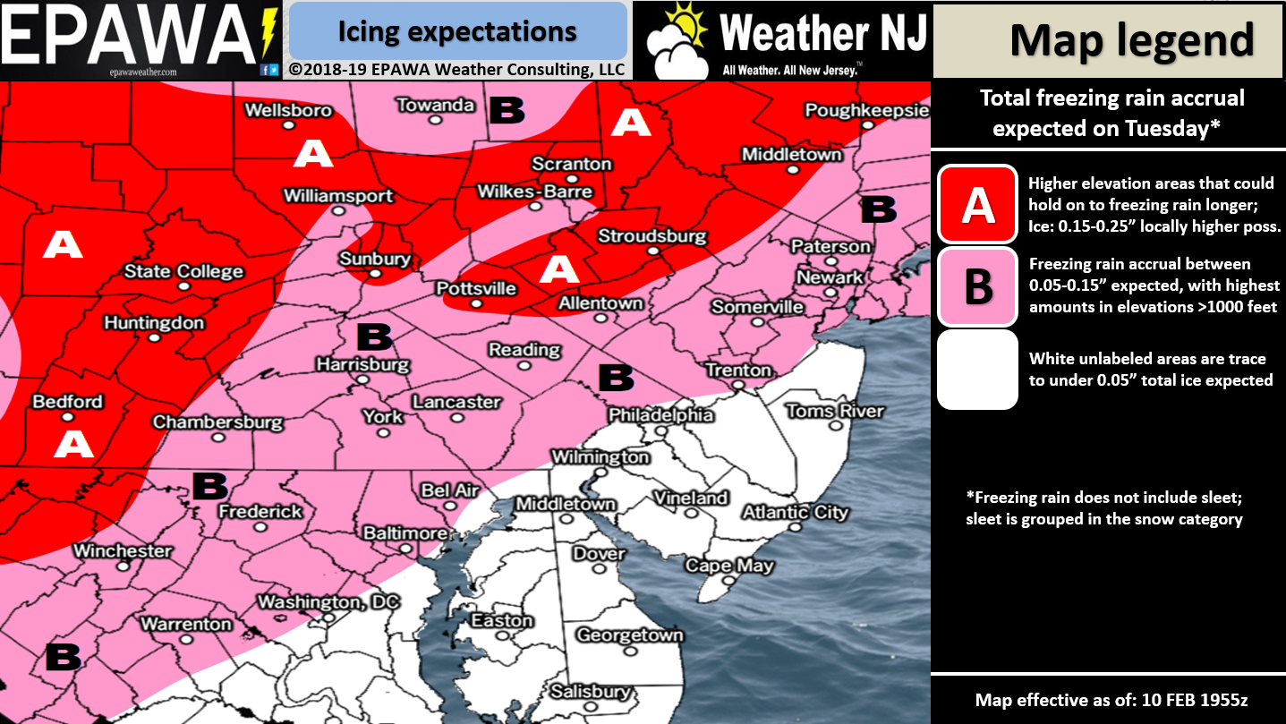
Accumulating snowfall is possible from 4pm tomorrow (Monday) through about 4am Tuesday. The snow map above shows how much should fall in that period. From 4am-forward on Tuesday snow should change to rain from S to N. For all areas along and SE of I-95/NJTP it should be a quick change from snow to rain with little-to-no ice. For areas NW of I-95/NWNJ the above ice map shows how much ice accrual should occur before changing to rain.
Precipitation should end between late-Tuesday night and early Wednesday morning. Given how intense the warm sector will be it is possible this all ends with convective precipitation along the ending cold front. That could mean a few thunderstorms embedded within the frontal passage precipitation. So if you wake up to some rumbles overnight (Tuesday PM into Wednesday AM) don’t be surprised.
In English: Expect more snow between about 4pm tomorrow (Monday) and just after midnight (Tuesday morning). Expect snow to change to rain from S to N on Tuesday morning. NWNJ (NW of I-95/NJTP) could see ice on Tuesday between the transition in the form of sleet and/or freezing rain. The above impact maps show the amount of snow first expected and then ice between. Most of NJ should be over to all rain for most of Tuesday. Boomers could finish it all up by early Wednesday. The Tuesday AM commute could be messy especially for the expected icy areas. Download the new free Weather NJ mobile app on Apple and/or Android. It’s the easiest way to never miss Weather NJ content. Have a great rest of your Sunday and please be safe! JC
Jonathan Carr (JC) is the founder and sole operator of Weather NJ, New Jersey’s largest independent weather reporting agency. Since 2010, Jonathan has provided weather safety and forecasting services for New Jersey and immediate surrounding areas through the web, social media, and app spaces. Originally branded as Severe NJ Weather (before 2014), Weather NJ is proud to bring you accurate and responsible discussions ahead of high-stakes weather scenarios that impact the garden state. All Weather. All New Jersey.™


LOCAL FORECAST | INTERACTIVE RADAR | LATEST NJ WEATHER ALERTS | WEDDING FORECAST| PRIVACY POLICY
© Copyright 2024 Weather NJ LLC. All Rights Reserved.
Some information that can be found on our website is provided by a private weather station and is not an officially recognized station for weather reporting. Though we always strive to achieve accurate reporting for our own use, it is important that you do NOT depend on the data provided here for any purpose.
