

Feb 13: Weekend Winter Storm Update
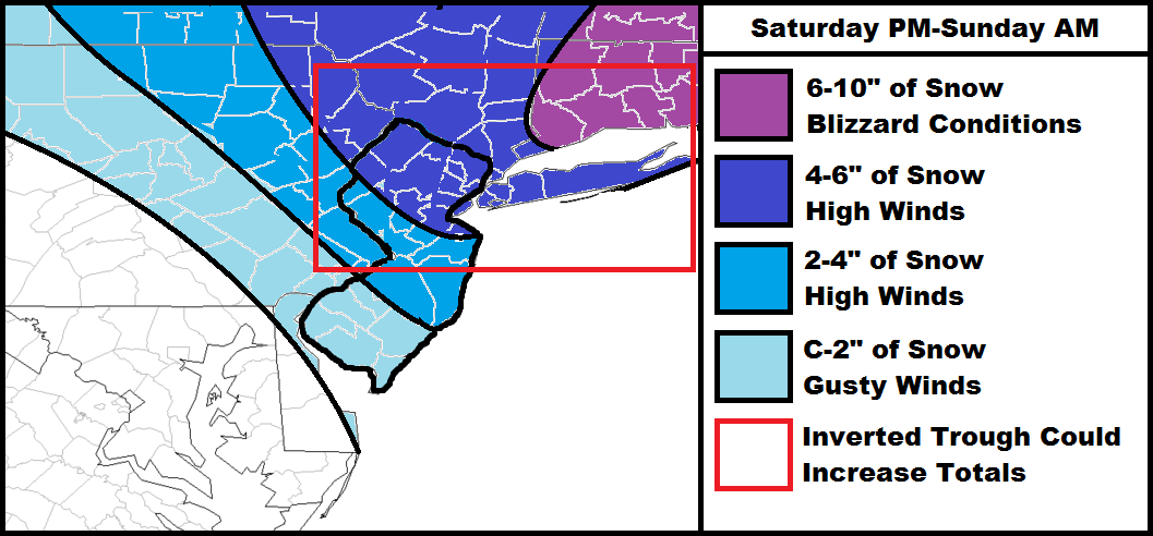
We’re now under 24 hours away from winter storm impact in New Jersey. The clipper is riding in from the NW and will transfer to the ocean near Delmarva/SNJ tomorrow evening. It will then bomb out and give coastal New England yet another blizzard but not before dropping minor to significant snowfall across New Jersey and the NYC metropolitan area.
I’m liking where my map is from last night so I’m just going to roll with it for now. If overnight guidance trends differently I will adjust for tomorrow’s final call. Otherwise, I think we’re, for the most part, locking into a solution. So the above map, from yesterday, stands as called. Timing for NJ looks like tomorrow afternoon/evening through Sunday morning. I expect peak snowfall time to be between 9PM tomorrow night and 5AM Sunday morning. The map still has the red area to account for the small chance of over-performance from the inverted trough.
I would like to re-emphasize that northerly winds will be strong tomorrow night into Sunday with gusts to 50mph, especially along the coast. Also, temperatures will be extremely cold during and especially after the snowfall. Downed trees and power lines will likely lead to power outages. Gas up your generators, make sure pets are inside, etc…do what you have to do tomorrow before afternoon.
In English: Strong winds, cold temperatures, and minor to significant accumulations are likely tomorrow night through Sunday morning. The map is pretty straight forward. Bitter cold Arctic air will follow the snow for Sunday and Monday. Please stay warm and be safe! JC
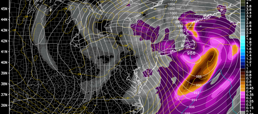
Model image used with permission with WeatherBell Analytics.
Jonathan Carr (JC) is the founder and sole operator of Weather NJ, New Jersey’s largest independent weather reporting agency. Since 2010, Jonathan has provided weather safety and forecasting services for New Jersey and immediate surrounding areas through the web, social media, and app spaces. Originally branded as Severe NJ Weather (before 2014), Weather NJ is proud to bring you accurate and responsible discussions ahead of high-stakes weather scenarios that impact the garden state. All Weather. All New Jersey.™


LOCAL FORECAST | INTERACTIVE RADAR | LATEST NJ WEATHER ALERTS | WEDDING FORECAST| PRIVACY POLICY
© Copyright 2024 Weather NJ LLC. All Rights Reserved.
Some information that can be found on our website is provided by a private weather station and is not an officially recognized station for weather reporting. Though we always strive to achieve accurate reporting for our own use, it is important that you do NOT depend on the data provided here for any purpose.
