

Feb 14: Watching Weekend Snow Potential
Discussion: Passing scattered rain showers with isolated downpours are possible overnight tonight followed by a very mild Thursday into Friday. We’re talking highs into the 60s. More rain showers are expected Friday ahead of the cold front but then we drop. Even the surface should be below freezing all the way to the SENJ coast by midnight Friday night. Overnight lows should bottom out between 15-25F NNJ to SNJ by the early hours of Saturday morning. So that we all understand and are on the same page, this wipes out the idea that “it can’t snow because of how warm Thursday and Friday were.” By Saturday morning it’s cold enough at all levels, including the surface, for snow to fall and stick.
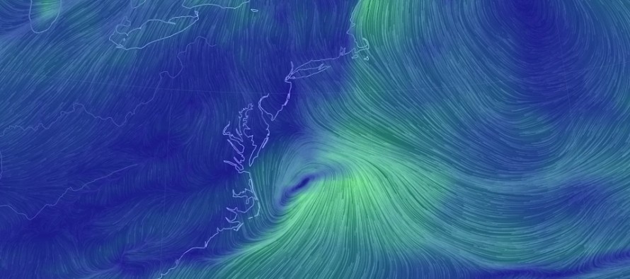
The warmer temperature issues come from the N flow ahead of the low pushing the frontal boundary back to the NW into SENJ, possibly all the way back into I-95. How far this boundary makes it into NJ will likely dictate the snow/rain line. With that said, those in NJ along and NW of I-95 are more favored for snowfall to stick. With the lack of true Arctic air, snow ratios would likely be close to 10:1. The SENJ area that saw the January 3-4 jackpot of 14-18 inches would therefore be the least favored for accumulating snowfall.
The setup is very progressive and relies on two pieces of fast-moving energy to interact. It’s an absolute thread the needle situation. Given the speed of the flow and marginal temperature setup during precipitation, I’m leaning towards light-to-significant accumulations for the jackpot zone, not double-digit accumulations. We would need to see major amplification between now and Saturday for the major accumulation category to even be considered.
Models have been pretty consistent with a timing window of Saturday PM-Sunday AM. This would remove the creeping sun-angle that this time of year offers during daylight hours. Tomorrow we will release our first-call impact map which will indicate our expected jackpot zone, accumulations and timing. For now, you know that I’m watching and where I’m currently leaning.
In English: Expect an unseasonably mild period through most of Thursday and into Friday. Rain showers are possible overnight tonight and Friday morning. By Friday night the entire state will no longer be “too warm for snow” as a cold front passes through and brings low temperatures down to the teens and 20s. A weak coastal low is then expected to bring precipitation to the area between Saturday evening and Sunday morning. Those in NJ along and NW of I-95 have the best chance to see accumulating snow. Those in NJ to the SE of I-95 have the best chance to see a snow/rain mix or just plain rain, especially along the coast. If SENJ is going to be too warm for snow during this event, it will be from the onshore flow generated by the coastal low, not from “but it’s going to be 60+ Thursday and Friday.” We should have our first call out tomorrow. Have a great night and please be safe! JC
For comprehensive and interactive hyper-local analysis that goes way above and beyond the detail of this public forecast, check out our premium services which include text notifications and forum access.
Jonathan Carr (JC) is the founder and sole operator of Weather NJ, New Jersey’s largest independent weather reporting agency. Since 2010, Jonathan has provided weather safety and forecasting services for New Jersey and immediate surrounding areas through the web, social media, and app spaces. Originally branded as Severe NJ Weather (before 2014), Weather NJ is proud to bring you accurate and responsible discussions ahead of high-stakes weather scenarios that impact the garden state. All Weather. All New Jersey.™


LOCAL FORECAST | INTERACTIVE RADAR | LATEST NJ WEATHER ALERTS | WEDDING FORECAST| PRIVACY POLICY
© Copyright 2024 Weather NJ LLC. All Rights Reserved.
Some information that can be found on our website is provided by a private weather station and is not an officially recognized station for weather reporting. Though we always strive to achieve accurate reporting for our own use, it is important that you do NOT depend on the data provided here for any purpose.
