

Feb 16: Snow Storm Approaching!
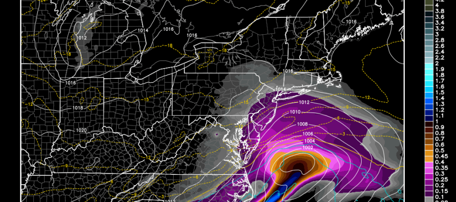
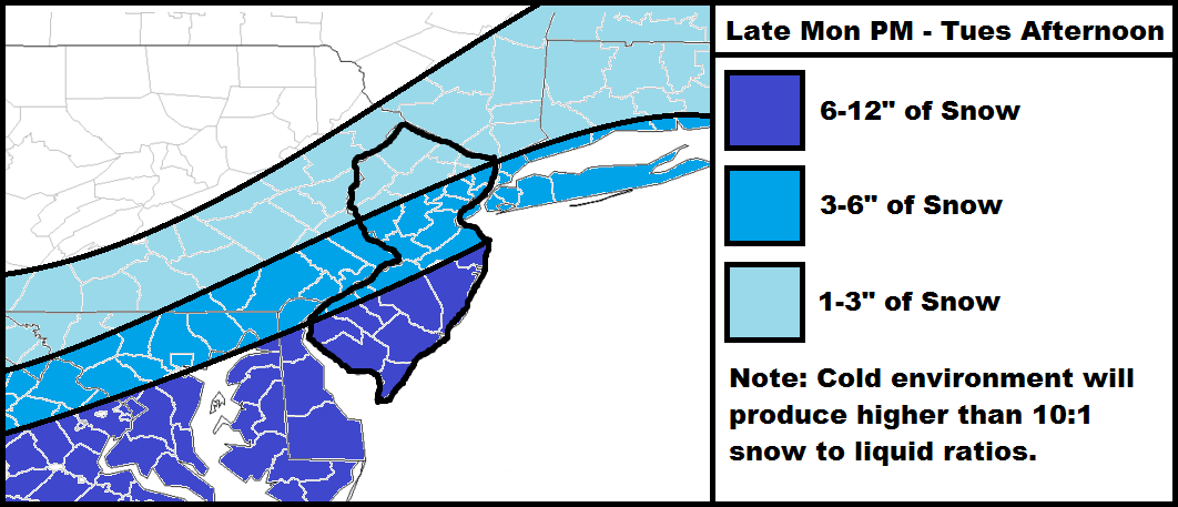
I’m going to keep it nice and simple. A low pressure system will be moving across the SE US and ejecting into the Atlantic Ocean near OBX. It will then take a track SE of the benchmark (40N/70W) before moving out to sea. As it passes by late tonight through tomorrow afternoon, it will bring Gulf of Mexico moisture northward that will combine with Atlantic Ocean moisture. This moisture will be thrown into the incredibly cold air mass currently in place. It’s a recipe for a classic New Jersey snow storm that performs better for SNJ/SENJ/Coastal NJ than points NW. In this case, I think I-95 will divide the less impacting minor accumulations to the NW from the more significant accumulations to the SE. There’s not much to slow this storm down so we’re looking at an 8-12 hour period of snowfall at most. However, we’re going to be very cold during precipitation which should yield higher than 10:1 snow ratios. The map is pretty straightforward as no mixing or rain issues will occur.
Timing: The current radar looks pretty juicy to our W/SW. I expect precipitation to move in slightly before midnight (as early as 9PM) from the W/SW and spread throughout all of New Jersey overnight. By sunrise, the entire state should be under snowfall with the western edge approaching. I expect precipitation to taper off by late-morning or early-afternoon.
In English: I expect the above map to happen between late tonight and early tomorrow afternoon. Temperatures will be very cold during this period of snowfall but winds shouldn’t be that bad. Expect brutal cold to return afterwards. Please be safe! JC
Jonathan Carr (JC) is the founder and sole operator of Weather NJ, New Jersey’s largest independent weather reporting agency. Since 2010, Jonathan has provided weather safety and forecasting services for New Jersey and immediate surrounding areas through the web, social media, and app spaces. Originally branded as Severe NJ Weather (before 2014), Weather NJ is proud to bring you accurate and responsible discussions ahead of high-stakes weather scenarios that impact the garden state. All Weather. All New Jersey.™


LOCAL FORECAST | INTERACTIVE RADAR | LATEST NJ WEATHER ALERTS | WEDDING FORECAST| PRIVACY POLICY
© Copyright 2024 Weather NJ LLC. All Rights Reserved.
Some information that can be found on our website is provided by a private weather station and is not an officially recognized station for weather reporting. Though we always strive to achieve accurate reporting for our own use, it is important that you do NOT depend on the data provided here for any purpose.
