

Feb 16: Tuesday Morning Observations

A lot of rain is about to fall between now and afternoon hours. The low is tracking through PA from S/SW to N/NE towards interior New England. As it does so, a very heavy band of precipitation will move through New Jersey with mild temperatures and gusty southerly winds. Here’s the latest radar:
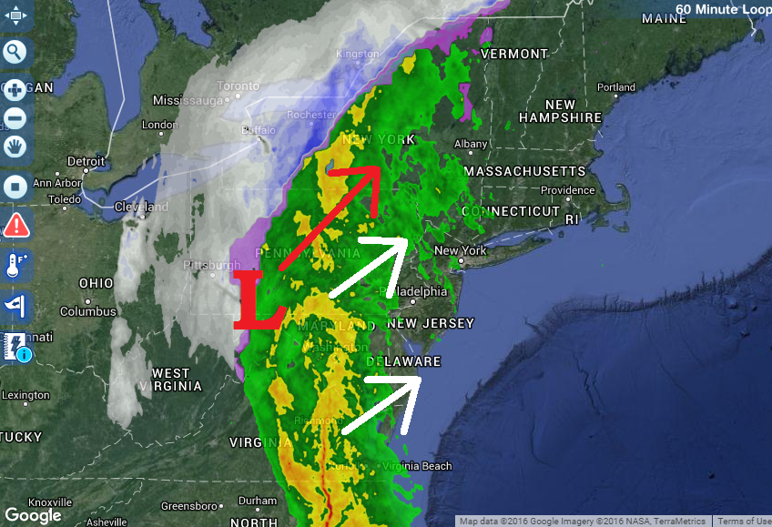
All remaining precipitation should fall in the form of rain. Expect 1-2 inches of rainfall over just a few hour period sometime between now and about 4PM. This should present flooding issues for areas of poor drainage. Sustained winds of 15-25mph with gusts to 40-50mph are possible out of the S/SW until the rain is through. I wouldn’t be surprised to see a few embedded thunderstorms within the heaviest areas of rainfall. We then taper off and dry out this evening.
Moving forward, light rain/snow is possible tomorrow morning from the remnants of a trailing clipper. We’re then looking at a mild close to the week. Long range guidance, especially ensembles, are screaming winter storm in the February 23-25 period. I’ll touch more on both tomorrow’s light snow event and long-range potential this evening. Tomorrow morning, I’ll put out a detailed 5-day forecast that will get us through the weekend.

In English: Heavy rain with gusty southerly winds should occur between now and afternoon hours. We then dry out tonight but could see some light snow and/or rain tomorrow. The weekend looks mild and clear but we now begin tracking a possible late-February winter storm showing on long-range model guidance for the February 23-25 period. Have a great day and be safe! JC
Jonathan Carr (JC) is the founder and sole operator of Weather NJ, New Jersey’s largest independent weather reporting agency. Since 2010, Jonathan has provided weather safety and forecasting services for New Jersey and immediate surrounding areas through the web, social media, and app spaces. Originally branded as Severe NJ Weather (before 2014), Weather NJ is proud to bring you accurate and responsible discussions ahead of high-stakes weather scenarios that impact the garden state. All Weather. All New Jersey.™


LOCAL FORECAST | INTERACTIVE RADAR | LATEST NJ WEATHER ALERTS | WEDDING FORECAST| PRIVACY POLICY
© Copyright 2024 Weather NJ LLC. All Rights Reserved.
Some information that can be found on our website is provided by a private weather station and is not an officially recognized station for weather reporting. Though we always strive to achieve accurate reporting for our own use, it is important that you do NOT depend on the data provided here for any purpose.
