

Feb 19: Weekend Storm Update
First and foremost, prepare for a very cold overnight period tonight. The Arctic front is well out to sea and Arctic high pressure will re-enforce the cold air mass through Saturday morning. We’re looking at single-digit lows (if not lower) with wind chills of zero to negative 10 degrees. Make sure your loved ones who require extra care are okay, make sure any vulnerable pets are inside, drip the faucets, etc. This will likely be the coldest air mass yet this season.
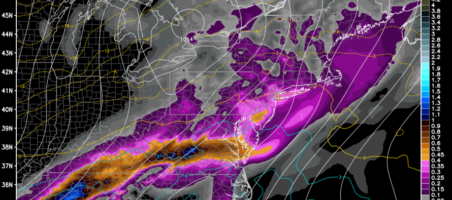
Today’s models have trended slightly colder than overnight guidance. The low pressure track has held pretty consistent (to our NW) but the precipitation shield is indicating more snow for NJ up front followed by an icy transition to rain. With that being said, this map reflects my current thoughts:
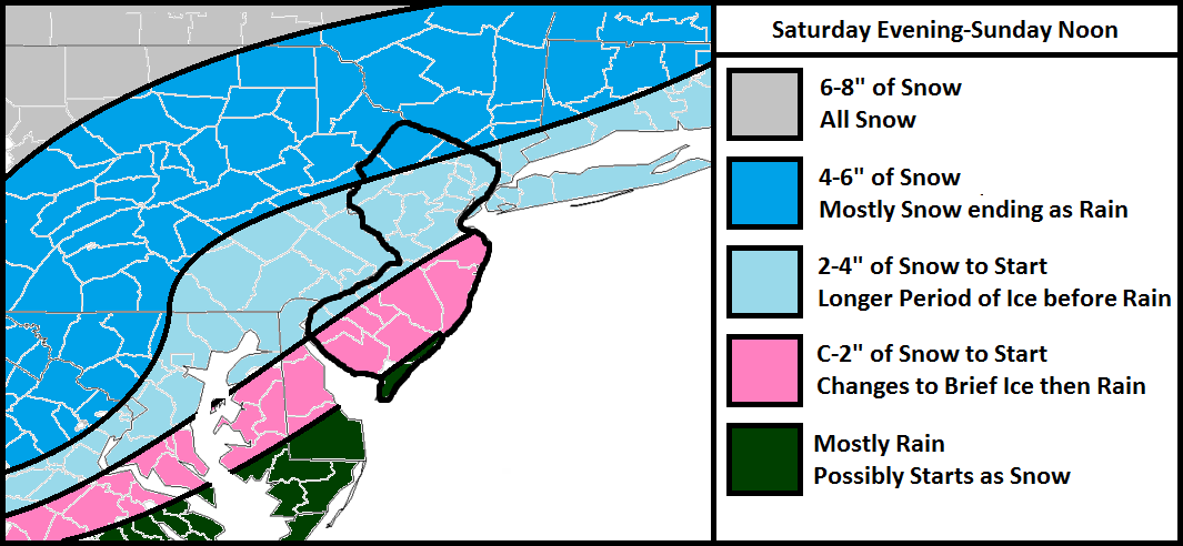
The light gray area is pretty straight-forward. It will be cold enough for all snow given it’s relevant location to the low but well to our NW.
The darker blue area should stay snowy the longest and only areas in the SE half of it “should” transition to rain towards the tail end of the system. For this reason, this area has the highest expected accumulations. I expect only a small period of sleet/freezing rain during the tail-end transition.
The lighter blue area should still see a decent front-end snow thump but should feature a longer transition to rain—naturally creating a longer duration of sleet and/or freezing rain between the snow and rain.
The pink area, like the lighter blue area, should still see a decent front-end snow thump but should feature an even longer transition to rain—again naturally creating a longer duration of sleet and/or freezing rain between the snow and rain.
The green area could start with flurries/light snow but should change over to mostly rain.
Cold Air Damming (CAD) should be minimal since a departing high pressure system (the one that’s currently re-enforcing the cold) will be providing warmer southerly flow on Saturday. Also, once the low approaches, the flow will switch to the SW (parallel to the Appalachian Mountains). This will help erode the colder layers but not all of it. The surface should hold onto just enough of a temperature inversion to allow for the icy transition. Once all areas go to rain and ultimately taper off around noon on Sunday, we need NW winds to howl afternoon-evening to help evaporate any wet surfaces. Arctic air is expected to return for Monday.
In English: We’re very cold through Saturday morning (see intro paragraph) but will begin to moderate Saturday during the day. Expect a front end period of snow Saturday night followed by an icy transition overnight into Sunday. All areas should go over to rain by daybreak on Sunday with precipitation tapering off by/around noon. I’ll continue to watch if the colder trend continues. Be safe! JC
Model image used with permission from WeatherBell Analytics.
Jonathan Carr (JC) is the founder and sole operator of Weather NJ, New Jersey’s largest independent weather reporting agency. Since 2010, Jonathan has provided weather safety and forecasting services for New Jersey and immediate surrounding areas through the web, social media, and app spaces. Originally branded as Severe NJ Weather (before 2014), Weather NJ is proud to bring you accurate and responsible discussions ahead of high-stakes weather scenarios that impact the garden state. All Weather. All New Jersey.™


LOCAL FORECAST | INTERACTIVE RADAR | LATEST NJ WEATHER ALERTS | WEDDING FORECAST| PRIVACY POLICY
© Copyright 2024 Weather NJ LLC. All Rights Reserved.
Some information that can be found on our website is provided by a private weather station and is not an officially recognized station for weather reporting. Though we always strive to achieve accurate reporting for our own use, it is important that you do NOT depend on the data provided here for any purpose.
