

Feb 19: Winter Storm Approaching

UPDATE: We’ve made a few small tweaks to the snow map as live-casting begins. We’ve removed the locally higher amounts language from all zones and opened up the lower-end boundary of the jackpot zone (B). Example: Zone B is now 3-6″ instead of 4-6″+ (JC 0927am 2/20/2019)
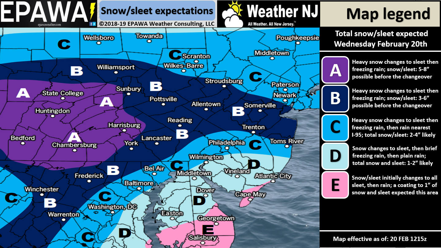
Click here to view full resolution snow/sleet map!
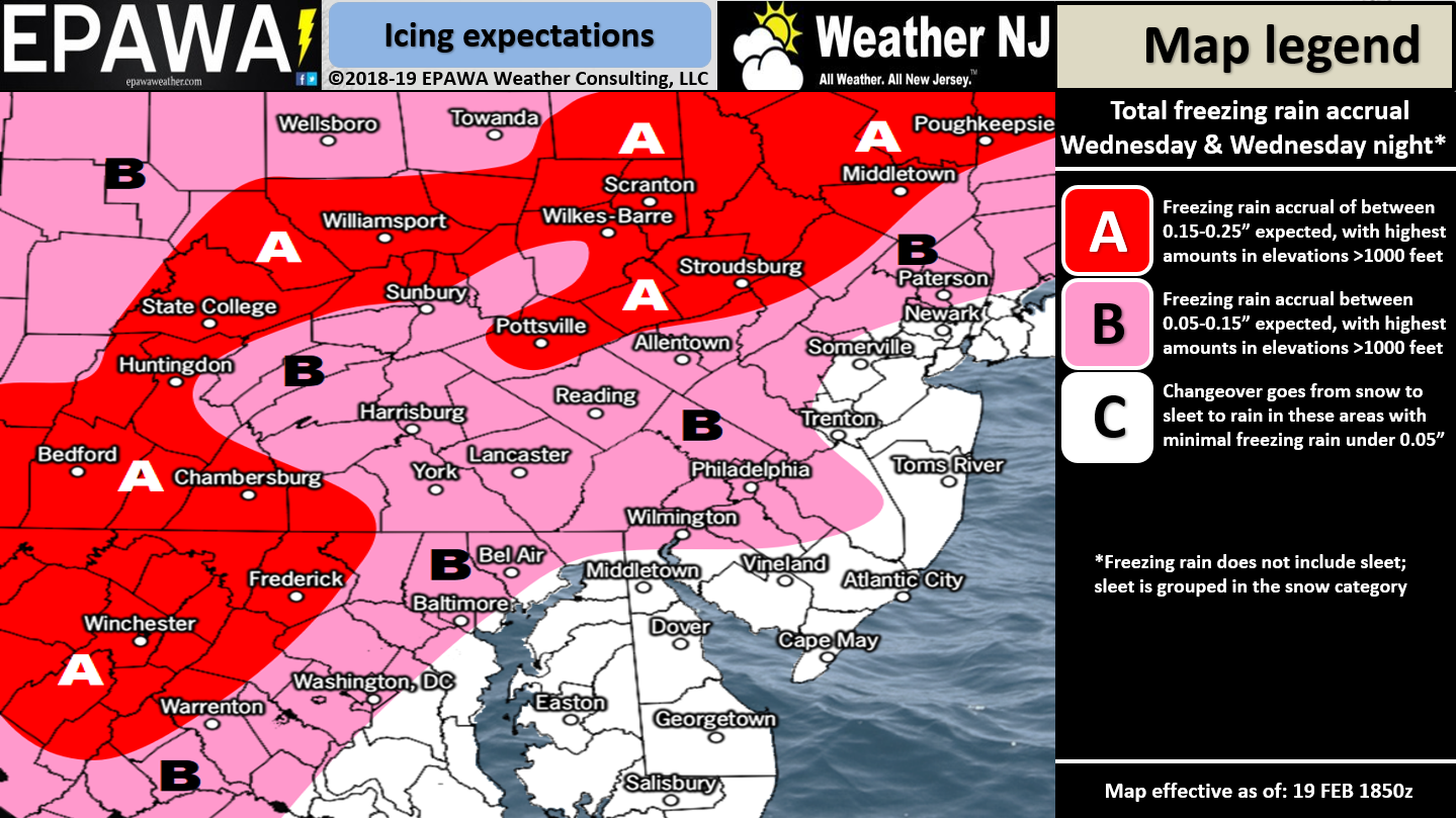
Click here to view full resolution freezing rain map!
Discussion: The upper-levels remain unfavorable for a major winter storm that starts and ends as snow. Instead we have above-average 500mb geo heights over the E US in a SouthWest Flow Event (SWFE) pattern with a strong 250mb jet streak. The high to the N of this system will be key in holding the cold air in the lower levels. This is the high that helped us drop so cold last night. This will allow the system to start with a wintry snow thump for most of NJ before changing over to ice and/or snow. The frontogenic forcing should be enhanced by the jet streak and produce redonkulous rates of wintry precipitation. Once the high slides out over the ocean however it will drive above-freezing SE flow in off the ocean and change NJ from snow to ice to rain from S to N.
I expect snow to start in SWNJ first tomorrow morning (between 7-9am). Snow should then spread through the rest of NJ by 2pm in the afternoon. I then expect the snow/ice line to start in extreme SNJ and advance from S to N between about 2pm and 7pm. Lastly I expect the ice/rain line to start in extreme SNJ and also advance from S to N between about 4pm and midnight. Extreme NNJ might never go to rain and just finish as ice. CNJ is favored for the heaviest thumping of snow before the changeover.
Ice should either be in the form of sleet and/or freezing rain depending on how deep or shallow the Warm Air Advection (WAA) layer is (between 850mb and 925mb). I expect SNJ and most of CNJ to make the change first from snow to rain. Northern/interior CNJ and most of NNJ should feature a prolonged period of icing between the snow and rain. This is all a complex process as there are many layers and moving parts involved. Once the ground warms above 32F then the freezing rain threat is over. Again this should happen quicker for SNJ, slower for CNJ and possibly not at all for NNJ especially elevations. Precipitation should wrap up between midnight Wednesday night and 2am Thursday morning.
In English: Tomorrow’s wintry event is a snow to ice to rain situation. Snow could start as early as 7-9am in SWNJ. It might be late-morning/early-afternoon until it’s really ripping snow and/or sleet but once it starts it will thump! I can see a lot of early-dismissals happening tomorrow so try not to get caught in the craziness if you can avoid it. Not a major snow event but enough snow and ice to wreck the day of many. Accidents will be numerous. The entire lower-2/3 of NJ should eventually change to rain by evening hours. I-78 and points N (especially N of I-80) will likely stay cold enough to end as snow or ice not rain. The above maps represent how much snow/sleet we think will fall in the first part of the day followed by how much freezing rain (ice) should fall afterwards. Again, not the major snow event many were hoping for but enough to take seriously for traffic safety reasons. Power outages are likely with the ice and winds. We’re leaning towards a harder wintry thump on this one. Live-casting begins late tonight and will go through all of tomorrow. Download the new free Weather NJ mobile app on Apple and/or Android. It’s the easiest way to never miss Weather NJ content. Our premium services go even further above and beyond at the hyperlocal level. Have a great rest of your President’s Day and please be safe! JC
Jonathan Carr (JC) is the founder and sole operator of Weather NJ, New Jersey’s largest independent weather reporting agency. Since 2010, Jonathan has provided weather safety and forecasting services for New Jersey and immediate surrounding areas through the web, social media, and app spaces. Originally branded as Severe NJ Weather (before 2014), Weather NJ is proud to bring you accurate and responsible discussions ahead of high-stakes weather scenarios that impact the garden state. All Weather. All New Jersey.™


LOCAL FORECAST | INTERACTIVE RADAR | LATEST NJ WEATHER ALERTS | WEDDING FORECAST| PRIVACY POLICY
© Copyright 2024 Weather NJ LLC. All Rights Reserved.
Some information that can be found on our website is provided by a private weather station and is not an officially recognized station for weather reporting. Though we always strive to achieve accurate reporting for our own use, it is important that you do NOT depend on the data provided here for any purpose.
