

Feb 28: Watching Wed PM T-Storms

What happened Saturday should happen again Wednesday evening. Let’s break it down…
Disco: The latest soundings are indicating an even more dynamic setup than this past Saturday. The following sounding was taken between Philadelphia, PA and Allentown, PA. That would put it just on the W side of Oxford Valley area. It is indicating MLCAPE values of 1300 j/kg which indicates to me that frequent lightning is possible. Lower-level lapse rates of 7.7 C/km and Lifted Index (LI) of -5 to -7 further argue how destabilized the region could become. Bulk shear from the surface to 6km (about 500mb) of 68 knots (almost 80mph) tells me that damaging wind gusts are possible at the surface. Typically these damaging winds are straight-line however a tornado did touch down in PA on Saturday. Again, this is for extreme E PA but it will set the stage for NJ impacts:
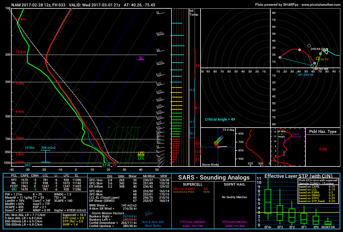
Once the storms cross over into New Jersey they will encounter more stable marine air the closer they get to the coast. Therefore the severe potential could dwindle for the immediate coastal plain. Frequent lightning, heavy downpours, small hail and strong winds can still make it through to the coast however as we saw the other night. W New Jersey therefore should see the strongest storms compared to E NJ.
The variance in the forecast is coming down to warm sector surface heating. Diurnal instability will be highly-dependent on this. If clouds and scattered showers are present tomorrow in the warm sector, then instability will be inhibited (the sun cannot reach ground to heat and destabilize) and therefore run-of-mill frontal precipitation with only possible embedded t-storms would likely occur. If the sun’s out then guns out for the more severe outcome. To play it safe, it’s always best to prepare for the more severe outcome but hope for the weaker one. The forecast does have that range though.
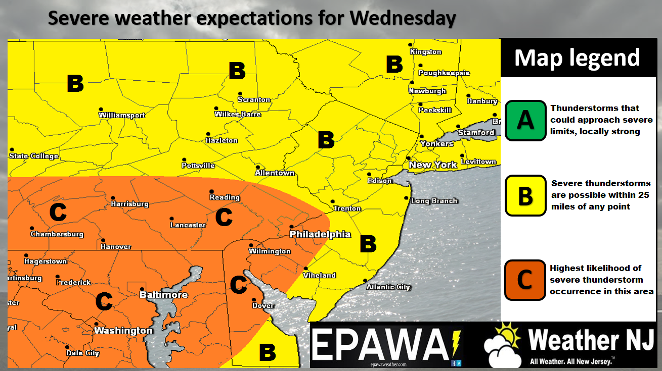
Click here for full-resolution storm impact map.
In English: We’ll stay mild and partly sunny today as the warm front pushes through. We should then stay mild overnight and tomorrow while we’re in the warm sector. Isolated-to-scattered rainfall is possible throughout this period but is not expected to be widespread. Winds today are out of the S which should warm areas away from the ocean well-into the 60s. A few interior CNJ/SNJ areas might flirt with 70. Immediate coastal areas should stay cooler due to Delaware Bay and Atlantic Ocean influence. Tomorrow the winds should pick up out of the SW which should warm most areas (even along the coast). I expect many areas to break 70 tomorrow (at least mid-60s) as SW winds gust ahead of the cold front. The greater threat then exists tomorrow night as the cold front pushes rain and thunderstorms through the region. Exact timing is still a bit difficult to nail down but in general, early-evening through late-evening from W to E. Storm intensity should be anything from run-of-mill rain with embedded storms to a more severe type of outbreak. It is rational to expect stronger storms in PA than NJ. You might see some interesting news come out of the Ohio Valley region earlier tomorrow. Just know that everything should be weaker by the time it gets to the coast. My advice is to prepare for the worst and hope for the best. I’ll have a beter handle on expected intensity tomorrow. And oh yeah, light snow is still possible on Friday. For now, have a great Tuesday and please be safe! JC
Jonathan Carr (JC) is the founder and sole operator of Weather NJ, New Jersey’s largest independent weather reporting agency. Since 2010, Jonathan has provided weather safety and forecasting services for New Jersey and immediate surrounding areas through the web, social media, and app spaces. Originally branded as Severe NJ Weather (before 2014), Weather NJ is proud to bring you accurate and responsible discussions ahead of high-stakes weather scenarios that impact the garden state. All Weather. All New Jersey.™


LOCAL FORECAST | INTERACTIVE RADAR | LATEST NJ WEATHER ALERTS | WEDDING FORECAST| PRIVACY POLICY
© Copyright 2024 Weather NJ LLC. All Rights Reserved.
Some information that can be found on our website is provided by a private weather station and is not an officially recognized station for weather reporting. Though we always strive to achieve accurate reporting for our own use, it is important that you do NOT depend on the data provided here for any purpose.
