

Feb 3: Coastal Snowfall Detected!
After the rain pushes through tonight, the cold front will stall just off our coast. A weak area of low pressure will then travel northward along the stationary front and throw in some moisture off the Atlantic Ocean into air just cold enough to produce snow at the mid-to-upper levels. The surface could be pesky temperature-wise which could affect final snowfall accumulations. It might be the case where accumulations are higher on natural surfaces and reduced on paved surfaces. For this reason I think plenty of snow will fall however final accumulations should be knocked down by the warmer surface temperature profile.

This baby snow event however has two things that could work in favor of seeing the higher end of the accumulation range. 1) It’s happening during overnight hours (no solar surface heating to fight it) and 2) Precipitation rates could overpower the surface with colder mid-level air. For this stated uncertainty, surface temperatures will have to be now-casted. Daytime temperatures tomorrow will still be pretty mild (for snow). This events magnitude will all depend on how quickly the surface cools to 32 or just below heading into overnight tomorrow night/early Friday AM hours.
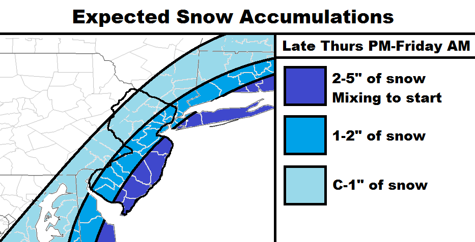
We’re looking at a very sharp cutoff to the W regarding snow vs. no snow. That cut-off could realistically range between Lancaster, PA and just E of Philly. I believe my snow map above expresses all of these ideas and concerns. Have a great night and be safe! JC
Jonathan Carr (JC) is the founder and sole operator of Weather NJ, New Jersey’s largest independent weather reporting agency. Since 2010, Jonathan has provided weather safety and forecasting services for New Jersey and immediate surrounding areas through the web, social media, and app spaces. Originally branded as Severe NJ Weather (before 2014), Weather NJ is proud to bring you accurate and responsible discussions ahead of high-stakes weather scenarios that impact the garden state. All Weather. All New Jersey.™


LOCAL FORECAST | INTERACTIVE RADAR | LATEST NJ WEATHER ALERTS | WEDDING FORECAST| PRIVACY POLICY
© Copyright 2024 Weather NJ LLC. All Rights Reserved.
Some information that can be found on our website is provided by a private weather station and is not an officially recognized station for weather reporting. Though we always strive to achieve accurate reporting for our own use, it is important that you do NOT depend on the data provided here for any purpose.
