

Feb 3: Ice Storm Detected for NNJ
Discussion: While the overall Polar and Pacific weather patterns, including key teleconnections and oscillations, remain generally unfavorable for winter weather in New Jersey, we do have a few thread the needle events to watch this week. We’re basically going to have a frontal boundary fluctuating N and S with the onslaught of disturbances and low pressure systems riding this boundary from W to E.
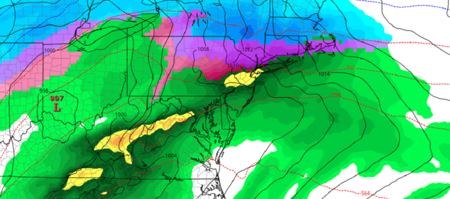
Today through Wednesday mostly all of NJ is above freezing and should be enjoying the mild weather. Wednesday night into Thursday morning the frontal boundary dips to about the I-80 latitude (possibly down to I-78) across NNJ/CNJ. Areas to the S of this will remain too warm for wintry precipitation (just rain). Areas N of I-78 are looking at a period where colder overnight temperatures chill out the surface below freezing and then rise above-freezing by late-morning Thursday. During that period (mainly late-Wednesday night into Thursday morning) precipitation will start out as snow in the mid-levels, change to rain in the low-mid levels, and then re-freeze into either sleet or freezing rain by the time it hits the surface.
With that said, NNJ (N of I-78 and NW of I-287) is looking at a potential ice storm for the Thursday AM rush hour. I-78 would likely be the southern extent of it. I-80 would likely be a “u know what” show. By afternoon temperatures at all levels rise back above freezing mitigating the ice threat. Precipitation then lingers through the rest of Thursday and wraps up by Friday afternoon/evening with a final trailing low. There could be some changeover (back to ice/snow) on Friday mainly for parts of NNJ but nothing serious looking as of now. Again if you’re S of I-78 and/or SE of I-287 your probably looking at milder temperatures and all rain this week. I-78 and N/I-287 and NW need to pay attention especially Thursday AM. We’ll have ice impact maps out in the near future.
Next we have the long-range February 8 winter storm signal that we’ve been referring to, which is now looking more like a Feb 9 event. Regardless, temperatures will be crashing Friday night behind the departing low. This should set up a colder Friday night, Saturday and Sunday morning ahead of the approaching Sunday system. A weak low is expected to ejext off the OBX area and pass over the 40N/70W benchmark. As of right now NNJ, CNJ and possibly SWNJ look the most favored for snowfall. SNJ might be cold enough aloft but would likely deal with marginal surface temperatures. Areas like Atlantic City down through Cape May would be the least likely to see wintry precipitation especially during the onshore flow component (when winds are off the ocean). But even SENJ temperatures might crash and end with trace accumulations once winds become more northerly than easterly. But as long as winds are off the ~40F ocean then surface temps will remain above freezing and likely in the 40s. Interior SNJ (especially SWNJ) would have a better chance than SENJ for snow accumulations. I’ll continue to watch this evolve. Snow maps for this Sunday system wouldn’t come until probably Thursday. Responsible discussion only until so.
In English: Today feels great. Tomorrow should remain milder but clouds likely build in. Late Tuesday night through Friday should be the unsettled period with mild conditions persisting and mostly light/moderate periods of on-and-off rain. NNJ however should begin anticipating an icing event late-Wednesday into Thursday morning. Whether I-78 or I-80 is the southern extent of it is still yet TBD (probably I-80) but I-287 will likely cap the SE extent into NENJ. We then warm back up by Thursday PM into Friday and cool back down Friday night into the weekend as precip pulls away. Parts of NNJ (likely NWNJ) could see a snowy end as temps fall on Friday but with little-to-no accumulations likely. Accumulating snowfall is then possible from a more robust winter storm between late-Saturday night and early-Monday morning (mostly during Sunday hours). It looks potentially plowable all the way down to the turnpike possibly even down to I-195 and northern SNJ/SWNJ. SENJ and extreme SNJ are looking too warm at this point for anything more than ending trace accumulations once temps crash. I’ll be watching closely each day this week for any trends. Have a great rest of your Monday and please be safe! JC
Download the new free Weather NJ mobile app on Apple and/or Android. It’s the easiest way to never miss Weather NJ content. Our premium services go even further above and beyond at the hyper-local level. Looking for industrial-caliber long-range forecasting data that I personally recommend? Check out WeatherTrends360! Visit the Weather NJ Kaboom Shop for hoodies, tees and infant onesies.
Jonathan Carr (JC) is the founder and sole operator of Weather NJ, New Jersey’s largest independent weather reporting agency. Since 2010, Jonathan has provided weather safety and forecasting services for New Jersey and immediate surrounding areas through the web, social media, and app spaces. Originally branded as Severe NJ Weather (before 2014), Weather NJ is proud to bring you accurate and responsible discussions ahead of high-stakes weather scenarios that impact the garden state. All Weather. All New Jersey.™


LOCAL FORECAST | INTERACTIVE RADAR | LATEST NJ WEATHER ALERTS | WEDDING FORECAST| PRIVACY POLICY
© Copyright 2024 Weather NJ LLC. All Rights Reserved.
Some information that can be found on our website is provided by a private weather station and is not an officially recognized station for weather reporting. Though we always strive to achieve accurate reporting for our own use, it is important that you do NOT depend on the data provided here for any purpose.
