

Feb 5: Thursday Snow Video
Models continue to suggest snowfall for Wednesday night into Thursday morning. Here are my current thoughts…
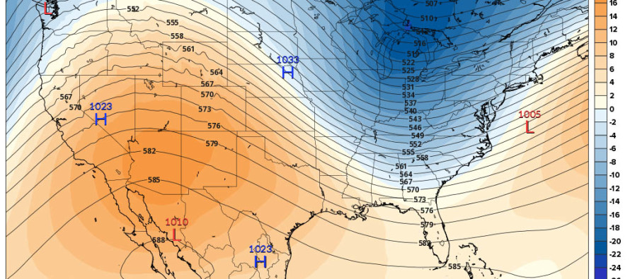
Text version of video: The upper levels over the US are temporarily aligning in a favorable flow for winter storm development. However, we are lacking dynamics that would normally slow a system like this down into something larger. Therefore, it’s a quick and progressive system that might just track perfectly for a plowable wintry event this Wednesday night into Thursday morning. The latest ensemble packages of the GFS and Euro support this idea. To be clear, a major snow storm is not modeled. A plowable snow storm however has gained support over the last 24 hours.
Temperatures appear cold enough to support snow from 500-850mb. Temperatures are marginal however from 850mb to the surface for those SE of the I-95 corridor. Therefore, those along and NW of the I-95 corridor would see surface conditions more favorable for stickage than those SE. Precipitation rates could eventually over-power the warmer surface for those SE of I-95. The jury is still out on that. Let’s see how this continues to evolve.
In English: A light-to-moderate snow event is possible for New Jersey Wednesday night into Thursday morning. I’ll have more details each day as we closer approach. Be safe! JC
Jonathan Carr (JC) is the founder and sole operator of Weather NJ, New Jersey’s largest independent weather reporting agency. Since 2010, Jonathan has provided weather safety and forecasting services for New Jersey and immediate surrounding areas through the web, social media, and app spaces. Originally branded as Severe NJ Weather (before 2014), Weather NJ is proud to bring you accurate and responsible discussions ahead of high-stakes weather scenarios that impact the garden state. All Weather. All New Jersey.™


LOCAL FORECAST | INTERACTIVE RADAR | LATEST NJ WEATHER ALERTS | WEDDING FORECAST| PRIVACY POLICY
© Copyright 2024 Weather NJ LLC. All Rights Reserved.
Some information that can be found on our website is provided by a private weather station and is not an officially recognized station for weather reporting. Though we always strive to achieve accurate reporting for our own use, it is important that you do NOT depend on the data provided here for any purpose.
