

Feb 6: Winter Storm Update
![]()
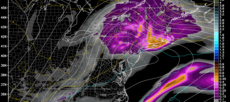
The northerly trend in model guidance appears to have halted now that better data sampling has been fed into their algorithms. Precipitation should begin falling Sunday evening and taper off Tuesday morning. We’re dealing with another snow/rain line moving northward during the first half of the system and returning southward for the second half. With that being said, the snow/rain line could make it as far north as NNJ on Monday during the closest proximity to the low pressure center. As the low pulls away, temperatures will crash and all precipitation will change to snow after a possible period of mixing. The amounts given above take into consideration all precipitation types when all is said and done on Tuesday.
As we saw with the last system, there is the potential for a period of icing especially for CNJ and lower parts of NNJ. This can include sleet and/or freezing rain during temperature transitions. While .1 inch of ice is a reasonable expectation, .25 inch of ice is not out of the question. This threat would be greatest in the Monday evening-Tuesday morning time-frame. It’s also a possibility at the start of the storm late Sunday night into Monday morning. Monday for the most part will be the warmest period of the storm with rain pushing as far north as NNJ.
In English: Mostly snow for NNJ, a sloppy mix for CNJ and mostly rain for SNJ. All areas could end as light snow as the system pulls away on Tuesday morning. Be safe! JC
Model image used with permission from WeatherBell Analytics.

Jonathan Carr (JC) is the founder and sole operator of Weather NJ, New Jersey’s largest independent weather reporting agency. Since 2010, Jonathan has provided weather safety and forecasting services for New Jersey and immediate surrounding areas through the web, social media, and app spaces. Originally branded as Severe NJ Weather (before 2014), Weather NJ is proud to bring you accurate and responsible discussions ahead of high-stakes weather scenarios that impact the garden state. All Weather. All New Jersey.™


LOCAL FORECAST | INTERACTIVE RADAR | LATEST NJ WEATHER ALERTS | WEDDING FORECAST| PRIVACY POLICY
© Copyright 2024 Weather NJ LLC. All Rights Reserved.
Some information that can be found on our website is provided by a private weather station and is not an officially recognized station for weather reporting. Though we always strive to achieve accurate reporting for our own use, it is important that you do NOT depend on the data provided here for any purpose.
