

Feb 8: Snow Storm Approaching!
Here’s are my thoughts heading into this redonkulously difficult forecast:
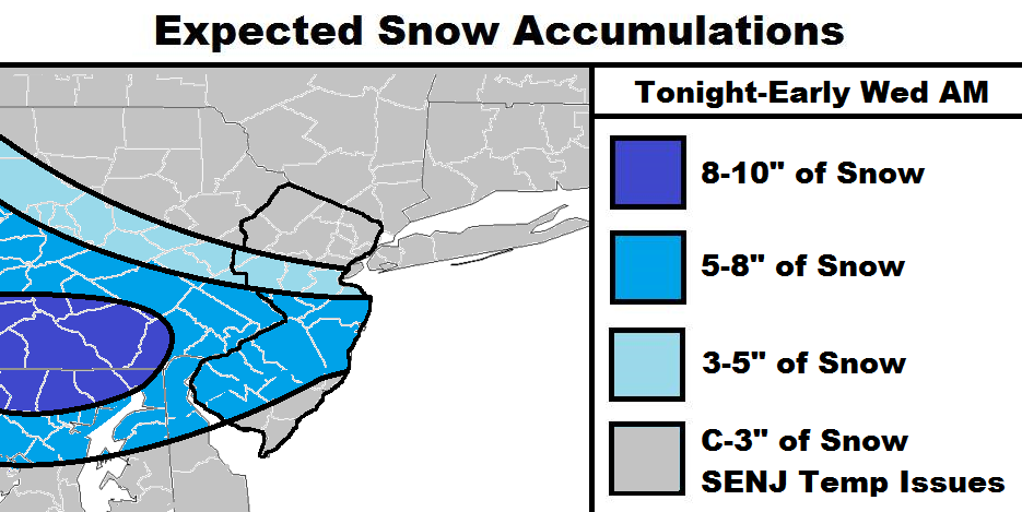
Discussion: Low pressure is about to transfer from the Great Lakes to the Mid-Atlantic coast near the VA/NC border. It will then move NE into the Atlantic Ocean and bring upon the inverted trough across our region. As the map indicates, I believe the inverted trough is going to target the general CNJ/SNJ area. While SENJ could see the same snowfall rates as everyone else in the 5-8″ blue zone, I’m skeptical of the surface temperature profile presenting stickage issues. I’ll have an observation article out this evening around 9:30PM. This will allow me to compare critical short-range model data to real observations and make any needed adjustments to my thinking.
I CANNOT EMPHASIZE the uncertainty enough in this forecast. You could very well find me lowering totals statewide should the surface end up too far above-freezing. Inverted troughs are incredibly volatile with great variance in the outcome. It was this mechanism in central PA that caused the Great Bust of January 2015. That along with a late phase. Regardless, expect surprises.

In English: Light snow is already breaking out in several places. Snowfall should be on and off overnight and into tomorrow (moreso for SWNJ than points NE). It should then snow lightly on and off for most of the day on Tuesday and wrap up before sunrise on Wednesday. The map is straight-forward in what to expect between that period of time (worst case scenario). Again, don’t be disappointed if you find me lowering totals. Yes, this is indeed a long period of snowfall, not a quick thumping. I’ll see you at 9:30PM for a now-casting/observation update. Have a great evening and be safe! JC
Jonathan Carr (JC) is the founder and sole operator of Weather NJ, New Jersey’s largest independent weather reporting agency. Since 2010, Jonathan has provided weather safety and forecasting services for New Jersey and immediate surrounding areas through the web, social media, and app spaces. Originally branded as Severe NJ Weather (before 2014), Weather NJ is proud to bring you accurate and responsible discussions ahead of high-stakes weather scenarios that impact the garden state. All Weather. All New Jersey.™


LOCAL FORECAST | INTERACTIVE RADAR | LATEST NJ WEATHER ALERTS | WEDDING FORECAST| PRIVACY POLICY
© Copyright 2024 Weather NJ LLC. All Rights Reserved.
Some information that can be found on our website is provided by a private weather station and is not an officially recognized station for weather reporting. Though we always strive to achieve accurate reporting for our own use, it is important that you do NOT depend on the data provided here for any purpose.
