

Feb 9: Tracking Two Wintry Systems

Two wintry systems are expected in the first half of this week. To be outright neither system is a big snow storm however they should have high-impact on travel. At the end of the day we’re here for safety…
First System (late-Sunday night through Monday Afternoon):
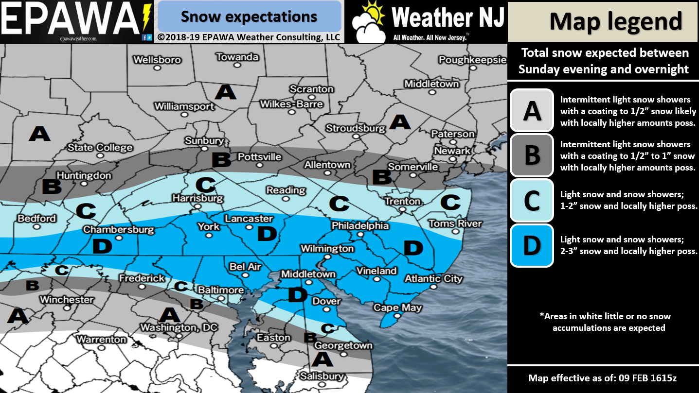
Click here to view full resolution map!
Discussion: The first system arrives late Sunday night in the form of a leading slider for the second system. I’m finding that the end time on Monday is getting later and later as model guidance evolves. In fact I wouldn’t be surprised to see little if any break in precipitation Monday before the second system arrives. Regardless, this first system is targeting SNJ with a jackpot of 2-3 inches with locally higher amounts possible. We know it’s a cold weekend and therefore stickage should be instant. This should produce travel hazards for NJ along and S of I-195 in general. This system has trended colder and snowier over the last 24 hours. We still have tonight and tomorrow’s data to watch for any continued trends. If anyone is going to briefly go over to mixed precipitation or rain it would be Cape May County and S parts of Cumberland/Atlantic. Otherwise we know how these SNJ events can go (think last week).
Second System (Early Tuesday morning through early Wednesday morning):
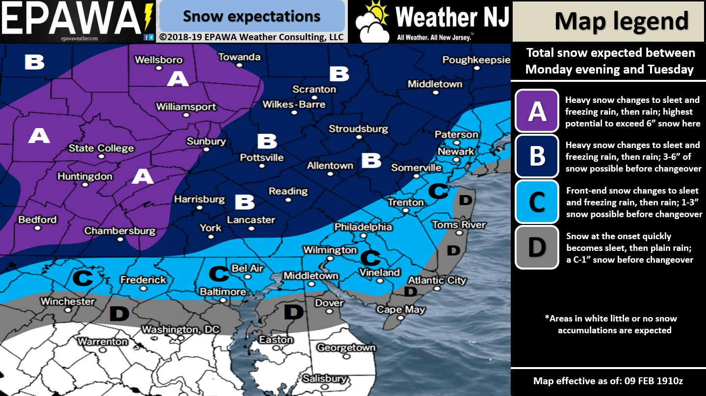
Click here to view full resolution map!
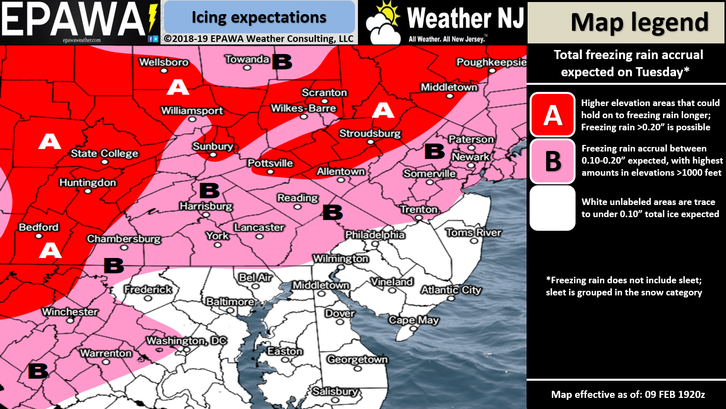
Click here to view full resolution map!
Discussion: This second system should start early Tuesday morning for NJ. Again, the timing gap has closed on recent model guidance to suggest near-continuous precipitation from the first system to this second system. If that happens then a snowier outcome would likely result from the first system. It would then mean snow from late-Sunday night through early-Tuesday morning. But regardless there will be a changeover to rain at some point on Tuesday. We’ll be under above-average upper-level height anomalies and strong SW flow in the mid-levels. This should change most of NJ along and SE of I-95/NJTP over to rain fairly quickly between about 2am and 6am. Areas NW of I-95/NJTP should hang onto cold at the surface a little longer…even if the mid-levels rise above freezing. This would mean more sleet and/or freezing rain before changing over to rain. Here lies the Tuesday AM travel safety hazard. Extreme NWNJ has the best chance of anyone to see the most wintry outcome from this second event. Precipitation should end for all areas by Wednesday morning if not by Tuesday night.
In English: Snow is likely from late-Sunday night through Monday morning with SNJ most-targeted. A snow to ice to rain event is then likely from Monday night through most of Tuesday possibly into early Wednesday AM. There’s a small chance the snow continues Monday into Monday night but I’m just keeping an eye on that trend for now. The above maps represent our expected wintry accumulations for each period of interest. The primary wintry safety hazards exist for at least Monday and Tuesday AM travel. Again I’m watching if Monday PM travel will also be affected. We’ll make any adjustments tomorrow if necessary after reviewing fresh model data and live observations upstream. Download the new free Weather NJ mobile app on Apple and/or Android. It’s the easiest way to never miss Weather NJ content. Have a great rest of your Saturday and please be safe! JC
Jonathan Carr (JC) is the founder and sole operator of Weather NJ, New Jersey’s largest independent weather reporting agency. Since 2010, Jonathan has provided weather safety and forecasting services for New Jersey and immediate surrounding areas through the web, social media, and app spaces. Originally branded as Severe NJ Weather (before 2014), Weather NJ is proud to bring you accurate and responsible discussions ahead of high-stakes weather scenarios that impact the garden state. All Weather. All New Jersey.™


LOCAL FORECAST | INTERACTIVE RADAR | LATEST NJ WEATHER ALERTS | WEDDING FORECAST| PRIVACY POLICY
© Copyright 2024 Weather NJ LLC. All Rights Reserved.
Some information that can be found on our website is provided by a private weather station and is not an officially recognized station for weather reporting. Though we always strive to achieve accurate reporting for our own use, it is important that you do NOT depend on the data provided here for any purpose.
