

Jan 10: Light Snow Event Expected
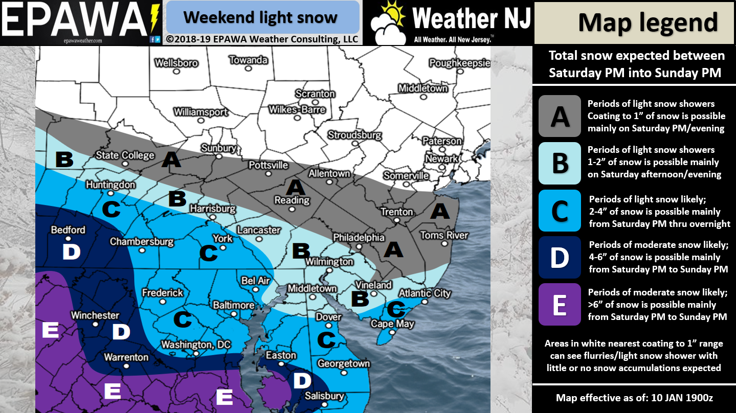

Discussion: Low pressure will track across the SE US and eject into the Atlantic Ocean over OBX. From there it is not expected to turn up the coast and produce a major snow storm. Instead it will likely remain on a flat trajectory out to sea leaving many N areas snowless. It’s really only SNJ at this point who can still see a plowable event and that might be only extreme SNJ. CNJ and especially NNJ are likely looking at little-to-no accumulations. We can probably narrow the timing down now to between midnight Saturday night and early-evening Sunday. Most snowfall should be light with only a small chance of some moderate bands setting up for extreme SNJ.
There are a few wildcard scenarios here. First, the confluence could be so strong that it creates a lot of virga in NNJ/SNJ. Virga is snow that evaporates before hitting the ground despite showing up as blue snow on radar. In this case SNJ would see the lower end of expectations. The opposite spectrum wildcard is that the coastal consolidates and produces a strong snowy finish between late-morning and early-evening on Sunday. Both of these wildcards would basically push the needle a few inches either way of our above snow map. Otherwise, this is not a big deal but it doesn’t take much to reduce visibility and create travel hazards.
The long-range pattern looks healthy in terms of wintry cold and action. This Polar Vortex-sourced cold is not going to leave soon. It will likely keep us in the wintry pattern to close January and at least open the first half of February. So while this weekend’s system is somewhat of a disappointment for those wanting a big snow storm, it’s the start of a favorable snowy pattern. It sure beats 2 inches of rain this time of year IMO.
In English: For a full-resolution snow map please click here. This is not a big deal folks. It’s a light snow event with SNJ favored to see up to a few inches. Light snowfall for affected areas should begin before midnight on Saturday and taper off by Sunday night. The above map represents our evidence-based reasonable expectations. Just a note that the white area does not represent snow. The white area, as defined in the legend, represents no form of precipitation. With this approaching system it’s not a bad time to download the new free Weather NJ mobile app on Apple and/or Android. Have a great night and please be safe! JC
Jonathan Carr (JC) is the founder and sole operator of Weather NJ, New Jersey’s largest independent weather reporting agency. Since 2010, Jonathan has provided weather safety and forecasting services for New Jersey and immediate surrounding areas through the web, social media, and app spaces. Originally branded as Severe NJ Weather (before 2014), Weather NJ is proud to bring you accurate and responsible discussions ahead of high-stakes weather scenarios that impact the garden state. All Weather. All New Jersey.™


LOCAL FORECAST | INTERACTIVE RADAR | LATEST NJ WEATHER ALERTS | WEDDING FORECAST| PRIVACY POLICY
© Copyright 2024 Weather NJ LLC. All Rights Reserved.
Some information that can be found on our website is provided by a private weather station and is not an officially recognized station for weather reporting. Though we always strive to achieve accurate reporting for our own use, it is important that you do NOT depend on the data provided here for any purpose.
