

Jan 17: Weekend Winter Storm Update

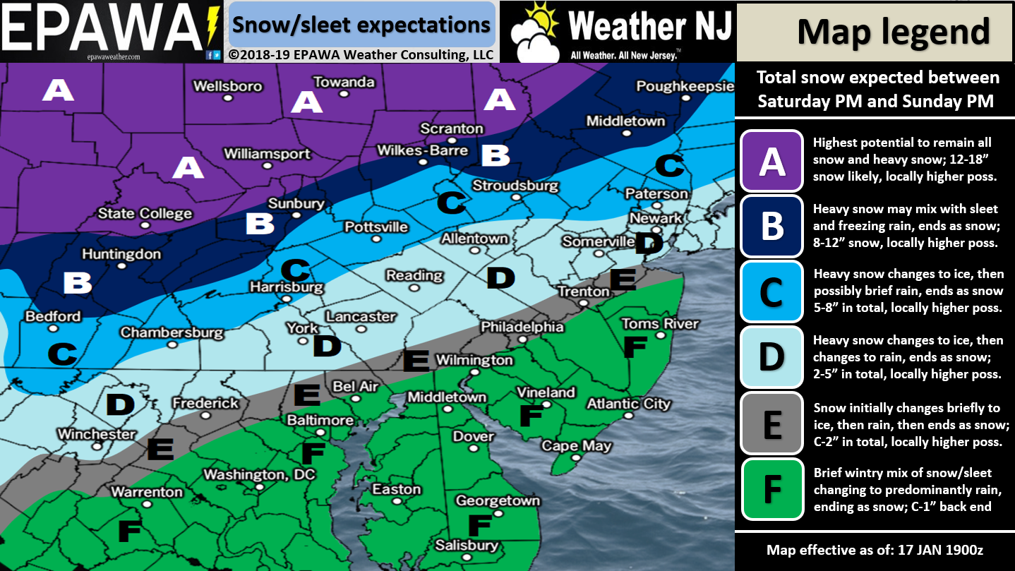
For full-resolution snow map please click here!
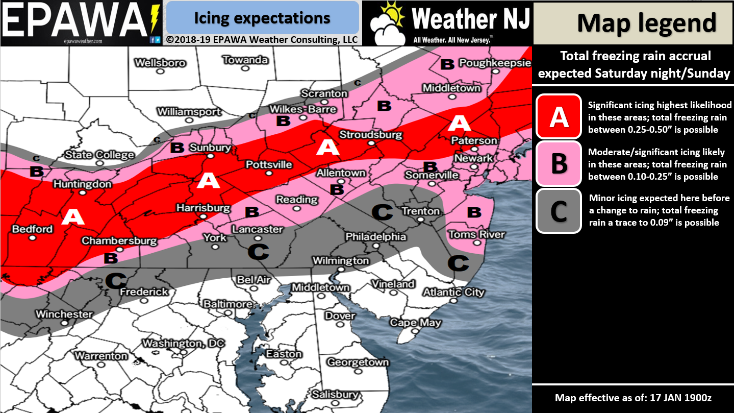
For full-resolution ice map please click here!
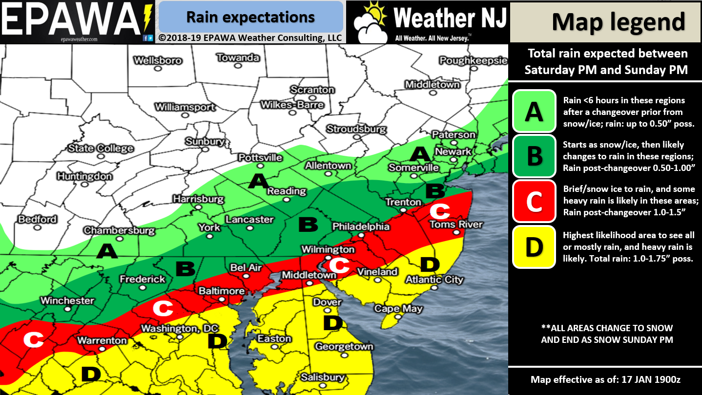
For full-resolution rain map please click here!
Discussion: The above winter storm impact maps are fairly self-explanatory. As far as pure snow goes only NJ areas N of I-78 are favored for significant to major snowfall. Extreme NNJ has the best chance to reach into the major snowfall range. Ice is probably the most dangerous aspect of this storm and this threat includes NNJ, CNJ and even parts of SNJ. The ice map above represents any sleet and/or freezing rain that could fall (we’re expecting mostly freezing rain over sleet but both are possible). There is also the chance for a flash freeze Sunday night once precipitation ends. The entire State of NJ will dip well-below freezing overnight into Monday. Whatever is not evaporated by trailing NW winds will DEFINITELY freeze. This brings an ice threat back to even the warmest areas of SENJ that are expecting to see mostly rain during the period of precipitation. As far as rainfall goes SENJ is favored to see the most amount of rain after quickly changing over from any initial front-end thump of snow.
There exists a small chance of coastal flooding Sunday morning when winds shift to the SE direction. This is when SE winds over the ocean will team up with the near full moon. This could result in a very minor surge stacked on top of the already higher astronomical tides associated with the full moon. I don’t think we reach moderate stage flooding but do think we have a chance for minor stage flooding.
As far as timing goes I expect precipitation to approach from the W and begin for WNJ by late-Saturday afternoon/early-Saturday evening. I then expect precipitation to taper off by Sunday afternoon. Expect a snow/ice/rain line to begin in SNJ/SENJ and advance northward during the precipitation. Right now the best data indicates this snow/ice/rain line making it as far N as I-80. My gut suspicion says it might not make it that far bringing more of CNJ into the colder snowier/icier scenario but I have no data to support it. Just a gut feel. For now the above maps represent our (Weather NJ + EPAWA Consulting) best evidence-based reasonable guess of outcomes.
In English: For a full-resolution snow map please click here. Another wintry system is expected to impact NJ this weekend between Saturday afternoon/evening and Sunday afternoon. NWNJ is favored for the most snow/ice. SENJ is favored for the most rainfall. Areas between should see a battleground of snow vs ice vs rain. Once all precipitation finishes Sunday afternoon temperatures will then drop below-freezing for all of NJ—freezing any wet roads that haven’t been evaporated yet. I know you all focus mostly on snow but ice is the most significant danger from this system IMO both during for NNJ/CNJ and afterwards for all of NJ. Minor coastal flooding is possible Sunday morning. There will be daily articles from now until Saturday featuring updated winter storm impact maps as needed. Thank you all for your patience and understanding in predicting a very volatile high safety impact winter storm system. Find out why over 12,500 people have now downloaded the new free Weather NJ mobile app on Apple and/or Android. It’s the easiest way to never miss Weather NJ content. Have a great rest of your evening and please be safe! JC
Jonathan Carr (JC) is the founder and sole operator of Weather NJ, New Jersey’s largest independent weather reporting agency. Since 2010, Jonathan has provided weather safety and forecasting services for New Jersey and immediate surrounding areas through the web, social media, and app spaces. Originally branded as Severe NJ Weather (before 2014), Weather NJ is proud to bring you accurate and responsible discussions ahead of high-stakes weather scenarios that impact the garden state. All Weather. All New Jersey.™


LOCAL FORECAST | INTERACTIVE RADAR | LATEST NJ WEATHER ALERTS | WEDDING FORECAST| PRIVACY POLICY
© Copyright 2024 Weather NJ LLC. All Rights Reserved.
Some information that can be found on our website is provided by a private weather station and is not an officially recognized station for weather reporting. Though we always strive to achieve accurate reporting for our own use, it is important that you do NOT depend on the data provided here for any purpose.
