

Jan 20: Strong Coastal Storm Detected!
Models continue to suggest a strong coastal storm this Sunday night through Tuesday. While it’s possible for points NW to mix with wintry precipitation, wind and coastal disruption are looking like the main story. Let’s break it down…
Disco: At the upper levels, not much has changed over the past 48 hours of guidance. We still have a 250mb negatively-tiled trough with impressive frontal jet streak over the east coast during the main period of interest. We still have a 500mb shortwave moving across the S US and closing off near Texas before turning up the east coast. What’s still uncertain however is the exact track of the upper low, which will have tremendous influence on the surface low’s track. If these tracks are more NW then the system is all rain for everyone. If the system hangs out a little to the SE (further off the coast) then points NW (including PA/NWNJ/NY elevations) could see wintry precipitation mix in with the heavy rain. Also, there are favorable upper-level dynamics that could produce an overall colder environment but we’re simply not there yet. Tomorrow we should have a much more confident stance on that.
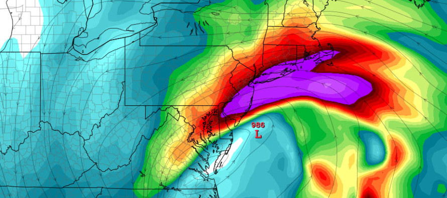
The bigger story with this system IMO will be wind (for all areas) and coastal conditions. I’m seeing a lower-level (850mb) onshore jet of 60-80kts (70-90mph). The purple area of the above cover image represents such. That’s at about 5,000 feet up. Closer to the surface, I’m seeing 40-50kt (45-60mph) onshore winds. With all impressive dynamics involved, the 850mb winds could easily be brought to the surface which would allow for impressive gusts region-wide. The coast would take these winds to the face and all the coastal flooding that comes with them. Storm surge guidance indicates a possible storm surge of 3-5 feet along the Jersey coast with tidal levels about 6 feet above MLLW. The moon will be approaching the new phase as well. With that said, my confidence is increasing in moderate coastal flooding and region-wide high winds with severe/damaging gusts possible.
Expected rainfall is still modeled region-wide at 1-3 inches total. It would be common for isolated areas under the heaviest convective banding to see 3+ inches but that’s an 11th hour/now-casting call. 1-3 region-wide is the best way to play it right now.
In English: Confidence is increasing in a large-scale coastal/rain storm starting as early as Sunday night and wrapping up by Tuesday night.
Widespread rainfall could be heavy at times and winds could be very gusty (possibly damaging). Periods of wintry precipitation could mix into the rain for NWNJ elevations but the jury is still out on this. There is still much uncertainty as to how cold the NW side of the storm could get. For most of the state, all rain is still the most rational expectation. I’ll continue to watch if this system trends any colder (meaning snow comes further SE) but as of now, it’s only the NWNJ elevations who have a small chance.
Coastal concerns are increasing given the expected heavy rainfall (1-3 inches+) and wind-driven storm surge (3-5 feet) contributing to 2-3 high tides of ~6 feet above MLLW. The Raritan Bay and Long Island Sound could see levels a few feet higher than that. Right now, I’d say the entire Jersey coast is looking at minor-to-moderate coastal flooding with solid beach erosion. Back bays, especially the Delawayre, Raritan/Lower Bays and W Long Island Sound would likely see the higher storm surge amounts given the funnel effect of wind over water. Some might call this a nor’easter (to each is own) however most of the higher storm winds should be out of the SE and E. SE and E winds are actually worse for Jersey inlets leading into back bays since they will be parallel to the onshore flow (hat tip to Chris Huch for that knowledge). The system does still appear to take a slight retrograde in track which could further argue this as a nor’easter. I’m just going to go with a strong coastal storm for now. NJ has seen this before. It won’t be Sandy-bad but it could easily fall in the upper-range of a moderate coastal event.
My Pocket Meteorologist text alerts will begin soon for this event with detailed hyper-local impacts to your specific area. Have a great day and please be safe! JC
Jonathan Carr (JC) is the founder and sole operator of Weather NJ, New Jersey’s largest independent weather reporting agency. Since 2010, Jonathan has provided weather safety and forecasting services for New Jersey and immediate surrounding areas through the web, social media, and app spaces. Originally branded as Severe NJ Weather (before 2014), Weather NJ is proud to bring you accurate and responsible discussions ahead of high-stakes weather scenarios that impact the garden state. All Weather. All New Jersey.™


LOCAL FORECAST | INTERACTIVE RADAR | LATEST NJ WEATHER ALERTS | WEDDING FORECAST| PRIVACY POLICY
© Copyright 2024 Weather NJ LLC. All Rights Reserved.
Some information that can be found on our website is provided by a private weather station and is not an officially recognized station for weather reporting. Though we always strive to achieve accurate reporting for our own use, it is important that you do NOT depend on the data provided here for any purpose.
