

Jan 22: Weekend Winter Storm Update
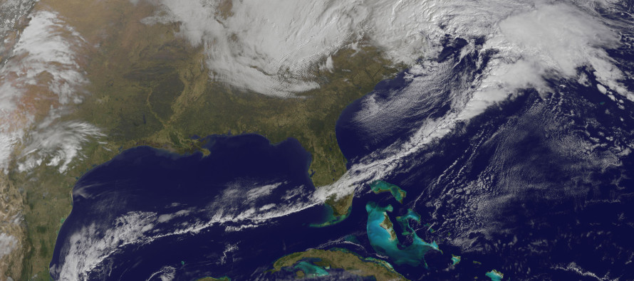
A deepening low pressure disturbance will take a classic “benchmark 40N/70W” track between tomorrow and Saturday. This will bring up a a decent amount of moisture from the Gulf of Mexico as well as throw in a lot of moisture from the Atlantic Ocean before pulling away. It’s best to break the entire event down into three phases.
Phase 1 (Tomorrow night-Saturday Morning): When the low pressure is way to the S and SW of NJ tomorrow evening, it will be throwing gulf moisture northward into cold air. Overnight temperatures tomorrow night are expected to drop below freezing for most of the state. This could allow for snow to start falling since there won’t be a warm flow off the ocean yet. By sunrise Saturday morning, the low should be more to our S/SE and beginning it’s deepening process. Most guidance puts this time-frame’s low intensity at ~1000mb which is pretty strong for just coming off Delmarva/OBX. At that point phase 1 ends and snow begins changing to rain.
Phase 2 (Saturday morning-afternoon): This will be a warm and rainy phase for the I-95 corridor and possibly even some points NW. Cyclonic (counter-clockwise) E/SE flow off the ocean should keep the 925-850mb levels of the atmosphere above freezing—melting any snow being produced in the 850-700mb levels. Look for this phase to conclude when easterly winds switch to more of a northerly direction. This will geometrically coordinate with the position of the cyclonic low arriving to our east. That should eventually return the warmer lower-mid levels of the atmosphere to below freezing temperatures and allow precipitation to change back over to snow. This phase will feature the greatest impact to coastal regions including high winds, beach erosion, and minor flooding.
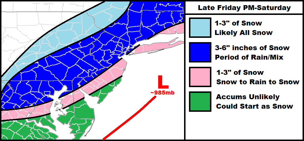
Phase 3 (Saturday afternoon-evening): By sundown on Saturday, N/NE winds should be changing precipitation from rain to snow from NW to SE (will be tracking during now-casting). The sun will also be setting resulting in even more loss of heat. With a low of that intensity departing our region, expect these northerly winds to howl pretty good into Saturday night. Once the precipitation shield ends from west to east that will be it for accumulating snow chances. How much snow falls in in both Phase 1 and 3 are represent the rationale behind my snow map above.
Notes: This is a fairly fast moving system due to inadequate high-latitude Atlantic blocking. There’s no 50/50 low to slow it down either. Also we don’t have solid high pressure to the north to feed in cold air at the lower levels. There’s actually a low to our north that will be pulling more stale air in from the W. Enough stale cold air, however, should be available for significant accumulations in the jackpot zone but not the true Arctic air needed for an intense thermal gradient (thundersnow + freak mesoscale snow bands) resulting in heavy accumulations. With that being said, this system’s snowy over-performance will rely on itself to expand its own column and make its own cold air—not relying on the cold surrounding it’s environment. 9 times out of 10 that doesn’t work out but if this low bombs below 980mb, you’ll at least see some degree of adiabatic and/or dynamic cooling. With that said, this is why I’m only feeling more of a significant event rather than a major event.
In English: Expect a possible snowy start, middle period of rain, and ending period of snow starting tomorrow evening and clearing out as late as Saturday night. Moderate wind gusts and heavy rainfall are expected during the middle rainy period of this storm (Saturday morning-afternoon). I’ll have a final call/map posted tomorrow afternoon. Be safe! JC

Jonathan Carr (JC) is the founder and sole operator of Weather NJ, New Jersey’s largest independent weather reporting agency. Since 2010, Jonathan has provided weather safety and forecasting services for New Jersey and immediate surrounding areas through the web, social media, and app spaces. Originally branded as Severe NJ Weather (before 2014), Weather NJ is proud to bring you accurate and responsible discussions ahead of high-stakes weather scenarios that impact the garden state. All Weather. All New Jersey.™


LOCAL FORECAST | INTERACTIVE RADAR | LATEST NJ WEATHER ALERTS | WEDDING FORECAST| PRIVACY POLICY
© Copyright 2024 Weather NJ LLC. All Rights Reserved.
Some information that can be found on our website is provided by a private weather station and is not an officially recognized station for weather reporting. Though we always strive to achieve accurate reporting for our own use, it is important that you do NOT depend on the data provided here for any purpose.
