

Jan 27: Tuesday Snow Targets NWNJ

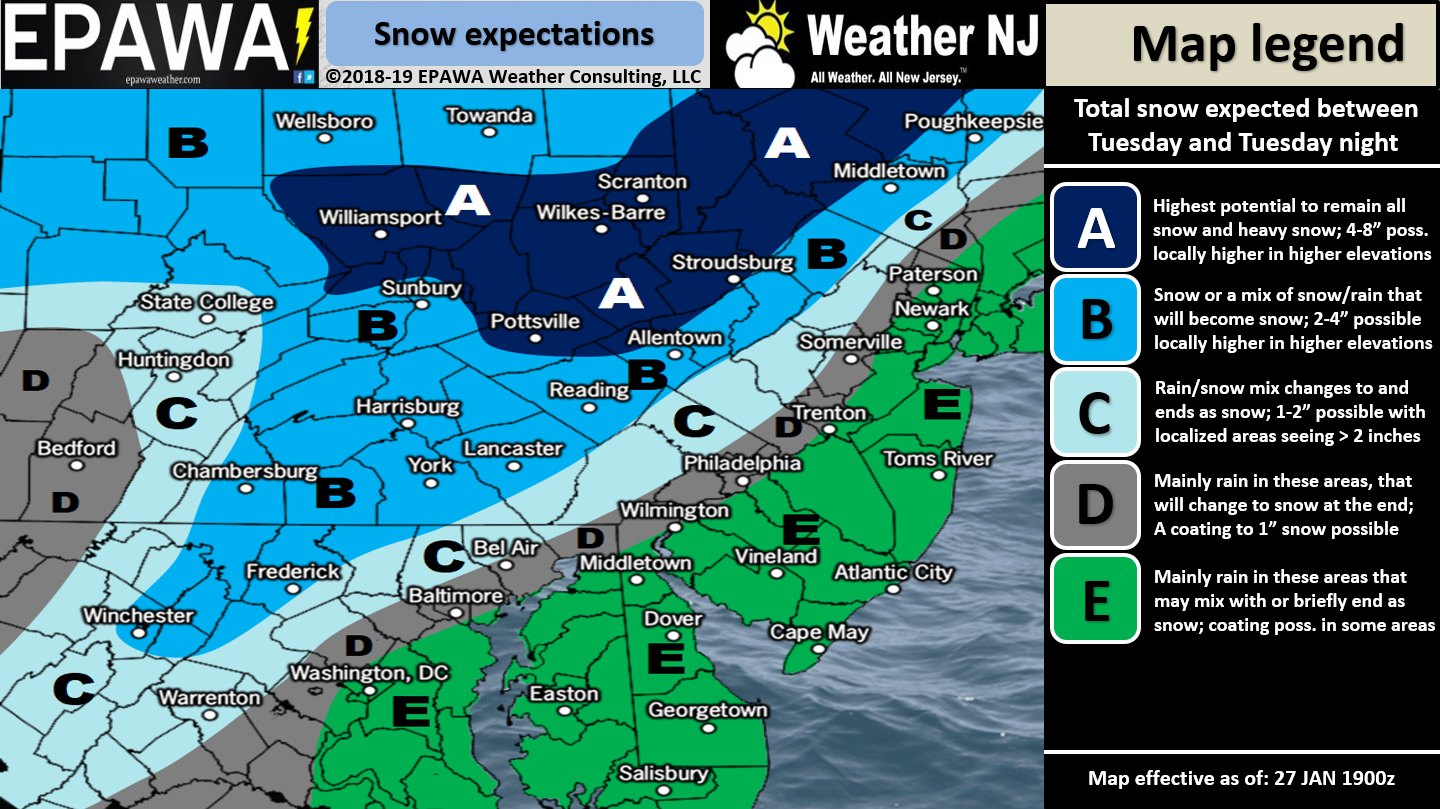
For full-resolution snow map please click here!
Discussion: An Arctic cold front will plow through our region Tuesday night which should then keep most of NJ below freezing, even during afternoon high temperatures, from Wednesday-Sunday. Along the cold frontal passage Tuesday PM exists the chance for rain to move in and change to snow. There is also energy rounding the trough that should slide up the Arctic front and enhance precipitation before the tropospheric polar vortex air mass fully settles across our region.
The best guess right now on timing is between Tuesday afternoon and the early AM hours of Wednesday with peak conditions realized Tuesday night. Precipitation could start as rain for many. NWNJ (N of 202/NW of I-287) have the best chance to see snowfall accumulations after the changeover. SENJ has the least chance for ending-accumulations as said area will see the temp crash last/closer to precip ending. Since temperatures will be crashing very fast through this precipitation and just-after, untreated wet roads will likely freeze if they cannot evaporate in-time. This could impact the Wednesday AM rush hour commute with icy conditions. Once the system pulls away Wednesday we should stay bitterly cold until Sunday. Sunday should eventually warm-up above freezing for most but elevations could hold onto the cold through Tuesday.
In English: Expect settled but cold conditions tonight through Monday. Tuesday should start relatively mild as rainfall moves in by early-afternoon. Rainfall should then change to snow during Tuesday PM hours as an Arctic cold front moves through from NW to SE. NWNJ should be first to changeover and therefore has the best chance for snow accumulations. SENJ should be the last to changeover and therefore has the least chance for snow accumulations. Our above impact map illustrates our current thinking for now. Expect gusty winds with both the frontal passage and afterwards when the bitter cold air mass blows back in. Most of NJ should then stay below freezing from Wednesday through Sunday morning. NNJ elevations could possibly stay below freezing from Wednesday through next Tuesday. No other snow storms signals on the horizon and overall signals point towards a period of mild temperatures (relative to winter) from ~February 3 until ~February 10. The colder pattern is then expected to reload again. Download the new free Weather NJ mobile app on Apple and/or Android. It’s the easiest way to never miss Weather NJ content. Have a great night and please be safe! JC
Jonathan Carr (JC) is the founder and sole operator of Weather NJ, New Jersey’s largest independent weather reporting agency. Since 2010, Jonathan has provided weather safety and forecasting services for New Jersey and immediate surrounding areas through the web, social media, and app spaces. Originally branded as Severe NJ Weather (before 2014), Weather NJ is proud to bring you accurate and responsible discussions ahead of high-stakes weather scenarios that impact the garden state. All Weather. All New Jersey.™


LOCAL FORECAST | INTERACTIVE RADAR | LATEST NJ WEATHER ALERTS | WEDDING FORECAST| PRIVACY POLICY
© Copyright 2024 Weather NJ LLC. All Rights Reserved.
Some information that can be found on our website is provided by a private weather station and is not an officially recognized station for weather reporting. Though we always strive to achieve accurate reporting for our own use, it is important that you do NOT depend on the data provided here for any purpose.
