

Jan 3: Weekend Snow Update
Snowfall is very much still on the table this weekend. Let’s break it down…
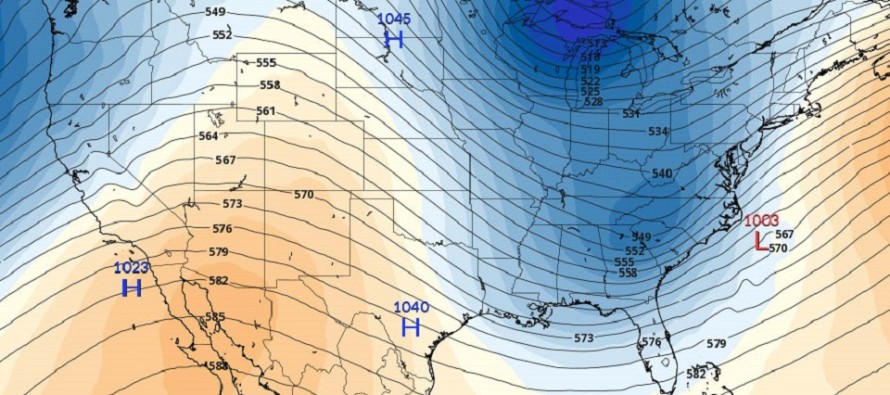
After reviewing today’s 12Z and 18Z model guidance I’ve noticed a few trends. It still looks like there will be two different waves. One Friday morning and the other Saturday into Sunday. The first wave has been indicating just light snow for most of the state. No changes on that. The second wave however has trended towards something possibly larger. This is because of the increased upper-level interaction between the shortwaves of the polar and subtropical pieces of energy. The increased interaction would lead to a deeper overall trough across the Eastern US but slightly W of where it has been modeled. The polar shortwave would be held back while the subtropical shortwave progresses and strengthens—creating an overall neutral tilt to a deeper trough. The deeper trough is supported by increasing heights in the W US (+PNA). Further downstream, increasing heights along the east coast allow the surface low to turn up the coast more.
Therefore at the surface, we’re seeing SENJ being targeted for the jackpot accumulations. This is because temperatures are of no concern (it’s plenty cold enough from surface to aloft for snow to fall and stick). Also, the SENJ coast has closest proximity to the low that’s trying to come up the coast. NWNJ is currently modeled for very little with a sharp cut-off running through NJ near the I-95 corridor.
I think this has room to trend further N and W in the next 12-24 hours of model guidance as energy comes onshore in the NW US. A westward trend to this would mean even higher jackpot totals for SENJ and more of CNJ/NNJ/EPA getting in on the action. We’re not there yet but I think it’s safe to say that SENJ (all of NJ SE of the Turnpike) is currently the most favored for snowfall through this weekend.
How could this weekend go wrong? If the first wave is stronger then it could force the second wave to miss to our S via cold suppression. This currently represents the outlying model guidance (GFS). The rest of model guidance, especially the European op/ensembles, UK and Canadian, have been trending towards a stronger second system with more wintry impacts for SNJ. I’ll have another video posted tomorrow evening.
In English: There is an increasing chance of light snow this Friday morning statewide. Nothing crazy. There is then an increasing chance for heavier snowfall, especially for those SE of the turnpike, Saturday into Sunday. I’ll have another video out tomorrow night and will plan to discuss probabilities and expected amounts.
My Pocket Meteorologist services are running on all cylinders and there’e never been a better time to sign up. We’re doing round-the-clock model analysis (run by run) in the premium forum for this storm system and frequent hyper-local text notifications will soon be starting for expected areas of impact. Have a great night and please be safe! JC
Jonathan Carr (JC) is the founder and sole operator of Weather NJ, New Jersey’s largest independent weather reporting agency. Since 2010, Jonathan has provided weather safety and forecasting services for New Jersey and immediate surrounding areas through the web, social media, and app spaces. Originally branded as Severe NJ Weather (before 2014), Weather NJ is proud to bring you accurate and responsible discussions ahead of high-stakes weather scenarios that impact the garden state. All Weather. All New Jersey.™


LOCAL FORECAST | INTERACTIVE RADAR | LATEST NJ WEATHER ALERTS | WEDDING FORECAST| PRIVACY POLICY
© Copyright 2024 Weather NJ LLC. All Rights Reserved.
Some information that can be found on our website is provided by a private weather station and is not an officially recognized station for weather reporting. Though we always strive to achieve accurate reporting for our own use, it is important that you do NOT depend on the data provided here for any purpose.
