

Jan 30: Snow Map for Tomorrow
This time NNJ is targeted for a light snow event. Let’s break it down…
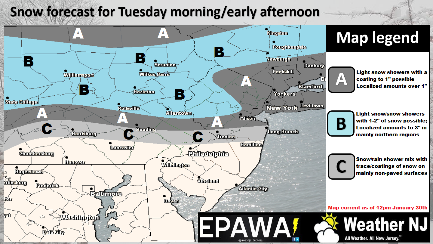
Click here to view full resolution snow map.
Disco: A quick moving shortwave will trail the system that brought snow to extreme SENJ this morning. At the surface, low pressure should move along the northern stream through our region before transferring to the coast to our N. This transfer could have huge implications at the surface, especially should it open up a dry slot. That would put accumulations on the lower side of the expected range. If the system holds on slightly longer before transferring then some NNJ areas might over-perform. Our best guess in the middle is represented by our map above (collaborated on by Eastern PA Weather and Weather NJ).
Only 2 days left to get your Kaboom hoodie. A portion of proceeds will go towards the Osprey Project of Conserve Wildlife Foundation of NJ. Purchase does not guarantee snow, only a sweet selfie 8)

In English: NNJ should see a period of fast moving snow showers tomorrow morning into afternoon hours. Snow could start before noon but everything should wrap up by evening. When all is said and done, the above snow map represents our thoughts on surface accumulations.
I know everyone is curious about the larger winter storm possibility this Sunday (Superbowl Sunday) into Monday. Let’s get tomorrow’s system out of the way and start to look at real data approaching the W US off the Pacific. For now, the general winter storm signal is still there. Have a great night and please be safe! JC
Jonathan Carr (JC) is the founder and sole operator of Weather NJ, New Jersey’s largest independent weather reporting agency. Since 2010, Jonathan has provided weather safety and forecasting services for New Jersey and immediate surrounding areas through the web, social media, and app spaces. Originally branded as Severe NJ Weather (before 2014), Weather NJ is proud to bring you accurate and responsible discussions ahead of high-stakes weather scenarios that impact the garden state. All Weather. All New Jersey.™


LOCAL FORECAST | INTERACTIVE RADAR | LATEST NJ WEATHER ALERTS | WEDDING FORECAST| PRIVACY POLICY
© Copyright 2024 Weather NJ LLC. All Rights Reserved.
Some information that can be found on our website is provided by a private weather station and is not an officially recognized station for weather reporting. Though we always strive to achieve accurate reporting for our own use, it is important that you do NOT depend on the data provided here for any purpose.
