

Jan 4: Light Snow Storm and Arctic Outbreak Detected!
Over the last few days, I’ve been tracking what’s known as an Alberta Clipper that’s modeled to bring light snow to New Jersey this ~Tuesday. We’re within 72 hours of the event now with strong model guidance support so it is much more likely to verify. Behind that? The coldest Arctic air we’ve seen since last winter. Let’s get nerdy:
What makes clippers unique is their origin and colder surrounding characteristics. Low pressure originates (cyclogenesis) in or around the Alberta Province of SW Canada. The energy then dives towards the mid-Atlantic and NE US bringing a very moisture starved batch of precipitation. The saving grace for clippers (that make it to the coast) are high snow ratios (inches of snow to inches of liquid). Unlike the 8:1 to 12:1 snow ratios we see from coastal lows or Pacific-origin lows, clippers can bring snow ratios of 20:1 to 30:1. That means that just a tenth of an inch of liquid can drop 2-3 inches.
Why does so much snow occur from such little liquid? Mostly because of cold surrounding air mass! When snow is formed in the mid levels of the atmosphere (frontogenesis at the 700-850mb levels = altitudes of ~5,000-10,000 feet), it crystallizes into a larger and fluffier snowflakes at colder temperatures. With clippers marginal/warmer temperature issues are of little concern given the colder air mass they occur in. If we’re talking about a clipper, temperatures are below freezing even well to the south of even Cape May. The fluffier and powdery snow is allowed to accumulate immediately on untreated surfaces. We have another colder transition moving through tomorrow that should pave the atmosphere from Canada to New Jersey for this event on Tuesday. Clippers are know for surprising rates of light accumulation. Unless they connect up with southern energy over the ocean however, they never really drop more than 3-6 inches of snow in New Jersey. The most common scenario is a quick and light C-2″/1-3″ hit.
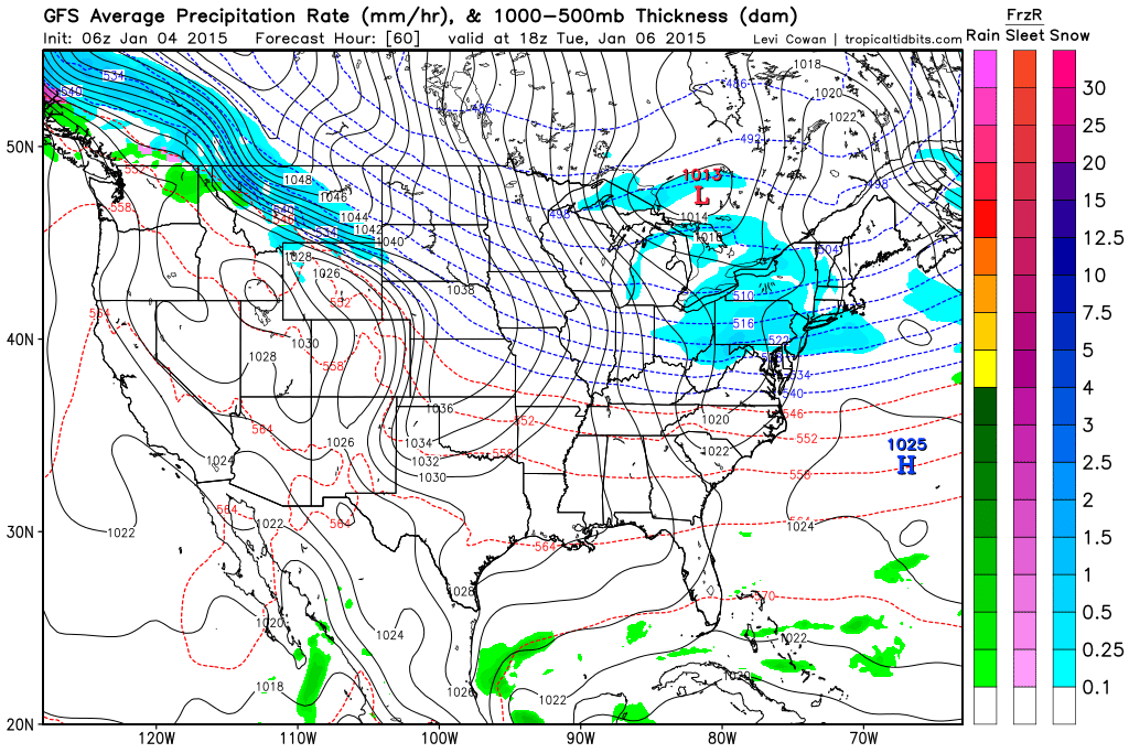
This is the latest 850mb American GFS modeling precipitation between 7AM and 1PM on this coming Tuesday. Notice the entire state is blue and the line of freezing is way to the south near the VA/NC border. This could easily drop a coating to a few inches statewide starting early Tuesday AM and lasting into the afternoon. Remember…very light and fluffy snow.
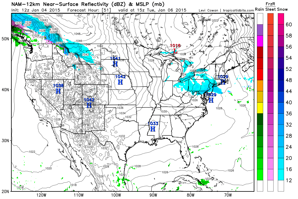
Here’s the latest American NAM, a shorter range model (now within 54 hours) showing more of the same. It also shows an extreme SNJ rob-job but take those level of details with the grain of salt.
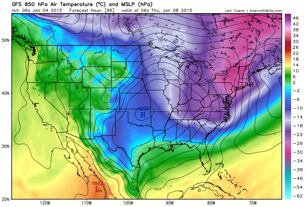
Then we turn our heads to another Arctic outbreak to close out the week. It appears that Thursday AM will be the coldest moment of this Arctic wave. This is the latest GFS showing 850mb temperatures on Thursday AM. Note the 1049mb Arctic high over Oklahoma (second Arctic high since the holidays). This translates to lows in the single digits and teens with daytime high temperatures struggling to get out of the 20s:
In English: Warm and rainy today followed by a dry and windy Monday. Temperatures then drop Monday evening. Light snow is possible early Tuesday AM into Tuesday afternoon. This could drop a surprise coating to a few inches on untreated surfaces. For now, I’ll go with 1-3″ for NNJ and C-2″ for SNJ cutting the state in half at I-195. It then gets very cold through at least Friday. Too much uncertainty exists beyond that to make a confident call. Given the Polar Vortex split seen here at 10mb, the warmer long range model guidance will either verify or be embarrassed. I give that 50/50 at best as of now. I will have a snow map out tomorrow afternoon for the expected Tuesday clipper. Be safe! JC

Jonathan Carr (JC) is the founder and sole operator of Weather NJ, New Jersey’s largest independent weather reporting agency. Since 2010, Jonathan has provided weather safety and forecasting services for New Jersey and immediate surrounding areas through the web, social media, and app spaces. Originally branded as Severe NJ Weather (before 2014), Weather NJ is proud to bring you accurate and responsible discussions ahead of high-stakes weather scenarios that impact the garden state. All Weather. All New Jersey.™


LOCAL FORECAST | INTERACTIVE RADAR | LATEST NJ WEATHER ALERTS | WEDDING FORECAST| PRIVACY POLICY
© Copyright 2024 Weather NJ LLC. All Rights Reserved.
Some information that can be found on our website is provided by a private weather station and is not an officially recognized station for weather reporting. Though we always strive to achieve accurate reporting for our own use, it is important that you do NOT depend on the data provided here for any purpose.
