

Jan 4: Weekend Snow Update Video
Snow starts as early as tomorrow. Let’s break it down…
We’re still primarily focused on the first wave of the weekend which should bring snow to the entire region Thursday PM into Friday morning. Below is my latest video update.
Below is our snow map (collaborated on by Eastern PA Weather Authority & Weather NJ) for the first wave starting Thursday PM.
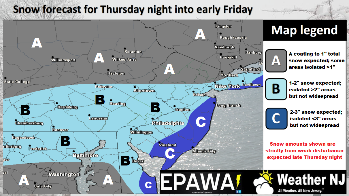
Click here to view full resolution snow map.
An Arctic cold front is currently moving through tonight. This will establish temperatures cold enough for snow to fall and stick region-wide through at least the weekend. So no matter what, we’re not dealing with rain. Whatever falls will be white with excellent stickage. In fact, the colder temperatures will allow higher snow ratios. Normally we see 10:1 on average but the upcoming event(s) could be 15:1 even 20:1 for every inch of liquid that falls.
The first wave is looking like a light-to-moderate event. Light for those away from the ocean and possibly heavier for SENJ. The map is straight-forward above and allows for a small over-performance in the darker blue. If dynamics were to enhance a bit then we could be looking at more significant totals in the darker blue area. However, the most rational call is listed in the legend of the map.
The second wave which has been advertised for Saturday into Sunday is still uncertain. We’re dealing with a coastal system that could send snow off the ocean as far in as the 95 corridor or possibly just graze or even miss SENJ with lighter precipitation. The jury is still out on this however recent model guidance has trended away from the larger impact scenario. We still have some time on this as tonight’s 00Z model run will be the first with better-sampled on-land data. However it is fair to state that yesterday’s guidance favored it much moreso than today’s guidance has. Let’s put this on the back burner for now and see how overnight models respond to sampling before we make any concrete forecasts.
In English: Snow is now confidently expected for Thursday PM into Friday AM. Anything from light accumulations away from the ocean to more of a moderate event along the coast is expected and is indicated by the map above. Saturday into Sunday is still uncertain regarding how far precipitation will reach into NJ off the ocean. SENJ has the best chance and especially points S from there. Those along and NW of 95 have the worst chance. I’ll address this more confidently tomorrow. It is important to note that neither storm will be a major snow storm. For now, enjoy the first wave if you’re a snow lover. If not, it shouldn’t be a crippling snow storm but could present a nuisance for traffic, especially Friday AM rush hour. Thursday PM rush hour shouldn’t be too bad unless snow moves in earlier in the afternoon. Otherwise it looks like an early evening start. Now-casting will begin tomorrow as well as another update for Saturday-Sunday. Have a great night and please be safe! JC
Jonathan Carr (JC) is the founder and sole operator of Weather NJ, New Jersey’s largest independent weather reporting agency. Since 2010, Jonathan has provided weather safety and forecasting services for New Jersey and immediate surrounding areas through the web, social media, and app spaces. Originally branded as Severe NJ Weather (before 2014), Weather NJ is proud to bring you accurate and responsible discussions ahead of high-stakes weather scenarios that impact the garden state. All Weather. All New Jersey.™


LOCAL FORECAST | INTERACTIVE RADAR | LATEST NJ WEATHER ALERTS | WEDDING FORECAST| PRIVACY POLICY
© Copyright 2024 Weather NJ LLC. All Rights Reserved.
Some information that can be found on our website is provided by a private weather station and is not an officially recognized station for weather reporting. Though we always strive to achieve accurate reporting for our own use, it is important that you do NOT depend on the data provided here for any purpose.
