

Jan 5: Snow Update Video
Snow is beginning to fall and there’s more expected for the weekend. Let’s break it down…
My latest video:
Our final call for wave 1 tonight through tomorrow morning (click here to view in high resolution):
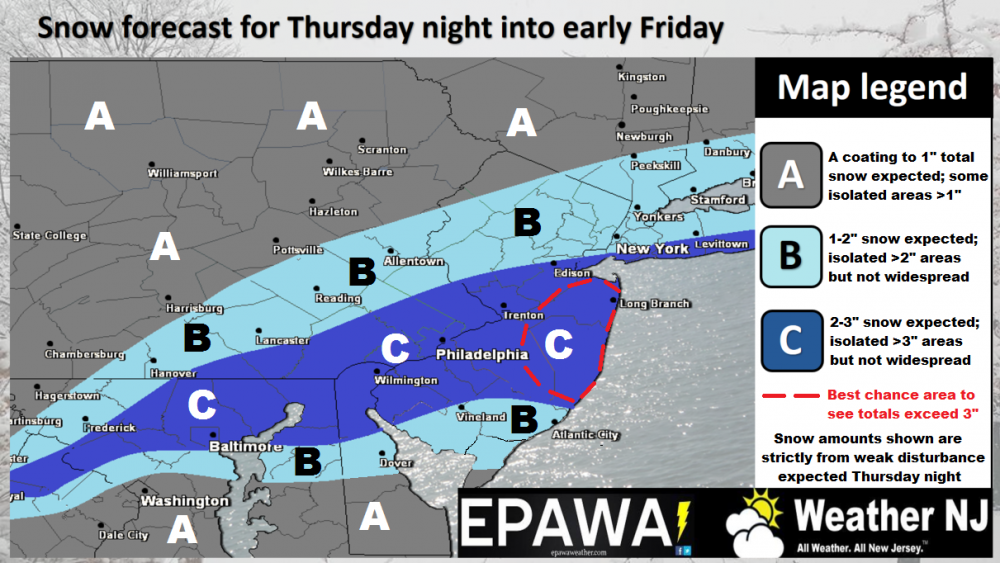
Wave 1 Disco: As evident by radar observations and a few reports, snow is now falling in parts of WNJ and will spread from W to E. This snow represents the northern part of this system coming in from the W and is only expected to be light. Once the coastal low nears and interacts with this, the precipitation shield should intensify and produce moderate snowfall rates overnight. While it’s always an 11th hour call where that heaviest band of precipitation sets up, we feel it will be between SNJ and CNJ as the map indicates. For the most part, this first wave is a light event. The red-circled area however could see accumulations greater than 3 inches should the coastal low enhance the overall precipitation shield a bit more than expected. Timing generally looks like anytime now through sunrise tomorrow morning. We should then see a break in precipitation until Saturday morning.
Our first call for wave 2 on Saturday (click here to view in high resolution):
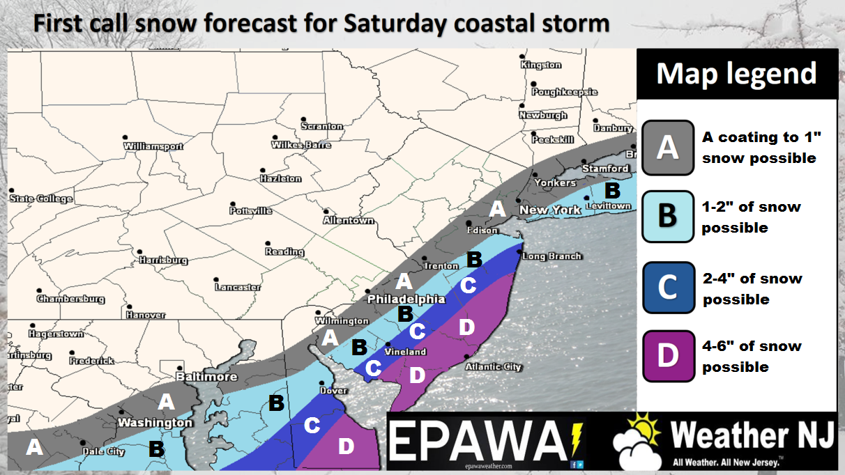
Wave 2 Disco: Guidance is almost unanimous on a stronger coastal low. This is due to better upper-level support, specifically the polar energy hanging back, the subtropical energy racing slightly ahead, and an overall neutral-to-slightly-negative trough over the E US. This allows heights to rise for the east coast enough to support the outcome. The stronger coastal low would mean a larger precipitation shield on the storm’s NW side into New Jersey. We still feel that the I-95 corridor is about as far in as accumulating snowfall can get off the ocean. However we expect SENJ to see the most accumulations.
In English: Light snow tonight for most. Over-performance possible closer to the coast. All ends by sunrise tomorrow morning. More snow is then expected on Saturday for those SE of the I-95 corridor and could possibly result in significant accumulations for SENJ. Our maps above illustrate our thoughts best. Timing for Saturday would be morning through afternoon. Tomorrow I’ll have an update on that. Let the now-casting begin for tonight. Be safe! JC
Jonathan Carr (JC) is the founder and sole operator of Weather NJ, New Jersey’s largest independent weather reporting agency. Since 2010, Jonathan has provided weather safety and forecasting services for New Jersey and immediate surrounding areas through the web, social media, and app spaces. Originally branded as Severe NJ Weather (before 2014), Weather NJ is proud to bring you accurate and responsible discussions ahead of high-stakes weather scenarios that impact the garden state. All Weather. All New Jersey.™


LOCAL FORECAST | INTERACTIVE RADAR | LATEST NJ WEATHER ALERTS | WEDDING FORECAST| PRIVACY POLICY
© Copyright 2024 Weather NJ LLC. All Rights Reserved.
Some information that can be found on our website is provided by a private weather station and is not an officially recognized station for weather reporting. Though we always strive to achieve accurate reporting for our own use, it is important that you do NOT depend on the data provided here for any purpose.
