

July 10: What Barry Means for NJ
Discussion: If you follow weather beyond the Garden State of New Jersey you know that a tropical system is forming in the northern Gulf of Mexico. Primary impacts (high winds, flooding rain and storm surge/tide) from this tropical development (soon to be named Barry) should occur near coastal Louisiana and Mississippi. Secondary impacts (lighter winds and flooding rain) should occur for Alabama and parts of Tennessee. The Mississippi river is facing decent elevation potential from this. New Jersey however is not in danger of any primary or secondary impact from Barry.
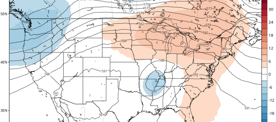
Our upper-level pattern however should be influenced in the following way. Barry will have an area of lower-height anomalies over it. That will collide with a developing ridge over the E/C US. The upper-low should pump the upper-ridge temporarily (see above image) until both forces equalize. This should occur between next Monday and Friday. What this means for New Jersey is a heat wave and likely the hottest temps of the year so far.
Once the upper dynamics equalize New Jersey should return to average geopotential height anomalies which will cool us off at the surface. The intensity of the ridge and the heat it will produce at the surface in NJ is directly related to Barry’s upper-level closed off energy. Without Barry the ridge would likely develop weaker which would mean temperatures not as hot next week.
In the shorter-term expect rain and thunderstorms to push through between early Thursday afternoon and early Friday morning (clearing by rush hour). The cold front will likely not move through until later Friday. So most Thursday PM and Friday AM rain and storm activity should occur under warm and humid conditions. The weekend, at this point, is looking pretty good once the Friday nonsense clears out. When I say good I mean warm, not too humid, and mostly sunny—about what you want for a mid-July weekend.
In English: Barry will likely slam into Louisiana and make it very warm and humid for New Jersey between next Monday and Friday. Thunderstorms should be around but the heat and humidity should dominate the headlines for next Monday-Friday. For now rain and thunderstorms are likely Thursday PM through Friday AM. The weekend looks dry as of now but temps and humidity should build by Sunday ahead of the real hot stuff Monday-forward. According to long range model data we should cool off and dry out next Saturday as the heat wave ends. I’ll be keeping close watch on this and will speak more to it all tomorrow night in the weekend outlook. Have a great rest of your Wednesday and please be safe! JC
Jonathan Carr (JC) is the founder and sole operator of Weather NJ, New Jersey’s largest independent weather reporting agency. Since 2010, Jonathan has provided weather safety and forecasting services for New Jersey and immediate surrounding areas through the web, social media, and app spaces. Originally branded as Severe NJ Weather (before 2014), Weather NJ is proud to bring you accurate and responsible discussions ahead of high-stakes weather scenarios that impact the garden state. All Weather. All New Jersey.™


LOCAL FORECAST | INTERACTIVE RADAR | LATEST NJ WEATHER ALERTS | WEDDING FORECAST| PRIVACY POLICY
© Copyright 2024 Weather NJ LLC. All Rights Reserved.
Some information that can be found on our website is provided by a private weather station and is not an officially recognized station for weather reporting. Though we always strive to achieve accurate reporting for our own use, it is important that you do NOT depend on the data provided here for any purpose.
