

July 16: Thunderstorms Expected Tomorrow

Discussion: Today we saw a few pop-up downpours and storms mostly triggered by the sea breeze front. Always fun to see a sea breeze front make it that far inland. We’re still in the warm sector however (not much humidity relief) supported by the Bermuda high return flow and the low pressure center moving through SE Canada. Until the approaching high over the Great Lakes pushes a linear storm-front through New Jersey tomorrow afternoon/early evening, we’ll deal with the humid warm sector S/SE flow.
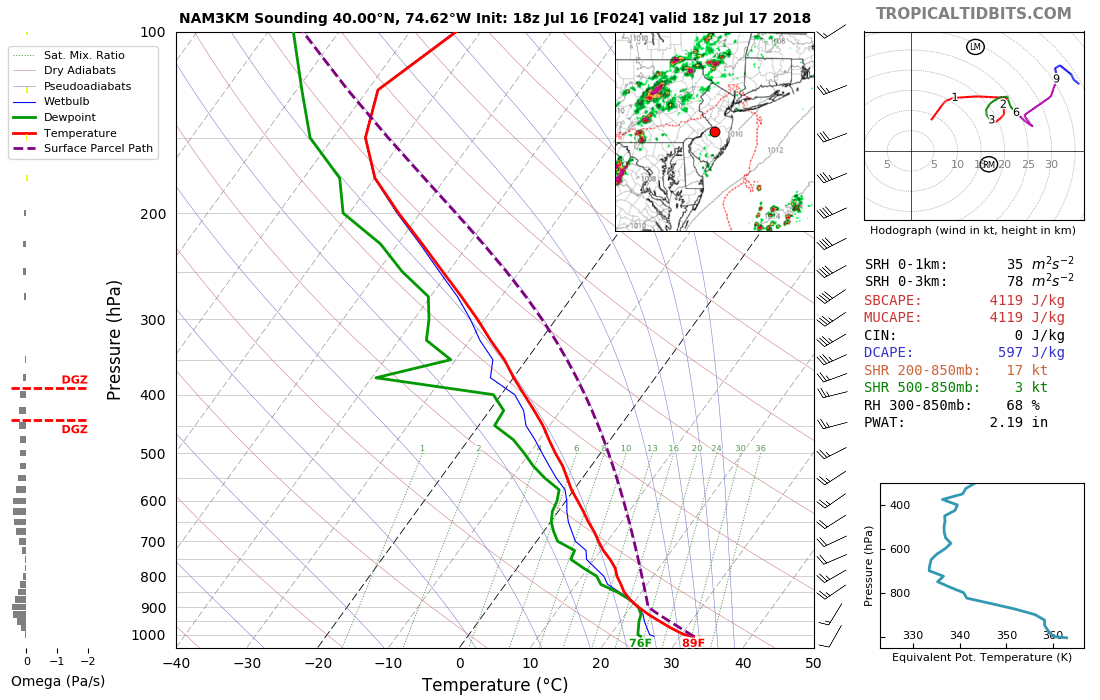
The storm front itself should be thin and broken in spots. For those that do get hit, there should be strong diurnal instability ahead of this front and marginally sufficient shear along the triggering (lifting) cold front itself. I could easily see severe thunderstorm criteria met by the National Weather Service in Mount Holly, NJ. Here’s a random sounding for 18Z (2pm) for the center of New Jersey, courtesy of Tropical Tidbits.
Once the front is through, dew points should take a dive along with temperatures. High pressure should then have complete control of the region from Wednesday (after the frontal passage) through most of Friday (before the unsettled weekend). The front side of the approaching high should deliver N/NW flow (Wednesday-Thursday) until the high centers itself over NNJ/S New England (closer to Friday).
The weekend still looks unsettled. I see a weak disturbance coming up the E US and interacting with an upper-level low over the E Great Lakes. This would likely produce a mostly-cloudy/scattered-to-widespread rainfall environment. We still have some time for evolution but it’s starting to lock in this way.
What could go wrong? If tomorrow morning/early-afternoon is cloudier then diurnal destabilization could be inhibited. This would mean more of a rainy/breezy scene along the frontal passage rather than a frequent lightning/damaging wind scene. It’s a common wildcard in setups like this. Otherwise sun’s out? Guns out! If the storm front is broken over you but storming to your N and/or S, that’s possible too. Otherwise I would play it safe and prepare for the stronger, possibly severe, storm scenario.
In English: There’s a good chance of heavy rainfall, gusty winds, frequent lightning and gnarly skies tomorrow. My best guess on timing right now: Storm line moves across NNJ from W to E between noon and 5pm—and moves across SNJ from W to E between 3PM and 8PM (NNJ/SNJ divided at I-195). It might be 9-10PM by the time the last action clears the Cape May area. Expect muggy conditions with S/SW wind ahead of the cold front and cooler/drier conditions with NW wind behind the cold front. This should set the stage for miraculous weather Wednesday-Friday before an unsettled-looking weekend. Have a great night and please be safe! JC
Photo Credit: I took this shot in Maryland in 2014.
Jonathan Carr (JC) is the founder and sole operator of Weather NJ, New Jersey’s largest independent weather reporting agency. Since 2010, Jonathan has provided weather safety and forecasting services for New Jersey and immediate surrounding areas through the web, social media, and app spaces. Originally branded as Severe NJ Weather (before 2014), Weather NJ is proud to bring you accurate and responsible discussions ahead of high-stakes weather scenarios that impact the garden state. All Weather. All New Jersey.™


LOCAL FORECAST | INTERACTIVE RADAR | LATEST NJ WEATHER ALERTS | WEDDING FORECAST| PRIVACY POLICY
© Copyright 2024 Weather NJ LLC. All Rights Reserved.
Some information that can be found on our website is provided by a private weather station and is not an officially recognized station for weather reporting. Though we always strive to achieve accurate reporting for our own use, it is important that you do NOT depend on the data provided here for any purpose.
