

July 22: Tropical Activity Update
Tropical Depression TWO continues to churn across the Atlantic Ocean towards the Lesser Antilles. Estimated impact for the Leeward and northern Windward Islands would be Thursday morning through afternoon. Puerto Rico, Haiti, and the Dominican Republic region would then see impacts Thursday evening through Friday. As far as track and intensity beyond that, it doesn’t look good for tropical development yet alone sustainment. Dry air from the Sahara Desert initially stunted this system’s growth but it will now encounter wind shear as it nears the islands. This should help keep the system weak.
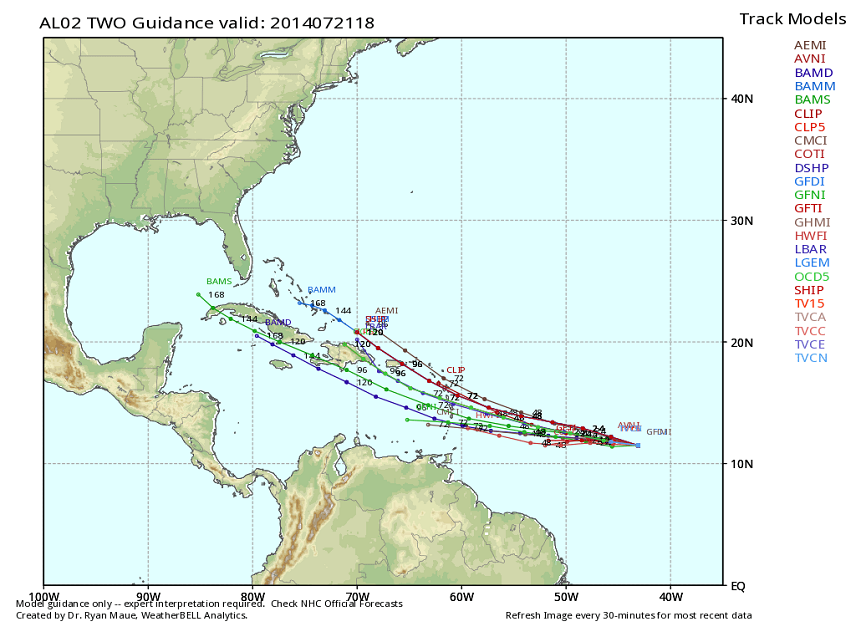
With that being said, Tropical Depression TWO will likely fizzle to just a post-tropical wave by the time it’s passing over the E. Caribbean. Currently I see no major impact for New Jersey. The absolute worst case scenario would be remnants of the wave taking a northerly turn up the east coast and bringing widespread rainfall. There would be no wind or coastal flooding. Here’s the latest tropical spaghetti showing the general projected immediate path:
If you have vacation plans in the Lesser Antilles/Puerto Rico/Dominican Rep./Haiti region this Thursday-Friday, it’s not worth freaking out about. I doubt TD02 will even reach tropical storm status. This is a laughable passing shower for that region and will probably only wash out a 6-8 hour period of time. As far as New Jersey goes, we could use the rain should a system like this decide to head up the coast. Be safe! JC
Jonathan Carr (JC) is the founder and sole operator of Weather NJ, New Jersey’s largest independent weather reporting agency. Since 2010, Jonathan has provided weather safety and forecasting services for New Jersey and immediate surrounding areas through the web, social media, and app spaces. Originally branded as Severe NJ Weather (before 2014), Weather NJ is proud to bring you accurate and responsible discussions ahead of high-stakes weather scenarios that impact the garden state. All Weather. All New Jersey.™


LOCAL FORECAST | INTERACTIVE RADAR | LATEST NJ WEATHER ALERTS | WEDDING FORECAST| PRIVACY POLICY
© Copyright 2024 Weather NJ LLC. All Rights Reserved.
Some information that can be found on our website is provided by a private weather station and is not an officially recognized station for weather reporting. Though we always strive to achieve accurate reporting for our own use, it is important that you do NOT depend on the data provided here for any purpose.
